Difference between revisions of "Rimae Plinius"
(Created page with "<div id="content_view" class="wiki" style="display: block"> =Rimae Plinius= {| class="wiki_table" | colspan="2" | Lat: 17.9°N, Long: 23.6°E, Length: 124 km, Depth: km, [...") |
|||
| (3 intermediate revisions by the same user not shown) | |||
| Line 3: | Line 3: | ||
{| class="wiki_table" | {| class="wiki_table" | ||
| colspan="2" | | | colspan="2" | | ||
| − | Lat: 17.9°N, Long: 23.6°E, Length: 124 km, Depth: km, [ | + | Lat: 17.9°N, Long: 23.6°E, Length: 124 km, Depth: km, [[R%C3%BCkl%2024|Rükl: 24]]<br /> |
|- | |- | ||
| | | | ||
| − | [http://www.lpod.org/coppermine/displayimage.php?pid=4873&fullsize=1 [[Image: | + | [http://www.lpod.org/coppermine/displayimage.php?pid=4873&fullsize=1 [[Image:Normal_rimae-plinius.jpg|external image normal_rimae-plinius.jpg]]]<br /> |
| | | | ||
| − | [http://www.lpod.org/coppermine/albums/userpics/Rimae-Plinius_LO-IV-085H_LTVT.JPG [[Image: | + | [http://www.lpod.org/coppermine/albums/userpics/Rimae-Plinius_LO-IV-085H_LTVT.JPG [[Image:Normal_Rimae-Plinius_LO-IV-085H_LTVT.JPG|external image normal_Rimae-Plinius_LO-IV-085H_LTVT.JPG]]]<br /> |
|} | |} | ||
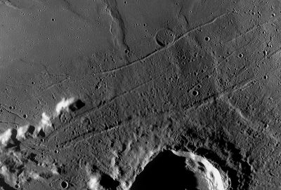
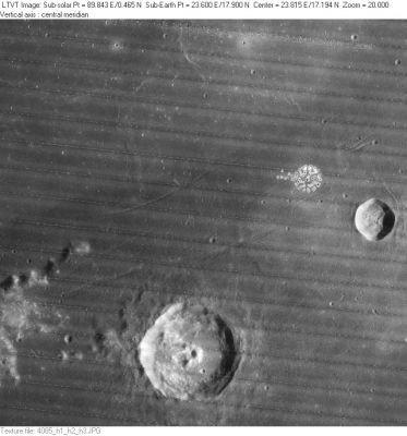
| − | '''Left:''' ''[http://lroc.sese.asu.edu/index.html LROC]'' WAC mosaic (No.'s [http://wms.lroc.asu.edu/lroc/view_lroc/LRO-L-LROC-2-EDR-V1.0/M117338672ME M117338672ME], [http://wms.lroc.asu.edu/lroc/view_lroc/LRO-L-LROC-2-EDR-V1.0/M117331904ME M117331904ME]). Processed by [http://ltvt.wikispaces.com/Utility+Programs#WAC_Viewer LROC_WAC_Previewer].<br /> '''Right:''' ''[http://lpod.org/coppermine/displayimage.php?pos=-2822 LO-IV-085H]'' '''Rimae Plinius''' refers to the grooves running horizontally across this image, which extends from [ | + | '''Left:''' ''[http://lroc.sese.asu.edu/index.html LROC]'' WAC mosaic (No.'s [http://wms.lroc.asu.edu/lroc/view_lroc/LRO-L-LROC-2-EDR-V1.0/M117338672ME M117338672ME], [http://wms.lroc.asu.edu/lroc/view_lroc/LRO-L-LROC-2-EDR-V1.0/M117331904ME M117331904ME]). Processed by [http://ltvt.wikispaces.com/Utility+Programs#WAC_Viewer LROC_WAC_Previewer].<br /> '''Right:''' ''[http://lpod.org/coppermine/displayimage.php?pos=-2822 LO-IV-085H]'' '''Rimae Plinius''' refers to the grooves running horizontally across this image, which extends from [[Promontorium%20Archerusia|Promontorium Archerusia]] on the left to the 18-km crater [[Dawes|Dawes]] on the right. The rimae are named after 43-km [[Plinius|Plinius]] at bottom center. Also visible, a little to the upper left of center and tangent to the northernmost rille is the faint 8-km crater [[Brackett|Brackett]], and to its northwest the named ridge [[Dorsum%20Nicol|Dorsum Nicol]].<br /> <div id="toc"> |
| − | + | <br /> | |
| − | |||
==Images== | ==Images== | ||
[http://www.lpod.org/coppermine/thumbnails.php?album=search&type=full&search=Rimae%20Plinius LPOD Photo Gallery] [http://www.lpi.usra.edu/resources/lunar_orbiter/bin/srch_nam.shtml?Rimae%20Plinius%7C0 Lunar Orbiter Images] [http://www.lpi.usra.edu/resources/apollo/search/feature/?feature=Rimae%20Plinius Apollo Images]<br /> <br /> | [http://www.lpod.org/coppermine/thumbnails.php?album=search&type=full&search=Rimae%20Plinius LPOD Photo Gallery] [http://www.lpi.usra.edu/resources/lunar_orbiter/bin/srch_nam.shtml?Rimae%20Plinius%7C0 Lunar Orbiter Images] [http://www.lpi.usra.edu/resources/apollo/search/feature/?feature=Rimae%20Plinius Apollo Images]<br /> <br /> | ||
==Maps== | ==Maps== | ||
| − | ''([ | + | ''([[LAC%20zone|LAC zone]] 42C4)'' [http://www.lpi.usra.edu/resources/mapcatalog/LAC/lac42/ LAC map] [http://www.lpi.usra.edu/resources/mapcatalog/usgs/I489/ Geologic map] [http://www.lpi.usra.edu/resources/mapcatalog/LM/lm42/ LM map] [http://www.lpi.usra.edu/resources/mapcatalog/LTO/lto42c4_1/ LTO map]<br /> <br /> |
==Description== | ==Description== | ||
<br /> | <br /> | ||
| Line 24: | Line 23: | ||
Rimae Plinius, Brackett, Dorsum Nicol, the northern part of crater Plinius, and Promontorium Archerusia, are depicted on the cover of the album [http://en.wikipedia.org/wiki/Apollo:_Atmospheres_and_Soundtracks APOLLO: ATMOSPHERES AND SOUNDTRACKS] by Brian Eno, Daniel Lanois, and Roger Eno (1982). This orbital handheld Hasselblad photograph ([http://www.lpi.usra.edu/resources/apollo/frame/?AS17-150-23069 AS17-150-23069]) looks great on the L.P.-edition which appeared in the early eighties!<br /> Detection of Rimae Plinius and environs on the cover of Eno's Apollo-album: Danny Caes.<br /> <br /> | Rimae Plinius, Brackett, Dorsum Nicol, the northern part of crater Plinius, and Promontorium Archerusia, are depicted on the cover of the album [http://en.wikipedia.org/wiki/Apollo:_Atmospheres_and_Soundtracks APOLLO: ATMOSPHERES AND SOUNDTRACKS] by Brian Eno, Daniel Lanois, and Roger Eno (1982). This orbital handheld Hasselblad photograph ([http://www.lpi.usra.edu/resources/apollo/frame/?AS17-150-23069 AS17-150-23069]) looks great on the L.P.-edition which appeared in the early eighties!<br /> Detection of Rimae Plinius and environs on the cover of Eno's Apollo-album: Danny Caes.<br /> <br /> | ||
==Nomenclature== | ==Nomenclature== | ||
| − | * Named from nearby crater. ([ | + | * Named from nearby crater. ([[Plinius|Plinius]]) |
| − | * Four Roman-numeralled rilles associated with [ | + | * Four Roman-numeralled rilles associated with [[Plinius|Plinius]] were part of the original IAU nomenclature of [[Blagg%20and%20M%C3%BCller|Blagg and Müller]]. Exactly when the name in its present form was adopted is unclear. <span class="membersnap">- JimMosher</span> |
| − | * It is also not clear if the rilles to the north of [ | + | * It is also not clear if the rilles to the north of [[Dawes|Dawes]] are meant to be included in this named system or not. They fall outside the official IAU diameter, but on [http://www.lpi.usra.edu/resources/mapcatalog/LTO/lto42c3_1/ LTO42C3] they are labeled as part of “Fossae Plinius”. <span class="membersnap">- JimMosher</span> |
<br /> | <br /> | ||
==LPOD Articles== | ==LPOD Articles== | ||
| Line 33: | Line 32: | ||
APOLLO OVER THE MOON; A VIEW FROM ORBIT, Chapter 4: The Maria ([http://www.hq.nasa.gov/office/pao/History/SP-362/ch4.1.htm Part 1]), Figure 59 (which is the same Hasselblad-photograph as the one on B.Eno's Apollo album-cover).<br /> <br /> | APOLLO OVER THE MOON; A VIEW FROM ORBIT, Chapter 4: The Maria ([http://www.hq.nasa.gov/office/pao/History/SP-362/ch4.1.htm Part 1]), Figure 59 (which is the same Hasselblad-photograph as the one on B.Eno's Apollo album-cover).<br /> <br /> | ||
---- | ---- | ||
| − | + | </div> | |
Latest revision as of 20:29, 16 April 2018
Contents
Rimae Plinius
|
Lat: 17.9°N, Long: 23.6°E, Length: 124 km, Depth: km, Rükl: 24 | |
Right: LO-IV-085H Rimae Plinius refers to the grooves running horizontally across this image, which extends from Promontorium Archerusia on the left to the 18-km crater Dawes on the right. The rimae are named after 43-km Plinius at bottom center. Also visible, a little to the upper left of center and tangent to the northernmost rille is the faint 8-km crater Brackett, and to its northwest the named ridge Dorsum Nicol.
Images
LPOD Photo Gallery Lunar Orbiter Images Apollo Images
Maps
(LAC zone 42C4) LAC map Geologic map LM map LTO map
Description
Description: Wikipedia
Additional Information
Rimae Plinius, Brackett, Dorsum Nicol, the northern part of crater Plinius, and Promontorium Archerusia, are depicted on the cover of the album APOLLO: ATMOSPHERES AND SOUNDTRACKS by Brian Eno, Daniel Lanois, and Roger Eno (1982). This orbital handheld Hasselblad photograph (AS17-150-23069) looks great on the L.P.-edition which appeared in the early eighties!
  Detection of Rimae Plinius and environs on the cover of Eno's Apollo-album: Danny Caes.
Nomenclature
- Named from nearby crater. (Plinius)
- Four Roman-numeralled rilles associated with Plinius were part of the original IAU nomenclature of Blagg and Müller. Exactly when the name in its present form was adopted is unclear. - JimMosher
- It is also not clear if the rilles to the north of Dawes are meant to be included in this named system or not. They fall outside the official IAU diameter, but on LTO42C3 they are labeled as part of “Fossae Plinius”. - JimMosher
LPOD Articles
Bibliography
APOLLO OVER THE MOON; A VIEW FROM ORBIT, Chapter 4: The Maria (Part 1), Figure 59 (which is the same Hasselblad-photograph as the one on B.Eno's Apollo album-cover).

