Difference between revisions of "Mädler's square"
| (One intermediate revision by the same user not shown) | |||
| Line 7: | Line 7: | ||
|- | |- | ||
| | | | ||
| − | [[Image: | + | [[Image:Mad-square-clem.jpg|mad-square-clem.jpg]]<br /> |
| | | | ||
| − | [[Image: | + | [[Image:Mad-square-annodem.jpg|mad-square-annodem.jpg]]<br /> |
| | | | ||
| − | [[Image: | + | [[Image:Mad-square-dem.jpg|mad-square-dem.jpg]]<br /> |
|} | |} | ||
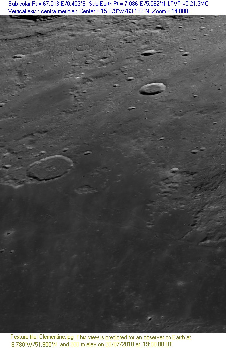
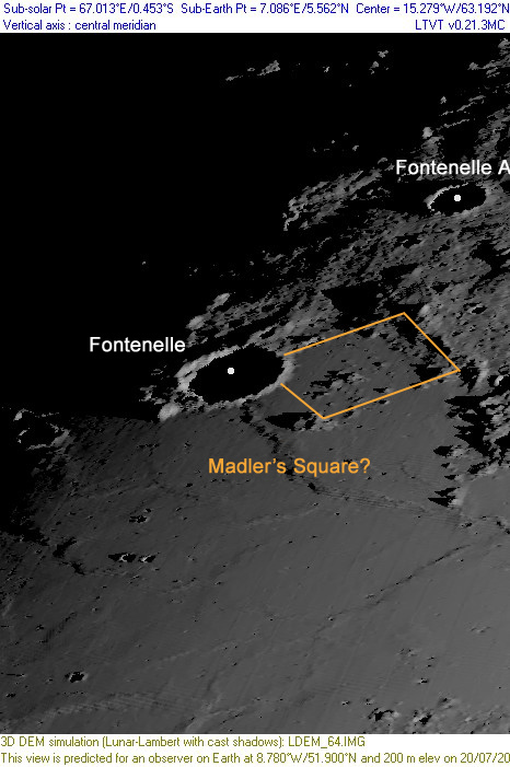
'''Left:''' ''[http://the-moon.us/wiki/file/detail/mad-square-clem.jpg Clementine]'' view of [[Fontenelle|Fontenelle]] crater and the proposed ''''Mädler's Square'''' region.<br /> '''Middle:''' ''[http://the-moon.us/wiki/file/detail/mad-square-annodem.jpg Annotated]'', DEM view of the same region at a time when the terminator had just crossed [[Fontenelle|Fontenelle]] crater during a waxing apparition (~ 11 day-old moon).<br /> | '''Left:''' ''[http://the-moon.us/wiki/file/detail/mad-square-clem.jpg Clementine]'' view of [[Fontenelle|Fontenelle]] crater and the proposed ''''Mädler's Square'''' region.<br /> '''Middle:''' ''[http://the-moon.us/wiki/file/detail/mad-square-annodem.jpg Annotated]'', DEM view of the same region at a time when the terminator had just crossed [[Fontenelle|Fontenelle]] crater during a waxing apparition (~ 11 day-old moon).<br /> | ||
| Line 17: | Line 17: | ||
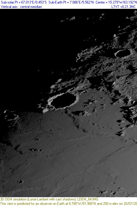
'''Right:''' The same ''[http://the-moon.us/wiki/file/detail/mad-square-dem.jpg DEM]'' view as in middle image without the annotation.<br /> | '''Right:''' The same ''[http://the-moon.us/wiki/file/detail/mad-square-dem.jpg DEM]'' view as in middle image without the annotation.<br /> | ||
| − | * All images were created using [http://ltvt.wikispaces.com/LTVT LTVT] for projections of the Clementine and DEM views (see LTVT details at top and bottom of all images). A similar series of DEM projections were also made when the terminator hadn't quite crossed over the 'square' during a waning apparition (~ 23 day-old moon), however, the 'square' wasn't quite as obvious as above. A hint, perhaps, that [[Beer%20and%20M%C3%A4dler|Beer and Mädler]]'s initial observations of the 'square' were made during a waxing apparition period. <span class="membersnap">- | + | * All images were created using [http://ltvt.wikispaces.com/LTVT LTVT] for projections of the Clementine and DEM views (see LTVT details at top and bottom of all images). A similar series of DEM projections were also made when the terminator hadn't quite crossed over the 'square' during a waning apparition (~ 23 day-old moon), however, the 'square' wasn't quite as obvious as above. A hint, perhaps, that [[Beer%20and%20M%C3%A4dler|Beer and Mädler]]'s initial observations of the 'square' were made during a waxing apparition period. <span class="membersnap">- JohnMoore2</span> |
<br /> <div id="toc"> | <br /> <div id="toc"> | ||
| Line 27: | Line 27: | ||
The informal name '''Mädler's square''' has been used to describe a region between [[Birmingham|Birmingham]] and [[Fontenelle|Fontenelle]], on the border of [[Mare%20Frigoris|Mare Frigoris]]. Amateur J. C. Bartlett drew attention to the fact that the area was drawn by [[Beer%20and%20M%C3%A4dler|Beer and Mädler]] as a square bounded by mountain walls, and described so [http://books.google.com/books?id=jkUI4moKjnQC&vq=square&pg=PA252#v=onepage&q&f=false at some length] in [[Neison%2C%201876|Neison, 1876]], yet nothing in the region has that appearance today. The southwest wall, especially, is missing according to Bartlett and Moore. Bartlett suggested this as a possibility of [[LTP|change on the Moon]], but the idea has since been discounted. Moore, for example, suggests that some of the walls seen by Mädler were an optical illusion associated with his observation with inadequate aperture of the border of a slightly darkened area, and that Neison recounted the earlier observations without verifying them.<br /> <br /> | The informal name '''Mädler's square''' has been used to describe a region between [[Birmingham|Birmingham]] and [[Fontenelle|Fontenelle]], on the border of [[Mare%20Frigoris|Mare Frigoris]]. Amateur J. C. Bartlett drew attention to the fact that the area was drawn by [[Beer%20and%20M%C3%A4dler|Beer and Mädler]] as a square bounded by mountain walls, and described so [http://books.google.com/books?id=jkUI4moKjnQC&vq=square&pg=PA252#v=onepage&q&f=false at some length] in [[Neison%2C%201876|Neison, 1876]], yet nothing in the region has that appearance today. The southwest wall, especially, is missing according to Bartlett and Moore. Bartlett suggested this as a possibility of [[LTP|change on the Moon]], but the idea has since been discounted. Moore, for example, suggests that some of the walls seen by Mädler were an optical illusion associated with his observation with inadequate aperture of the border of a slightly darkened area, and that Neison recounted the earlier observations without verifying them.<br /> <br /> | ||
==Description: Elger== | ==Description: Elger== | ||
| − | ''([[IAU% | + | ''([[IAU%20directions|IAU Directions]])''<br /> <br /> |
==Additional Information== | ==Additional Information== | ||
Latest revision as of 20:28, 16 April 2018
Contents
Mädler's square
(unofficial name)
|
Lat: 63.7°N, Long: 15.9°W, Diameter: 70 km, Depth: km, Rükl 3 | ||
Left: Clementine view of Fontenelle crater and the proposed 'Mädler's Square' region.
Middle: Annotated, DEM view of the same region at a time when the terminator had just crossed Fontenelle crater during a waxing apparition (~ 11 day-old moon).
- Note: as this interpretation is based upon comparisons of the 'square' between a graphic that appears in Patrick Moore's book Survey of the Moon and in Neison's Map 6, it is open to correction.
Right: The same DEM view as in middle image without the annotation.
- All images were created using LTVT for projections of the Clementine and DEM views (see LTVT details at top and bottom of all images). A similar series of DEM projections were also made when the terminator hadn't quite crossed over the 'square' during a waning apparition (~ 23 day-old moon), however, the 'square' wasn't quite as obvious as above. A hint, perhaps, that Beer and Mädler's initial observations of the 'square' were made during a waxing apparition period. - JohnMoore2
Images
LPOD Photo Gallery Lunar Orbiter Images
Maps
(LAC zone 12A1) LAC map Geologic map
Description
The informal name Mädler's square has been used to describe a region between Birmingham and Fontenelle, on the border of Mare Frigoris. Amateur J. C. Bartlett drew attention to the fact that the area was drawn by Beer and Mädler as a square bounded by mountain walls, and described so at some length in Neison, 1876, yet nothing in the region has that appearance today. The southwest wall, especially, is missing according to Bartlett and Moore. Bartlett suggested this as a possibility of change on the Moon, but the idea has since been discounted. Moore, for example, suggests that some of the walls seen by Mädler were an optical illusion associated with his observation with inadequate aperture of the border of a slightly darkened area, and that Neison recounted the earlier observations without verifying them.
Description: Elger
Additional Information
- From description in Neison, 1876, the square resembled "a perfect square, enclosed by long straight walls about 65 miles in length and one mile in breadth, from 250 to 300 feet in height".
- UFO enthusiasts have added additional detail to make the formation appear even more artificial.
Nomenclature
- The informal name Mädler's square appears to have been invented by Bartlett. Neison simply described it as "a perfect square" and "one of those strange objects [so perfect and regular] that seem as if they were the work of Selenites."
- Elger did use the phrase in 1888, but more as a description than as a name:
- The discrepancy between Schmidt's map of this region and those of Madler and Neison is very marked and requires investigation. The latter observers appear to exaggerate the extent of the parallelism which obtains to a certain degree among the ridges and mounds in this neighbourhood. Madler's square formation on the west is, in truth, far less regular than he represents it, and more in accordance with Schmidt's drawing. (Elger, 1888, page 429)
- Wilkins and Moore proposed calling this area Bartlett, but the IAU did not accept the suggestion.
- Several hills southwest of Birmingham (at the northern section of Mare Frigoris) received Greek letter designations, see charts 2 and 3 in the Times Atlas of the Moon, and also SLC-section D1. Are some of those hills, or perhaps all of them, part of the formation which was once called Madler's square?
LPOD Articles
Bibliography
- Bartlett, J. C. 1950. Mädler’s Square. Strolling Astron. 4(12) : 2.
- Elger, T. G. 1888. Selenographical notes. The Observatory, Vol. 11, pp. 428-429.
- Moore, P. 1951. Mädler’s Square: An alternative explanation. Strolling Astron. 5(7): 3.
- Moore, P. 1963. Survey of the Moon pp 149 - 150 (includes a small graphic representation of the supposed square - both from Beer and Mädler's 1837 perspective along with Moore's interpretation), 1963.
- Moore, P. 1965. Variations on the Surface of the Moon: An Evaluation, Irish Astronomical Journal Vol. 7, pp. 109 - 110.
- Neison, E. 1876. The Moon. page 252.


