Difference between revisions of "Collins"
| (One intermediate revision by the same user not shown) | |||
| Line 6: | Line 6: | ||
Lat: 1.3°N, Long: 23.7°E, Diam: 2 km, Depth: 0.56 km, [[R%C3%BCkl%2035|Rükl: 35]]<br /> | Lat: 1.3°N, Long: 23.7°E, Diam: 2 km, Depth: 0.56 km, [[R%C3%BCkl%2035|Rükl: 35]]<br /> | ||
|} | |} | ||
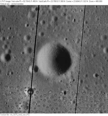
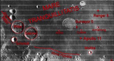
| − | [http://www.lpod.org/coppermine/albums/userpics/Collins_LO-V-75M_LTVT.JPG [[Image: | + | [http://www.lpod.org/coppermine/albums/userpics/Collins_LO-V-75M_LTVT.JPG [[Image:Normal_Collins_LO-V-75M_LTVT.JPG|external image normal_Collins_LO-V-75M_LTVT.JPG]]][http://www.lpod.org/coppermine/displayimage.php?pid=1704&fullsize=1 [[Image:Normal_Apollo_11_LO_iv_085_h1.jpg|external image normal_Apollo_11_LO_iv_085_h1.jpg]]]<br /> '''Left''': ''[http://lpod.org/coppermine/displayimage.php?pos=-2198 Lunar Orbiter V 075M]'' '''Right''' ''[http://lpod.org/coppermine/displayimage.php?pos=-1704 Lunar Orbiter IV 085 H1]'' Annotated by [[LPI|LPI]]<br /> <br /> <div id="toc"> |
==Images== | ==Images== | ||
| Line 14: | Line 14: | ||
* Apollo 10's ''Hasselblad'' frame [http://www.lpi.usra.edu/resources/apollo/frame/?AS10-31-4538 AS10-31-4538] shows an "upside-down" view of '''Collins''' (near the frame's lower margin), '''Moltke''' (the bright crater), and '''Rima Hypatia''' (aka '''''U.S. Highway Number One'''''). | * Apollo 10's ''Hasselblad'' frame [http://www.lpi.usra.edu/resources/apollo/frame/?AS10-31-4538 AS10-31-4538] shows an "upside-down" view of '''Collins''' (near the frame's lower margin), '''Moltke''' (the bright crater), and '''Rima Hypatia''' (aka '''''U.S. Highway Number One'''''). | ||
* Research Ranger 8, Lunar Orbiter 2, and Apollo 10 photographs: Danny Caes | * Research Ranger 8, Lunar Orbiter 2, and Apollo 10 photographs: Danny Caes | ||
| − | * Apollo 11's ''Hasselblad'' [http://www.lpi.usra.edu/resources/apollo/frame/?AS11-41-6119 AS11-41-6119] shows '''Collins''' near right border of frame, above center <span class="membersnap">- | + | * Apollo 11's ''Hasselblad'' [http://www.lpi.usra.edu/resources/apollo/frame/?AS11-41-6119 AS11-41-6119] shows '''Collins''' near right border of frame, above center <span class="membersnap">- Nunki</span> |
<br /> | <br /> | ||
==Maps== | ==Maps== | ||
| Line 24: | Line 24: | ||
==Additional Information== | ==Additional Information== | ||
| − | * Depth data from [[Kurt%20Fisher% | + | * Depth data from [[Kurt%20Fisher%20Crater%20Depths|Kurt Fisher database]] |
** Viscardy, 1985: 0.56 km | ** Viscardy, 1985: 0.56 km | ||
| − | * An [[LTVT|LTVT]] measurement of the shadows in [http://www.lpi.usra.edu/resources/lunarorbiter/frame/?5075 LO-V-75M] suggests the depth is closer to 430 m. The diameter also appears to be 2.75 km, a bit larger than the IAU value. <span class="membersnap">- | + | * An [[LTVT|LTVT]] measurement of the shadows in [http://www.lpi.usra.edu/resources/lunarorbiter/frame/?5075 LO-V-75M] suggests the depth is closer to 430 m. The diameter also appears to be 2.75 km, a bit larger than the IAU value. <span class="membersnap">- JimMosher</span> |
* The little crater just outside the SW rim of Collins is about 650 m in diameter and 130 m deep. This crater was part of the [[ULCN#Landmark_tracking|Apollo Landmark Tracking program]], in which Command Module pilots took sextant readings on selected targets. These were later reduced to absolute selenodetic coordinates based on the position of the Command Module as determined by radio triangulation from Earth. From Apollo 10, John Young pointed his sextant at rockslide in the northeast quadrant of the 650 m crater, while from Apollo 11, Michael Collins (for whom the larger crater was later named), used as his target a tiny craterlet just inside the north wall. Neither that crater nor the rockslide are evident in this LO-V medium resolution view. And although there is a higher resolution view available ([http://www.lpi.usra.edu/resources/lunarorbiter/frame/?5078 LO-V-078H]), the area in which these tiny targets lie is unfortunately marred by development flaws. Nonetheless, what looks like an 80 m diameter craterlet can be seen near the top of the north rim. Its [[LTVT|LTVT]]-determined coordinates are 1.305°N/23.628°E | * The little crater just outside the SW rim of Collins is about 650 m in diameter and 130 m deep. This crater was part of the [[ULCN#Landmark_tracking|Apollo Landmark Tracking program]], in which Command Module pilots took sextant readings on selected targets. These were later reduced to absolute selenodetic coordinates based on the position of the Command Module as determined by radio triangulation from Earth. From Apollo 10, John Young pointed his sextant at rockslide in the northeast quadrant of the 650 m crater, while from Apollo 11, Michael Collins (for whom the larger crater was later named), used as his target a tiny craterlet just inside the north wall. Neither that crater nor the rockslide are evident in this LO-V medium resolution view. And although there is a higher resolution view available ([http://www.lpi.usra.edu/resources/lunarorbiter/frame/?5078 LO-V-078H]), the area in which these tiny targets lie is unfortunately marred by development flaws. Nonetheless, what looks like an 80 m diameter craterlet can be seen near the top of the north rim. Its [[LTVT|LTVT]]-determined coordinates are 1.305°N/23.628°E | ||
| − | * Since this LTVT result is based on the same master image used to register the higher resolution views of crater [[West|West]], it is possible to make a test of the consistency of two systems of selenodetic coordinates. According to [http://adsabs.harvard.edu/abs/1972Moon....5..149W Wollenhaupt et al.], the correct location of Michael Collins's tiny target crater (known as target 130"/11) in the Mean Earth/Polar Axis lunar coordinate system is (1.26 +/- 0.02)°N / (23.66+/-0.01)°E, indicating that the LTVT reported values need to be corrected by -0.04 degrees in latitude and +0.03 degrees in longitude. Given the uncertainty of 0.01 to 0.02 degrees in the landmark tracking results, this is quite consistent with the corrections that need to be applied to the LTVT readouts (based on the much less precise [[ULCN#ULCN_1994|1994 ULCN]]) to give the Apollo 11 Laser Ranging Retroreflector (LRRR) its correct position in the detailed views. This means that at least in this small area of the Moon the Apollo Landmark Tracking and LRRR experiments gave consistent results, and produced coordinate systems that are offset from the [[ULCN#ULCN_1994|1994 ULCN]] by the same amount.<span class="membersnap">- | + | * Since this LTVT result is based on the same master image used to register the higher resolution views of crater [[West|West]], it is possible to make a test of the consistency of two systems of selenodetic coordinates. According to [http://adsabs.harvard.edu/abs/1972Moon....5..149W Wollenhaupt et al.], the correct location of Michael Collins's tiny target crater (known as target 130"/11) in the Mean Earth/Polar Axis lunar coordinate system is (1.26 +/- 0.02)°N / (23.66+/-0.01)°E, indicating that the LTVT reported values need to be corrected by -0.04 degrees in latitude and +0.03 degrees in longitude. Given the uncertainty of 0.01 to 0.02 degrees in the landmark tracking results, this is quite consistent with the corrections that need to be applied to the LTVT readouts (based on the much less precise [[ULCN#ULCN_1994|1994 ULCN]]) to give the Apollo 11 Laser Ranging Retroreflector (LRRR) its correct position in the detailed views. This means that at least in this small area of the Moon the Apollo Landmark Tracking and LRRR experiments gave consistent results, and produced coordinate systems that are offset from the [[ULCN#ULCN_1994|1994 ULCN]] by the same amount.<span class="membersnap">- JimMosher</span> |
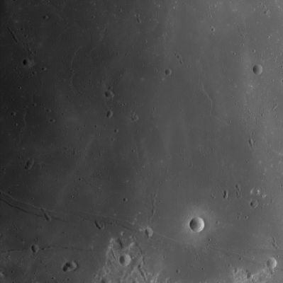
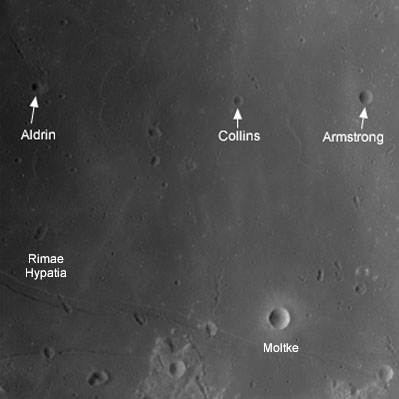
| − | * Image below shows the three craters named in honour for Apollo 11 astronauts Edwin Aldrin, Michael Collins, and Neil Armstrong.<br /> [http://www.lpod.org/coppermine/displayimage.php?pid=4882&fullsize=1 [[Image: | + | * Image below shows the three craters named in honour for Apollo 11 astronauts Edwin Aldrin, Michael Collins, and Neil Armstrong.<br /> [http://www.lpod.org/coppermine/displayimage.php?pid=4882&fullsize=1 [[Image:Normal_ald-col-arm.jpg|external image normal_ald-col-arm.jpg]]][[Image:Ald-col-arm-small.jpg|ald-col-arm-small.jpg]]<br /> '''Left:''' Credit: ''[http://lroc.sese.asu.edu/index.html LROC]'' mosaic image (WAC No.'s [http://wms.lroc.asu.edu/lroc/view_lroc/LRO-L-LROC-2-EDR-V1.0/M119693062ME M119693062ME], [http://wms.lroc.asu.edu/lroc/view_lroc/LRO-L-LROC-2-EDR-V1.0/M119686284ME M119686284ME], [http://wms.lroc.asu.edu/lroc/view_lroc/LRO-L-LROC-2-EDR-V1.0/M119706645ME M119706645ME], [http://wms.lroc.asu.edu/lroc/view_lroc/LRO-L-LROC-2-EDR-V1.0/M119699867ME M119699867ME]) ''Click for larger view''. Calibrated by [http://ltvt.wikispaces.com/Utility%20Programs#WAC_Viewer LROC_WAC_Previewer].<br /> '''Right:''' Reference image. |
<br /> | <br /> | ||
==Nomenclature== | ==Nomenclature== | ||
Latest revision as of 21:08, 16 April 2018
Contents
Collins
(formerly Sabine D)
|
Lat: 1.3°N, Long: 23.7°E, Diam: 2 km, Depth: 0.56 km, Rükl: 35 |


Left: Lunar Orbiter V 075M Right Lunar Orbiter IV 085 H1 Annotated by LPI
Images
LPOD Photo Gallery Lunar Orbiter Images Apollo Images SMART-1
- Ranger 8 - Frame B072 shows Sabine D (Collins) near the lower margin of the photograph.
- Lunar Orbiter 2 - Frame 2076 med shows Collins slightly above centre.
- Apollo 10's Hasselblad frame AS10-31-4538 shows an "upside-down" view of Collins (near the frame's lower margin), Moltke (the bright crater), and Rima Hypatia (aka U.S. Highway Number One).
- Research Ranger 8, Lunar Orbiter 2, and Apollo 10 photographs: Danny Caes
- Apollo 11's Hasselblad AS11-41-6119 shows Collins near right border of frame, above center - Nunki
Maps
(LAC zone 60C4) LAC map Geologic map LM map AIC map
USGS Geologic Map of the Sabine D region (I-618), including the landing sites of Surveyor 5 and Apollo 11.
Description
Description: Wikipedia
Additional Information
- Depth data from Kurt Fisher database
- Viscardy, 1985: 0.56 km
- An LTVT measurement of the shadows in LO-V-75M suggests the depth is closer to 430 m. The diameter also appears to be 2.75 km, a bit larger than the IAU value. - JimMosher
- The little crater just outside the SW rim of Collins is about 650 m in diameter and 130 m deep. This crater was part of the Apollo Landmark Tracking program, in which Command Module pilots took sextant readings on selected targets. These were later reduced to absolute selenodetic coordinates based on the position of the Command Module as determined by radio triangulation from Earth. From Apollo 10, John Young pointed his sextant at rockslide in the northeast quadrant of the 650 m crater, while from Apollo 11, Michael Collins (for whom the larger crater was later named), used as his target a tiny craterlet just inside the north wall. Neither that crater nor the rockslide are evident in this LO-V medium resolution view. And although there is a higher resolution view available (LO-V-078H), the area in which these tiny targets lie is unfortunately marred by development flaws. Nonetheless, what looks like an 80 m diameter craterlet can be seen near the top of the north rim. Its LTVT-determined coordinates are 1.305°N/23.628°E
- Since this LTVT result is based on the same master image used to register the higher resolution views of crater West, it is possible to make a test of the consistency of two systems of selenodetic coordinates. According to Wollenhaupt et al., the correct location of Michael Collins's tiny target crater (known as target 130"/11) in the Mean Earth/Polar Axis lunar coordinate system is (1.26 +/- 0.02)°N / (23.66+/-0.01)°E, indicating that the LTVT reported values need to be corrected by -0.04 degrees in latitude and +0.03 degrees in longitude. Given the uncertainty of 0.01 to 0.02 degrees in the landmark tracking results, this is quite consistent with the corrections that need to be applied to the LTVT readouts (based on the much less precise 1994 ULCN) to give the Apollo 11 Laser Ranging Retroreflector (LRRR) its correct position in the detailed views. This means that at least in this small area of the Moon the Apollo Landmark Tracking and LRRR experiments gave consistent results, and produced coordinate systems that are offset from the 1994 ULCN by the same amount.- JimMosher
- Image below shows the three craters named in honour for Apollo 11 astronauts Edwin Aldrin, Michael Collins, and Neil Armstrong.


Left: Credit: LROC mosaic image (WAC No.'s M119693062ME, M119686284ME, M119706645ME, M119699867ME) Click for larger view. Calibrated by LROC_WAC_Previewer.
Right: Reference image.
Nomenclature
- Named for Michael Collins (October 31, 1930-living), an American astronaut who flew on Gemini 10 and Apollo 11, where he served as the command module pilot. While he orbited the Moon, Neil Armstrong and Buzz Aldrin performed the first manned landing on the lunar surface.
- This replacement name for a formerly lettered crater was among the list of 12 names of living astronauts and cosmonauts (six each) approved by the IAU in 1970 and published in Menzel, 1971.
- A peculiar "zigzag"-shaped cluster of craterlets immediately south-southwest of Collins (Sabine D) seems to have been nicknamed The "Z" during the heydays of the first manned lunar landing, see LPOD Monday Morning Quarterbacking, 4 decades later.
- The small elongated cluster of depressions immediately northeast of Collins was nicknamed Chain Gulch during the heydays of Project Apollo, see Phil Stooke's LPOD US-1 and Other Signposts.
LPOD Articles
Lunar 100
L90: "Armstrong, Aldrin & Collins" - Small craters near the Apollo 11 landing site.
Bibliography
Michael Collins, Apollo 11:
- "First Explorers on the Moon; the incredible story of Apollo 11" (in five parts). National Geographic (December 1969).