Difference between revisions of "Tannerus"
(Created page with "<div id="content_view" class="wiki" style="display: block"> =Tannerus= {| class="wiki_table" | Lat: 56.4°S, Long: 22.0°E, Diam: 28 km, Depth: 2.28 km, [/R%C3%BCkl%2074 R...") |
|||
| Line 3: | Line 3: | ||
{| class="wiki_table" | {| class="wiki_table" | ||
| | | | ||
| − | Lat: 56.4°S, Long: 22.0°E, Diam: 28 km, Depth: 2.28 km, [ | + | Lat: 56.4°S, Long: 22.0°E, Diam: 28 km, Depth: 2.28 km, [[R%C3%BCkl%2074|Rükl: 74]]<br /> |
|} | |} | ||
<div id="toc"> | <div id="toc"> | ||
| Line 11: | Line 11: | ||
[http://www.lpod.org/coppermine/thumbnails.php?album=search&type=full&search=Tannerus LPOD Photo Gallery] [http://www.lpi.usra.edu/resources/lunar_orbiter/bin/srch_nam.shtml?Tannerus%7C0 Lunar Orbiter Images]<br /> <br /> | [http://www.lpod.org/coppermine/thumbnails.php?album=search&type=full&search=Tannerus LPOD Photo Gallery] [http://www.lpi.usra.edu/resources/lunar_orbiter/bin/srch_nam.shtml?Tannerus%7C0 Lunar Orbiter Images]<br /> <br /> | ||
==Maps== | ==Maps== | ||
| − | ''([ | + | ''([[LAC%20zone|LAC zone]] 127D2)'' [http://www.lpi.usra.edu/resources/mapcatalog/LAC/lac127/ LAC map] [http://www.lpi.usra.edu/resources/mapcatalog/usgs/I702/ Geologic map]<br /> <br /> |
==Description== | ==Description== | ||
| − | The rille on the floor of this otherwise undistinguished crater is remarkable. Rilles normally occur in mare lavas, although some do cut light plains. Considering the scarcity of rilles within craters in the southern higlands, especially far from the maria, this is unusual. With a diameter of 28 km, Tannerus may have originally had a shape like [ | + | The rille on the floor of this otherwise undistinguished crater is remarkable. Rilles normally occur in mare lavas, although some do cut light plains. Considering the scarcity of rilles within craters in the southern higlands, especially far from the maria, this is unusual. With a diameter of 28 km, Tannerus may have originally had a shape like [[Proclus|Proclus]], but it appears to have been partially filled with a floor-smoothing material.<br /> <br /> |
==Description: Elger== | ==Description: Elger== | ||
| − | ''([ | + | ''([[IAU%20Directions|IAU Directions]])'' TANNERUS.--A ring-plain, about 19 miles in diameter, between [[Mutus|Mutus]] and [[Baco|Bacon]]. It has a central mountain.<br /> <br /> |
==Description: Wikipedia== | ==Description: Wikipedia== | ||
[http://en.wikipedia.org/wiki/Tannerus_(crater) Tannerus]<br /> <br /> | [http://en.wikipedia.org/wiki/Tannerus_(crater) Tannerus]<br /> <br /> | ||
==Additional Information== | ==Additional Information== | ||
| − | * Depth data from [ | + | * Depth data from [[Kurt%20Fisher%20crater%20depths|Kurt Fisher database]] |
** Westfall, 2000: 2.28 km | ** Westfall, 2000: 2.28 km | ||
** Viscardy, 1985: 1.7 km | ** Viscardy, 1985: 1.7 km | ||
** Cherrington, 1969: 1.7 km | ** Cherrington, 1969: 1.7 km | ||
| − | * Based on the shadows from the eastern rim in LO-IV-094H, [ | + | * Based on the shadows from the eastern rim in LO-IV-094H, [[LTVT|LTVT]] returns a depth of 1,840 m. Elger appears to be mistaken about the existence of a central peak. <span class="membersnap">- [http://www.wikispaces.com/user/view/JimMosher [[Image:JimMosher-lg.jpg|16px|JimMosher]]] [http://www.wikispaces.com/user/view/JimMosher JimMosher]</span> |
<br /> | <br /> | ||
==Nomenclature== | ==Nomenclature== | ||
Revision as of 16:19, 15 April 2018
Contents
[hide]Tannerus
|
Lat: 56.4°S, Long: 22.0°E, Diam: 28 km, Depth: 2.28 km, Rükl: 74 |
Table of Contents
[#Tannerus Tannerus]
[#Tannerus-Images Images]
[#Tannerus-Maps Maps]
[#Tannerus-Description Description]
[#Tannerus-Description: Elger Description: Elger]
[#Tannerus-Description: Wikipedia Description: Wikipedia]
[#Tannerus-Additional Information Additional Information]
[#Tannerus-Nomenclature Nomenclature]
[#Tannerus-LPOD Articles LPOD Articles]
[#Tannerus-Bibliography Bibliography]

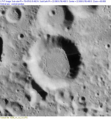
LO-IV-094H
Images
LPOD Photo Gallery Lunar Orbiter Images
Maps
(LAC zone 127D2) LAC map Geologic map
Description
The rille on the floor of this otherwise undistinguished crater is remarkable. Rilles normally occur in mare lavas, although some do cut light plains. Considering the scarcity of rilles within craters in the southern higlands, especially far from the maria, this is unusual. With a diameter of 28 km, Tannerus may have originally had a shape like Proclus, but it appears to have been partially filled with a floor-smoothing material.
Description: Elger
(IAU Directions) TANNERUS.--A ring-plain, about 19 miles in diameter, between Mutus and Bacon. It has a central mountain.
Description: Wikipedia
Additional Information
- Depth data from Kurt Fisher database
- Westfall, 2000: 2.28 km
- Viscardy, 1985: 1.7 km
- Cherrington, 1969: 1.7 km
- Based on the shadows from the eastern rim in LO-IV-094H, LTVT returns a depth of 1,840 m. Elger appears to be mistaken about the existence of a central peak. - JimMosher JimMosher
Nomenclature
- Adam Tanner (in Latin, Tannerus) (April 14, 1572 – May 25, 1632) was an Austrian Jesuit professor of mathematics and philosophy.
- Rima Tannerus and Rimae Tannerus are two unofficial names from an (almost daily) explorer of the moon's surface for the rille (or the system of rilles) on the floor of Tannerus.
LPOD Articles
Bibliography
This page has been edited 1 times. The last modification was made by - tychocrater tychocrater on Jun 13, 2009 3:24 pm - afx3u2