Difference between revisions of "Euctemon"
(Created page with "<div id="content_view" class="wiki" style="display: block"> =Euctemon= {| class="wiki_table" | Lat: 76.4°N, Long: 31.3°E, Diam: 62 km, Depth: 1.63 km, [/R%C3%BCkl%205 R...") |
|||
| Line 3: | Line 3: | ||
{| class="wiki_table" | {| class="wiki_table" | ||
| | | | ||
| − | Lat: 76.4°N, Long: 31.3°E, Diam: 62 km, Depth: 1.63 km, [ | + | Lat: 76.4°N, Long: 31.3°E, Diam: 62 km, Depth: 1.63 km, [[R%C3%BCkl%205|Rükl: 5]]<br /> |
|} | |} | ||
<div id="toc"> | <div id="toc"> | ||
| Line 11: | Line 11: | ||
[http://www.lpod.org/coppermine/thumbnails.php?album=search&type=full&search=Euctemon LPOD Photo Gallery] [http://www.lpi.usra.edu/resources/lunar_orbiter/bin/srch_nam.shtml?Euctemon%7C0 Lunar Orbiter Images]<br /> <br /> | [http://www.lpod.org/coppermine/thumbnails.php?album=search&type=full&search=Euctemon LPOD Photo Gallery] [http://www.lpi.usra.edu/resources/lunar_orbiter/bin/srch_nam.shtml?Euctemon%7C0 Lunar Orbiter Images]<br /> <br /> | ||
==Maps== | ==Maps== | ||
| − | ''([ | + | ''([[LAC%20zone|LAC zone]] 4A2)'' [http://planetarynames.wr.usgs.gov/images/Lunar/lac_4.pdf USGS Digital Atlas PDF]<br /> <br /> |
==Description== | ==Description== | ||
<br /> | <br /> | ||
==Description: Elger== | ==Description: Elger== | ||
| − | ''([ | + | ''([[IAU%20Directions|IAU Directions]])'' EUCTEMON.--This object is so close to the limb that very little can be made of its details under the most favourable conditions. According to Neison, there is a peak on the N. wall 11,000 feet in height.<br /> <br /> |
==Description: Wikipedia== | ==Description: Wikipedia== | ||
[http://en.wikipedia.org/wiki/Euctemon_(crater) Euctemon]<br /> <br /> | [http://en.wikipedia.org/wiki/Euctemon_(crater) Euctemon]<br /> <br /> | ||
==Additional Information== | ==Additional Information== | ||
| − | * Depth data from [ | + | * Depth data from [[Kurt%20Fisher%20crater%20depths|Kurt Fisher database]] |
** Westfall, 2000: 1.63 km | ** Westfall, 2000: 1.63 km | ||
** Viscardy, 1985: 2.1 km | ** Viscardy, 1985: 2.1 km | ||
Revision as of 14:47, 15 April 2018
Contents
Euctemon
|
Lat: 76.4°N, Long: 31.3°E, Diam: 62 km, Depth: 1.63 km, Rükl: 5 |
Table of Contents
[#Euctemon Euctemon]
[#Euctemon-Images Images]
[#Euctemon-Maps Maps]
[#Euctemon-Description Description]
[#Euctemon-Description: Elger Description: Elger]
[#Euctemon-Description: Wikipedia Description: Wikipedia]
[#Euctemon-Additional Information Additional Information]
[#Euctemon-Nomenclature Nomenclature]
[#Euctemon-LPOD Articles LPOD Articles]
[#Euctemon-Bibliography Bibliography]

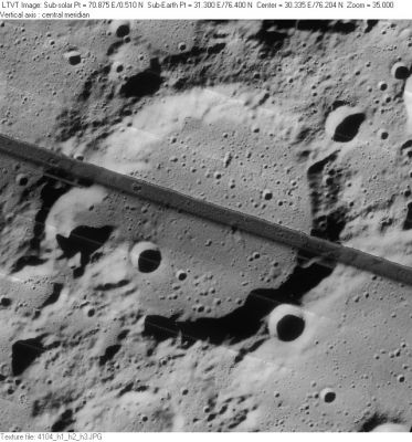
LO-IV-104H The diagonal stripe is a flaw in the film.
Images
LPOD Photo Gallery Lunar Orbiter Images
Maps
(LAC zone 4A2) USGS Digital Atlas PDF
Description
Description: Elger
(IAU Directions) EUCTEMON.--This object is so close to the limb that very little can be made of its details under the most favourable conditions. According to Neison, there is a peak on the N. wall 11,000 feet in height.
Description: Wikipedia
Additional Information
- Depth data from Kurt Fisher database
- Westfall, 2000: 1.63 km
- Viscardy, 1985: 2.1 km
- Cherrington, 1969: 2.49 km
- In LO-IV-104H, the bulge in the shadow of the southwest rim near 8-km Euctemon N is mostly a reflection of the shape of that crater, rather than an indication of an unusually high point on the rim. In this vicinity the main rim is mostly 1400-1500 tall, which is probably similar to the depth of Euctemon N (from the shadow in this view, the latter depth is at least 1300 m deep).
Nomenclature
Euctemon (unknown-fl. 432 BC) was an Athenian astronomer. He was a contemporary of Meton and worked closely with this astronomer.
Could have been Van Langren's Albategni (see page 195 in Ewen A. Whitaker's Mapping and Naming the Moon).
LPOD Articles
Bibliography
This page has been edited 1 times. The last modification was made by - tychocrater tychocrater on Jun 13, 2009 3:24 pm - afx3u2