Difference between revisions of "Dorsum Bucher"
(Created page with "<div id="content_view" class="wiki" style="display: block"> =Dorsum Bucher= {| class="wiki_table" | Lat: 31.0°N, Long: 39.0°W, Length: 90 km, Height: km, [/R%C3%BCkl%209...") |
|||
| Line 3: | Line 3: | ||
{| class="wiki_table" | {| class="wiki_table" | ||
| | | | ||
| − | Lat: 31.0°N, Long: 39.0°W, Length: 90 km, Height: km, [ | + | Lat: 31.0°N, Long: 39.0°W, Length: 90 km, Height: km, [[R%C3%BCkl%209|Rükl: 9]]<br /> |
|} | |} | ||
<div id="toc"> | <div id="toc"> | ||
| Line 11: | Line 11: | ||
[http://www.lpod.org/coppermine/thumbnails.php?album=search&type=full&search=Dorsum%20Bucher LPOD Photo Gallery] [http://www.lpi.usra.edu/resources/lunar_orbiter/bin/srch_nam.shtml?Dorsum%20Bucher%7C0 Lunar Orbiter Images] [http://www.lpi.usra.edu/resources/apollo/search/feature/?feature=Dorsum%20Bucher Apollo Images]<br /> - '''Dorsum Bucher''' was captured on four of Apollo 15's orbital ''ITEK''-panoramic frames:<br /> [http://www.lpi.usra.edu/resources/apollo/frame/?AS15-P-10306 AS15-P-10306] and [http://www.lpi.usra.edu/resources/apollo/frame/?AS15-P-10311 10311]. Both stereoscopic frames show the north-northwestern part of '''Dorsum Bucher''' (scroll to the right, beyond the centre of both frames).<br /> [http://www.lpi.usra.edu/resources/apollo/frame/?AS15-P-10304 AS15-P-10304] and [http://www.lpi.usra.edu/resources/apollo/frame/?AS15-P-10309 10309]. Both stereoscopic frames show the south-southeastern part of '''Dorsum Bucher''', with its somewhat rectilinear "coffin"-shaped oblong hill-like extension (scroll to the right, slightly beyond the centre of both frames). This oblong hill is called '''''Mons Bucher''''' by D.Caes.<br /> - Apollo 15's orbital ''Hasselblad'' frame [http://www.lpi.usra.edu/resources/apollo/frame/?AS15-92-12475 AS15-92-12475] shows the south-southeastern extension of '''Dorsum Bucher'''. Note the curious rectilinear "coffin"-like shape of the elongated '''''Mons Bucher'''''.<br /> - It ('''''Mons Bucher''''') is also noticeable "at about 2 o'clock" from the centre of Apollo 15's ''Fairchild''-metric mapping frame [http://www.lpi.usra.edu/resources/apollo/frame/?AS15-M-2741 AS15-M-2741].<br /> Research Apollo 15's ''ITEK,'' ''Hasselblad, and Fairchild'' frames: Danny Caes<br /> <br /> | [http://www.lpod.org/coppermine/thumbnails.php?album=search&type=full&search=Dorsum%20Bucher LPOD Photo Gallery] [http://www.lpi.usra.edu/resources/lunar_orbiter/bin/srch_nam.shtml?Dorsum%20Bucher%7C0 Lunar Orbiter Images] [http://www.lpi.usra.edu/resources/apollo/search/feature/?feature=Dorsum%20Bucher Apollo Images]<br /> - '''Dorsum Bucher''' was captured on four of Apollo 15's orbital ''ITEK''-panoramic frames:<br /> [http://www.lpi.usra.edu/resources/apollo/frame/?AS15-P-10306 AS15-P-10306] and [http://www.lpi.usra.edu/resources/apollo/frame/?AS15-P-10311 10311]. Both stereoscopic frames show the north-northwestern part of '''Dorsum Bucher''' (scroll to the right, beyond the centre of both frames).<br /> [http://www.lpi.usra.edu/resources/apollo/frame/?AS15-P-10304 AS15-P-10304] and [http://www.lpi.usra.edu/resources/apollo/frame/?AS15-P-10309 10309]. Both stereoscopic frames show the south-southeastern part of '''Dorsum Bucher''', with its somewhat rectilinear "coffin"-shaped oblong hill-like extension (scroll to the right, slightly beyond the centre of both frames). This oblong hill is called '''''Mons Bucher''''' by D.Caes.<br /> - Apollo 15's orbital ''Hasselblad'' frame [http://www.lpi.usra.edu/resources/apollo/frame/?AS15-92-12475 AS15-92-12475] shows the south-southeastern extension of '''Dorsum Bucher'''. Note the curious rectilinear "coffin"-like shape of the elongated '''''Mons Bucher'''''.<br /> - It ('''''Mons Bucher''''') is also noticeable "at about 2 o'clock" from the centre of Apollo 15's ''Fairchild''-metric mapping frame [http://www.lpi.usra.edu/resources/apollo/frame/?AS15-M-2741 AS15-M-2741].<br /> Research Apollo 15's ''ITEK,'' ''Hasselblad, and Fairchild'' frames: Danny Caes<br /> <br /> | ||
==Maps== | ==Maps== | ||
| − | ''([ | + | ''([[LAC%20zone|LAC zone]] 39B1)'' [http://www.lpi.usra.edu/resources/mapcatalog/LAC/lac39/ LAC map] [http://www.lpi.usra.edu/resources/mapcatalog/usgs/I465/ Geologic map] [http://www.lpi.usra.edu/resources/mapcatalog/LM/lm39/ LM map] [http://www.lpi.usra.edu/resources/mapcatalog/LTO/lto39b1_1/ LTO map]<br /> <br /> |
==Description== | ==Description== | ||
<br /> | <br /> | ||
Revision as of 14:47, 15 April 2018
Contents
Dorsum Bucher
|
Lat: 31.0°N, Long: 39.0°W, Length: 90 km, Height: km, Rükl: 9 |
Table of Contents

IV-145-H1
Images
LPOD Photo Gallery Lunar Orbiter Images Apollo Images
- Dorsum Bucher was captured on four of Apollo 15's orbital ITEK-panoramic frames:
AS15-P-10306 and 10311. Both stereoscopic frames show the north-northwestern part of Dorsum Bucher (scroll to the right, beyond the centre of both frames).
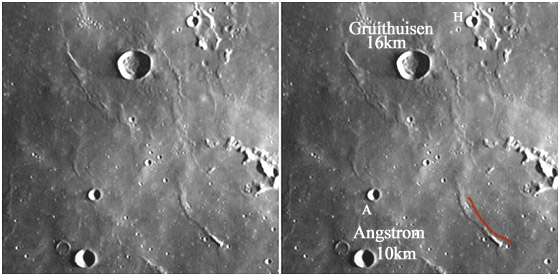
AS15-P-10304 and 10309. Both stereoscopic frames show the south-southeastern part of Dorsum Bucher, with its somewhat rectilinear "coffin"-shaped oblong hill-like extension (scroll to the right, slightly beyond the centre of both frames). This oblong hill is called Mons Bucher by D.Caes.
- Apollo 15's orbital Hasselblad frame AS15-92-12475 shows the south-southeastern extension of Dorsum Bucher. Note the curious rectilinear "coffin"-like shape of the elongated Mons Bucher.
- It (Mons Bucher) is also noticeable "at about 2 o'clock" from the centre of Apollo 15's Fairchild-metric mapping frame AS15-M-2741.
Research Apollo 15's ITEK, Hasselblad, and Fairchild frames: Danny Caes
Maps
(LAC zone 39B1) LAC map Geologic map LM map LTO map
Description
Description: Wikipedia
Additional Information
Nomenclature
- Walter Herman; American geologist (1889-1965).
  - The rectilinear-looking oblong hill at the south-southeastern end of Dorsum Bucher is unofficially called Mons Bucher by Danny Caes.
LPOD Articles
Bibliography
About Walter Herman Bucher:
  Don E. Wilhelms: To a Rocky Moon, a geologist's history of Lunar Exploration (University of Arizona Press, 1993).
This page has been edited 1 times. The last modification was made by - tychocrater tychocrater on Jun 13, 2009 3:24 pm - afx3u2