Difference between revisions of "Hansteen"
(Created page with "<div id="content_view" class="wiki" style="display: block"> =Hansteen= {| class="wiki_table" | Lat: 11.53°S, Long: 52.01°W, Diam: 44.99 km, Depth: 1.39 km, [/R%C3%BCkl%2...") |
|||
| Line 32: | Line 32: | ||
{| class="wiki_table" | {| class="wiki_table" | ||
| | | | ||
| − | [http://the-moon. | + | [http://the-moon.us/wiki/file/detail/burrell-mellonic.jpg [[Image:burrell-mellonic.jpg|burrell-mellonic.jpg]]]<br /> |
| | | | ||
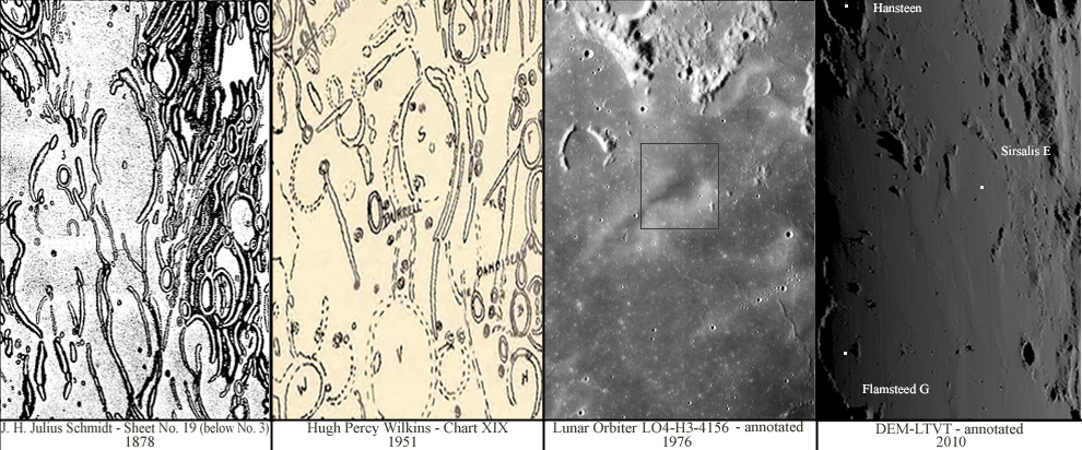
'''Left:''' The feature as it appears in Schmidt's map [/Schmidt%20-%2019 Sheet No. 19].<br /> <br /> '''Middle left:''' As it appears in Wilkins's Map - Chart XIX.<br /> <br /> '''Middle right:''' Annotated, Lunar Orbiter 4 [http://www.lpi.usra.edu/resources/lunarorbiter/images/preview/4156_h3.jpg LO4-H3-4156] aerial view (square shows the region in question as it is seen today - considered by Schmidt as '''Melloni''' crater and by Wilkins as '''Burrell''' crater).<br /> <br /> '''Right:''' Annotated, Digital Elevation Model (DEM) view under low illumination using [http://ltvt.wikispaces.com/LTVT LTVT] software as a projection method to show approximately the region where '''Burrell-Melloni''' was presumed seen.<br /> <br /> ''Click image for larger view''<br /> | '''Left:''' The feature as it appears in Schmidt's map [/Schmidt%20-%2019 Sheet No. 19].<br /> <br /> '''Middle left:''' As it appears in Wilkins's Map - Chart XIX.<br /> <br /> '''Middle right:''' Annotated, Lunar Orbiter 4 [http://www.lpi.usra.edu/resources/lunarorbiter/images/preview/4156_h3.jpg LO4-H3-4156] aerial view (square shows the region in question as it is seen today - considered by Schmidt as '''Melloni''' crater and by Wilkins as '''Burrell''' crater).<br /> <br /> '''Right:''' Annotated, Digital Elevation Model (DEM) view under low illumination using [http://ltvt.wikispaces.com/LTVT LTVT] software as a projection method to show approximately the region where '''Burrell-Melloni''' was presumed seen.<br /> <br /> ''Click image for larger view''<br /> | ||
| Line 45: | Line 45: | ||
==LPOD Articles== | ==LPOD Articles== | ||
| − | * [http:// | + | * [http://www2.lpod.org/wiki/April_30,_2006 Divergent Tracks] |
| − | * [http:// | + | * [http://www2.lpod.org/wiki/March_2,_2004 The Arrowhead. LPOD (Albedo feature Hansteen alpha and C. Hans] |
<br /> | <br /> | ||
==Bibliography== | ==Bibliography== | ||
Revision as of 19:15, 11 April 2018
Contents
Hansteen
|
Lat: 11.53°S, Long: 52.01°W, Diam: 44.99 km, Depth: 1.39 km, [/R%C3%BCkl%2040 Rükl: 40] |
Table of Contents

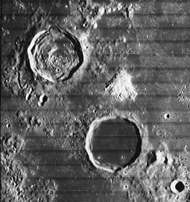
Lunar Orbiter IV image IV-149-H2, Hansteen Alpha aka [/Mons%20Hansteen Mons Hansteen] or the Arrowhead, [/Billy Billy] & Hansteen (upper left).
Images
LPOD Photo Gallery Lunar Orbiter Images Apollo Images
Maps
([/LAC%20zone LAC zone] 74C2) LAC map Geologic map
Description
Elger
([/IAU%20Directions IAU Directions]) HANSTEEN.--A somewhat larger ring-plain, with a lower and more irregular rampart, rising on the E. to nearly 3,000 feet above the floor, which is depressed to about the same extent as that of [/Billy Billy]. Both the inner and outer slopes are terraced on the W., where the glacis is traversed by a short, delicate, rill-like valley. There are some bright curved ridges on the floor. On the E. of [/Billy Billy] and Hansteen is a wide inlet of the [/Oceanus%20Procellarum Oceanus Procellarum], bounded by the [/Letronne Letronne] region on the E., and on the S. by lofty highlands. On the surface, not far from the S.E. border of Hansteen, is a curious triangular-shaped mountain mass, with a digitated outline on the S., and including a small bright crater on its area. Between this and the ring- plain is a large but somewhat obscure depression, N. of which lies a rill-like object extending from the N. point of the triangular mountain to the E. wall. At the bottom of a gently sloping valley between [/Billy Billy] and Hansteen is a de
licate marking, which seems to represent a cleft connecting the two formations.
Wikipedia
Additional Information
- IAU page: Hansteen
- Depth data from [/Kurt%20Fisher%20crater%20depths Kurt Fisher database]
- Westfall, 2000: 1.39 km
- Viscardy, 1985: 1.25 km
- Cherrington, 1969: 1.24 km
Nomenclature
- Christopher; Norwegian astronomer (1784-1873).
- A Reiner-gamma like surface formation (a swirl) north-northwest of Hansteen (at 7 degrees South, 54 degrees West) was probably called Burrell by Wilkins, and Melloni by Schmidt.
- Burrell-Melloni - a curious case of observation
|
Left: The feature as it appears in Schmidt's map [/Schmidt%20-%2019 Sheet No. 19]. |
- Note: For all images, North is to bottom, East to left (taking into account the pre-1961 cardinal-point changes - see [/IAU%20directions IAU Directions]).
- Clearly [/Julius%20Schmidt Schmidt] and [/Hugh%20Percy%20Wilkins Wilkins] show the feature as a well-marked crater, however, when looked for in the [/Beer%20and%20M%C3%A4dler Mädler] maps of 1837 and the Neison maps of 1876 [/Neison%20-%20Map%2012 Map 12], the feature doesn't appear (Mädler shows it as two small ridge-like or hill-like features, while nothing at all appears on Neison's). Other, more recent mappers have also commented about the feature's appearance/disappearance, which further confused matters, for example, see this 1959 Irish Astronomical Journal article by Larson Milling. - JohnMoore2 JohnMoore2 ??
- Burrell was a contemporary English selenographer.
- Rimae Hansteen (an unofficial name for the system of rilles on the floor of Hansteen).
LPOD Articles
Bibliography
- Hawke, B. R. et al (2011). Hansteen Alpha: A Silicic Volcanic Construct on the Moon – 42nd LPSC Conference (Mar), 2011.
- Wilkins's "Burrell" and Schmidt's "Melloni": MAPPING AND NAMING THE MOON by Ewen A. Whitaker.
- "Burrell": THE MOON by H.P.Wilkins and P.Moore.
- Milling, L. 1959. Two Lunar Formations - Irish Astronomical Journal, vol. 5(6), p. 173
[/Alphabetical%20Index Named Features] -- Prev: [/Hansen Hansen] -- Next: [/Mons%20Hansteen Mons Hansteen]
This page has been edited 1 times. The last modification was made by - tychocrater tychocrater on Jun 13, 2009 3:24 pm - afx3u3
