Difference between revisions of "Borman"
(Created page with "<div id="content_view" class="wiki" style="display: block"> =Borman= {| class="wiki_table" | Lat: 38.8°S, Long: 147.7°W, Diam: 50 km, Depth: km, Rükl: ''(farside)''<br /...") |
|||
| Line 9: | Line 9: | ||
[[Image:borman-color.jpg|borman-color.jpg]]<br /> | [[Image:borman-color.jpg|borman-color.jpg]]<br /> | ||
|} | |} | ||
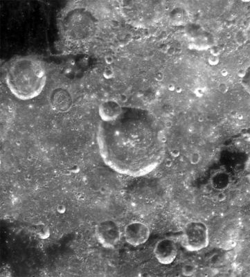
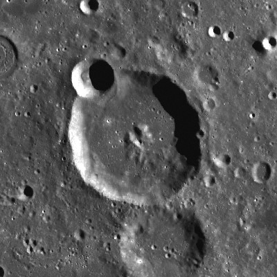
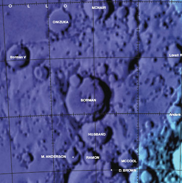
| − | ''Left:'' [http://pdsmaps.wr.usgs.gov/explorer-bin/mapmars4.cgi?WHEREFROM=DEG2&VERSION=INTERMEDIATE&DATA_SET_NAME=moon_clementine_bw&PIXEL_TYPE=BIT8&SCALE=pixels/degree&PROJECTION=SINUSOIDAL&RESOLUTION=128&RESAMP_METHOD=NEAREST_NEIGHBOR&BANDS_SELECTED=&FORMAT=JPEG&LONBOX=8&LATBOX=8&GRIDLINE_FREQUENCY=none&STRETCH=NONE&LAT=-39&LON=211.5&LINE=512&SAMP=409 Clementine]. ''Center :'' '''''LROC'''''<br /> ''Right:'' [http://planetarynames.wr.usgs.gov/images/Lunar/lac_121.pdf Colo-coded Lac 121] from [http://the-moon. | + | ''Left:'' [http://pdsmaps.wr.usgs.gov/explorer-bin/mapmars4.cgi?WHEREFROM=DEG2&VERSION=INTERMEDIATE&DATA_SET_NAME=moon_clementine_bw&PIXEL_TYPE=BIT8&SCALE=pixels/degree&PROJECTION=SINUSOIDAL&RESOLUTION=128&RESAMP_METHOD=NEAREST_NEIGHBOR&BANDS_SELECTED=&FORMAT=JPEG&LONBOX=8&LATBOX=8&GRIDLINE_FREQUENCY=none&STRETCH=NONE&LAT=-39&LON=211.5&LINE=512&SAMP=409 Clementine]. ''Center :'' '''''LROC'''''<br /> ''Right:'' [http://planetarynames.wr.usgs.gov/images/Lunar/lac_121.pdf Colo-coded Lac 121] from [http://the-moon.us/wiki/USGS%20Digital%20Atlas USGS Digital Atlas]<br /> <div id="toc"> |
=Table of Contents= | =Table of Contents= | ||
<div style="margin-left: 1em">[#Borman Borman]</div><div style="margin-left: 2em">[#Borman-Images Images]</div><div style="margin-left: 2em">[#Borman-Maps Maps]</div><div style="margin-left: 2em">[#Borman-Description Description]</div><div style="margin-left: 2em">[#Borman-Description: Wikipedia Description: Wikipedia]</div><div style="margin-left: 2em">[#Borman-Additional Information Additional Information]</div><div style="margin-left: 2em">[#Borman-Nomenclature Nomenclature]</div><div style="margin-left: 2em">[#Borman-LPOD Articles LPOD Articles]</div><div style="margin-left: 2em">[#Borman-Bibliography Bibliography]</div></div> | <div style="margin-left: 1em">[#Borman Borman]</div><div style="margin-left: 2em">[#Borman-Images Images]</div><div style="margin-left: 2em">[#Borman-Maps Maps]</div><div style="margin-left: 2em">[#Borman-Description Description]</div><div style="margin-left: 2em">[#Borman-Description: Wikipedia Description: Wikipedia]</div><div style="margin-left: 2em">[#Borman-Additional Information Additional Information]</div><div style="margin-left: 2em">[#Borman-Nomenclature Nomenclature]</div><div style="margin-left: 2em">[#Borman-LPOD Articles LPOD Articles]</div><div style="margin-left: 2em">[#Borman-Bibliography Bibliography]</div></div> | ||
| Line 15: | Line 15: | ||
[http://www.lpod.org/coppermine/thumbnails.php?album=search&type=full&search=Borman LPOD Photo Gallery] [http://www.lpi.usra.edu/resources/lunar_orbiter/bin/srch_nam.shtml?Borman%7C0 Lunar Orbiter Images] [http://www.lpi.usra.edu/resources/apollo/search/feature/?feature=Borman Apollo Images]<br /> <br /> | [http://www.lpod.org/coppermine/thumbnails.php?album=search&type=full&search=Borman LPOD Photo Gallery] [http://www.lpi.usra.edu/resources/lunar_orbiter/bin/srch_nam.shtml?Borman%7C0 Lunar Orbiter Images] [http://www.lpi.usra.edu/resources/apollo/search/feature/?feature=Borman Apollo Images]<br /> <br /> | ||
==Maps== | ==Maps== | ||
| − | ''([http://the-moon. | + | ''([http://the-moon.us/wiki/LAC%20zone LAC zone] 121A3)'' [http://planetarynames.wr.usgs.gov/images/Lunar/lac_121.pdf USGS Digital Atlas PDF]<br /> <br /> |
==Description== | ==Description== | ||
| − | '''Borman''' is a crater of the [http://the-moon. | + | '''Borman''' is a crater of the [http://the-moon.us/wiki/Stratigraphy Early Imprium] period (~ 3.75 to 3.2 bn years), and lies on the south-eastern, inner ring of the [http://the-moon.us/wiki/Apollo Apollo Basin] -- a 720 kilometre-wide basin of the [http://the-moon.us/wiki/Stratigraphy pre-Nectarian] period (~ 4.6 to 3.92 bn years). It is thus obviously higher than the surrounding area as to its north-west region ('''Apollo''') and its south-west and east (a trough region between the inner ring and rim) region respectively, show dark mare material of lower regions of lower flooded floors. '''Borman's''' rim looks relatively sharp for its age, and is only interrupted by several smaller craters -- the largest being about 20 kilometrea cross in the north-west section. The floor is somewhat level predominantly in its northern half, however, a more rougher appearance to its southern half may suggest as to hints of landslided material. All features shown in the above image lies within the north-eastern section of the [http://the-moon.us/wiki/South%20Pole-Aitken%20Basin South Pole Aitken Basin] -- a 2500 kilometre-wide basin of the [http://the-moon.us/wiki/Stratigraphy pre-Nectarian] period (~ 4.6 to 3.92 bn years).<span class="membersnap">- [http://www.wikispaces.com/user/view/JohnMoore2 [[Image:JohnMoore2-lg.jpg|16px|JohnMoore2]]] [http://www.wikispaces.com/user/view/JohnMoore2 JohnMoore2]</span><br /> <br /> |
==Description: Wikipedia== | ==Description: Wikipedia== | ||
[http://en.wikipedia.org/wiki/Borman_(crater) Borman]<br /> <br /> | [http://en.wikipedia.org/wiki/Borman_(crater) Borman]<br /> <br /> | ||
==Additional Information== | ==Additional Information== | ||
| − | [http://the-moon. | + | [http://the-moon.us/wiki/Central%20peak%20composition Central peak composition]: GNTA2 ([http://the-moon.us/wiki/Tompkins%20%26%20Pieters%2C%201999 Tompkins & Pieters, 1999])<br /> <br /> |
==Nomenclature== | ==Nomenclature== | ||
| − | * Named for [http://en.wikipedia.org/wiki/Frank_Borman Frank Borman] (1928 - living), an American astronaut (Gemini 7 & Apollo 8) and CEO of Eastern Airlines. This is one of the few lunar features that was named for a [http://the-moon. | + | * Named for [http://en.wikipedia.org/wiki/Frank_Borman Frank Borman] (1928 - living), an American astronaut (Gemini 7 & Apollo 8) and CEO of Eastern Airlines. This is one of the few lunar features that was named for a [http://the-moon.us/wiki/Nomenclature%20Zoo#Living_People living person]. |
| − | * This name is one of twelve honoring living U.S. and Soviet astronauts and cosmonauts approved by the [http://the-moon. | + | * This name is one of twelve honoring living U.S. and Soviet astronauts and cosmonauts approved by the [http://the-moon.us/wiki/IAU%20Transactions%20XIVB#Session_2 IAU] in 1970 and published in [http://the-moon.us/wiki/Menzel%2C%201971#4 Menzel, 1971]. |
* On the farside map of ''Hallwag'', the name '''Borman''' was erroneously printed at the location of crater '''Lovell'''.<span class="membersnap">- [http://www.wikispaces.com/user/view/DannyCaes [[Image:DannyCaes-lg.jpg|16px|DannyCaes]]] [http://www.wikispaces.com/user/view/DannyCaes DannyCaes] <small>Jun 19, 2010</small></span> | * On the farside map of ''Hallwag'', the name '''Borman''' was erroneously printed at the location of crater '''Lovell'''.<span class="membersnap">- [http://www.wikispaces.com/user/view/DannyCaes [[Image:DannyCaes-lg.jpg|16px|DannyCaes]]] [http://www.wikispaces.com/user/view/DannyCaes DannyCaes] <small>Jun 19, 2010</small></span> | ||
<br /> | <br /> | ||
Revision as of 19:10, 11 April 2018
Contents
Borman
| Lat: 38.8°S, Long: 147.7°W, Diam: 50 km, Depth: km, Rükl: (farside) | |
Right: Colo-coded Lac 121 from USGS Digital Atlas
Table of Contents
Images
LPOD Photo Gallery Lunar Orbiter Images Apollo Images
Maps
(LAC zone 121A3) USGS Digital Atlas PDF
Description
Borman is a crater of the Early Imprium period (~ 3.75 to 3.2 bn years), and lies on the south-eastern, inner ring of the Apollo Basin -- a 720 kilometre-wide basin of the pre-Nectarian period (~ 4.6 to 3.92 bn years). It is thus obviously higher than the surrounding area as to its north-west region (Apollo) and its south-west and east (a trough region between the inner ring and rim) region respectively, show dark mare material of lower regions of lower flooded floors. Borman's rim looks relatively sharp for its age, and is only interrupted by several smaller craters -- the largest being about 20 kilometrea cross in the north-west section. The floor is somewhat level predominantly in its northern half, however, a more rougher appearance to its southern half may suggest as to hints of landslided material. All features shown in the above image lies within the north-eastern section of the South Pole Aitken Basin -- a 2500 kilometre-wide basin of the pre-Nectarian period (~ 4.6 to 3.92 bn years).- JohnMoore2 JohnMoore2
Description: Wikipedia
Additional Information
Central peak composition: GNTA2 (Tompkins & Pieters, 1999)
Nomenclature
- Named for Frank Borman (1928 - living), an American astronaut (Gemini 7 & Apollo 8) and CEO of Eastern Airlines. This is one of the few lunar features that was named for a living person.
- This name is one of twelve honoring living U.S. and Soviet astronauts and cosmonauts approved by the IAU in 1970 and published in Menzel, 1971.
- On the farside map of Hallwag, the name Borman was erroneously printed at the location of crater Lovell.- DannyCaes DannyCaes Jun 19, 2010
LPOD Articles
Bibliography
Frank Borman's missions:
- Gemini 7:
SPACE RENDEZ-VOUS; milestone on the way to the moon (by Kenneth F. Weaver), NATIONAL GEOGRAPHIC, April 1966. - Apollo 8:
A MOST FANTASTIC VOYAGE; the story of Apollo 8's rendez-vous with the moon (by Lt. Gen. Sam C. Phillips), NATIONAL GEOGRAPHIC, May 1969.
This page has been edited 1 times. The last modification was made by - tychocrater tychocrater on Jun 13, 2009 3:24 pm - afx3u2


