Difference between revisions of "Bergman"
| (One intermediate revision by the same user not shown) | |||
| Line 5: | Line 5: | ||
|- | |- | ||
| | | | ||
| − | [http://www.lpod.org/coppermine/displayimage.php?pid=5002&fullsize=1 [[Image: | + | [http://www.lpod.org/coppermine/displayimage.php?pid=5002&fullsize=1 [[Image:Normal_bergman.jpg|external image normal_bergman.jpg]]]<br /> |
| | | | ||
| − | [[Image: | + | [[Image:Bergman-color.jpg|bergman-color.jpg]]<br /> |
|} | |} | ||
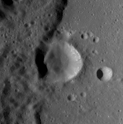
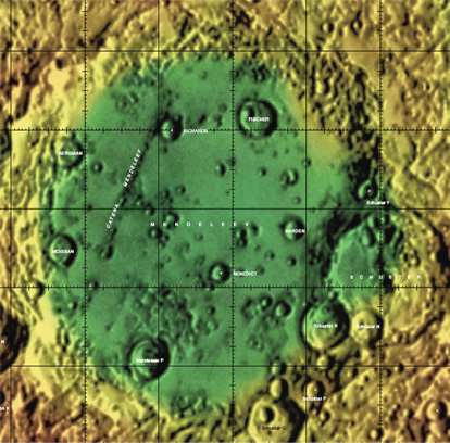
'''Left:''' ''[http://lroc.sese.asu.edu/index.html LROC]'' image WAC No. [http://wms.lroc.asu.edu/lroc/view_lroc/LRO-L-LROC-2-EDR-V1.0/M118953506ME M118953506ME]. Calibrated by [http://ltvt.wikispaces.com/Utility%20Programs#WAC_Viewer LROC_WAC_Previewer].<br /> '''Right:''' [http://planetarynames.wr.usgs.gov/images/Lunar/lac_66.pdf Color-coded LAC 66] from [[USGS%20Digital%20Atlas|USGS Digital Atlas]]<br /> <div id="toc"> | '''Left:''' ''[http://lroc.sese.asu.edu/index.html LROC]'' image WAC No. [http://wms.lroc.asu.edu/lroc/view_lroc/LRO-L-LROC-2-EDR-V1.0/M118953506ME M118953506ME]. Calibrated by [http://ltvt.wikispaces.com/Utility%20Programs#WAC_Viewer LROC_WAC_Previewer].<br /> '''Right:''' [http://planetarynames.wr.usgs.gov/images/Lunar/lac_66.pdf Color-coded LAC 66] from [[USGS%20Digital%20Atlas|USGS Digital Atlas]]<br /> <div id="toc"> | ||
| Line 21: | Line 21: | ||
''([[LAC%20zone|LAC zone]] 66D2)'' [http://www.lpi.usra.edu/resources/mapcatalog/LTO/lto66d2_1/ LTO map]<br /> <br /> | ''([[LAC%20zone|LAC zone]] 66D2)'' [http://www.lpi.usra.edu/resources/mapcatalog/LTO/lto66d2_1/ LTO map]<br /> <br /> | ||
==Description== | ==Description== | ||
| − | '''Bergman''' lies on the north-western side floor of the 330 km-wide [[Mendeleev|Mendeleev Basin]] of the [[stratigraphy|Nectarian]] period (3.92 - 3.85 bn years ago). The crater seems to have formed upon landslide material from said basin, and its floor looks unrelatively leveled - showing signs of a peak or scarp-like feature. <span class="membersnap">- | + | '''Bergman''' lies on the north-western side floor of the 330 km-wide [[Mendeleev|Mendeleev Basin]] of the [[stratigraphy|Nectarian]] period (3.92 - 3.85 bn years ago). The crater seems to have formed upon landslide material from said basin, and its floor looks unrelatively leveled - showing signs of a peak or scarp-like feature. <span class="membersnap">- JohnMoore2</span><br /> <br /> |
===Wikipedia=== | ===Wikipedia=== | ||
[http://en.wikipedia.org/wiki/Bergman_(crater) Bergman]<br /> <br /> | [http://en.wikipedia.org/wiki/Bergman_(crater) Bergman]<br /> <br /> | ||
| Line 27: | Line 27: | ||
* IAU page: [http://planetarynames.wr.usgs.gov/Feature/700 Bergman] | * IAU page: [http://planetarynames.wr.usgs.gov/Feature/700 Bergman] | ||
| − | * Depth data from [[Kurt%20Fisher% | + | * Depth data from [[Kurt%20Fisher%20Crater%20Depths|Kurt Fisher database]] |
** Pike, 1976: 2.7 km | ** Pike, 1976: 2.7 km | ||
<br /> | <br /> | ||
Latest revision as of 20:01, 16 April 2018
Contents
Bergman - on the floor of Mendeleev
| Lat: 7.38°N, Long: 137.76°E, Diam: 22.51 km, Depth: 2.7 km, Rükl: (farside) | |
Right: Color-coded LAC 66 from USGS Digital Atlas
Images
LPOD Photo Gallery Lunar Orbiter Images Apollo Images
Although the name Bergman is not included in the LPI's search-list of orbital Apollo photographs, it was photographed during several missions of project Apollo!- DannyCaes Jan 10, 2010.
- Apollo 16's orbital ITEK-panoramic frame AS16-P-4780 shows Bergman and its curious floor (with part of Mendeleev's western "multiple" rim running through it) about "halfway" into the frame.
- Apollo 16's ITEK-frame AS16-P-4948 shows Bergman's illuminated western inner slopes (in this frame, Bergman is the "next" crater rightward of Moissan, which is depicted near the frame's left margin).
- Two of Apollo 16's orbital Hasselblad color-photographs show close-ups of Bergman: AS16-118-18986 and AS16-118-18987.
- Research: Danny Caes
Maps
Description
Bergman lies on the north-western side floor of the 330 km-wide Mendeleev Basin of the Nectarian period (3.92 - 3.85 bn years ago). The crater seems to have formed upon landslide material from said basin, and its floor looks unrelatively leveled - showing signs of a peak or scarp-like feature. - JohnMoore2
Wikipedia
Additional Information
- IAU page: Bergman
- Depth data from Kurt Fisher database
- Pike, 1976: 2.7 km
Nomenclature
Torbern Olof; Swedish chemist, mineralogist, astronomer (1735-1784).
LPOD Articles
Bibliography
Named Features -- Prev: Benedict -- Next: Bergstrand

