Difference between revisions of "Yerkes"
| Line 6: | Line 6: | ||
|- | |- | ||
| | | | ||
| − | [http://www.lpod.org/coppermine/displayimage.php?pid=4920&fullsize=1 [[Image: | + | [http://www.lpod.org/coppermine/displayimage.php?pid=4920&fullsize=1 [[Image:Normal_yerkes.jpg|external image normal_yerkes.jpg]]]<br /> |
| | | | ||
| − | [http://www.lpod.org/coppermine/albums/userpics/Yerkes_LO-IV-191H_LTVT.JPG [[Image: | + | [http://www.lpod.org/coppermine/albums/userpics/Yerkes_LO-IV-191H_LTVT.JPG [[Image:Normal_Yerkes_LO-IV-191H_LTVT.JPG|external image normal_Yerkes_LO-IV-191H_LTVT.JPG]]]<br /> |
|} | |} | ||
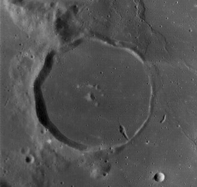
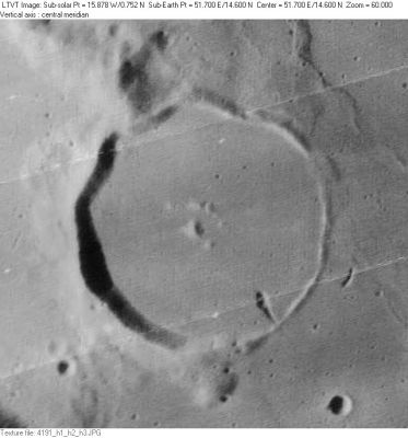
'''Left:''' '''Left:''' ''[http://lroc.sese.asu.edu/index.html LROC]'' image WAC No. [http://wms.lroc.asu.edu/lroc/view_lroc/LRO-L-LROC-2-EDR-V1.0/M119510188ME M119510188ME]. Calibrated by [http://ltvt.wikispaces.com/Utility%20Programs#WAC_Viewer LROC_WAC_Previewer].<br /> '''Right:''' ''[http://lpod.org/coppermine/displayimage.php?pos=-2552 LO-IV-191H]''<br /> <div id="toc"> | '''Left:''' '''Left:''' ''[http://lroc.sese.asu.edu/index.html LROC]'' image WAC No. [http://wms.lroc.asu.edu/lroc/view_lroc/LRO-L-LROC-2-EDR-V1.0/M119510188ME M119510188ME]. Calibrated by [http://ltvt.wikispaces.com/Utility%20Programs#WAC_Viewer LROC_WAC_Previewer].<br /> '''Right:''' ''[http://lpod.org/coppermine/displayimage.php?pos=-2552 LO-IV-191H]''<br /> <div id="toc"> | ||
| Line 22: | Line 22: | ||
==Additional Information== | ==Additional Information== | ||
* IAU page: [http://planetarynames.wr.usgs.gov/Feature/6658 Yerkes] | * IAU page: [http://planetarynames.wr.usgs.gov/Feature/6658 Yerkes] | ||
| − | * Depth data from [[Kurt%20Fisher% | + | * Depth data from [[Kurt%20Fisher%20Crater%20Depths|Kurt Fisher database]] |
** Pike, 1976: 0.62 km | ** Pike, 1976: 0.62 km | ||
** Westfall, 2000: 0.62 km | ** Westfall, 2000: 0.62 km | ||
Latest revision as of 02:23, 16 April 2018
Contents
Yerkes (at the WSW part of Mare Crisium)
|
Lat: 14.57°N, Long: 51.7°E, Diam: 35.66 km, Depth: 0.62 km, Rükl: 26 | |
Right: LO-IV-191H
Images
LPOD Photo Gallery Lunar Orbiter Images Apollo Images
Maps
(LAC zone 62A1) LAC map Geologic map LM map LTO map
Description
Wikipedia
Additional Information
- IAU page: Yerkes
- Depth data from Kurt Fisher database
- Pike, 1976: 0.62 km
- Westfall, 2000: 0.62 km
Nomenclature
- Named for Charles Tyson Yerkes (June 25, 1837 – December 29, 1905), an American financier. Yerkes decided in 1892 to bankroll the world's largest telescope after being lobbied by the astronomer George Ellery Hale and University of Chicago president William Rainey Harper. He would contribute nearly $300,000 to the University of Chicago to establish what would become known as the Yerkes Observatory, located in Williams Bay, Wisconsin. Although designed for visual use, Ritchey used the Yerkes instruments to photograph the Moon and other objects starting in 1900.
- Rimae Yerkes (an unofficial name from an explorer of all sorts of lunar surface features for the cluster of rilles west-northwest of Yerkes).
LPOD Articles
Bibliography
Named Features -- Prev: Rima Yangel' -- Next: Yoshi

