Difference between revisions of "Pons"
(Created page with "<div id="content_view" class="wiki" style="display: block"> =Pons= {| class="wiki_table" | Lat: 25.3°S, Long: 21.5°E, Diam: 41 km, Depth: 1.96 km, [/R%C3%BCkl%2057 Rükl...") |
|||
| (2 intermediate revisions by the same user not shown) | |||
| Line 3: | Line 3: | ||
{| class="wiki_table" | {| class="wiki_table" | ||
| | | | ||
| − | Lat: 25.3°S, Long: 21.5°E, Diam: 41 km, Depth: 1.96 km, [ | + | Lat: 25.3°S, Long: 21.5°E, Diam: 41 km, Depth: 1.96 km, [[R%C3%BCkl%2057|Rükl: 57]]<br /> |
|} | |} | ||
<div id="toc"> | <div id="toc"> | ||
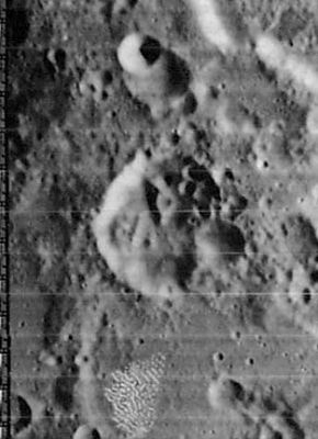
| − | + | [http://www.lpod.org/coppermine/displayimage.php?pid=2016&fullsize=1 [[Image:Normal_Pons_LO_iv_084_h1.jpg|external image normal_Pons_LO_iv_084_h1.jpg]]]<br /> ''[http://lpod.org/coppermine/displayimage.php?pos=-2016 LOIV 084 H1]''<br /> <br /> | |
| − | |||
==Images== | ==Images== | ||
[http://www.lpod.org/coppermine/thumbnails.php?album=search&type=full&search=Pons LPOD Photo Gallery] [http://www.lpi.usra.edu/resources/lunar_orbiter/bin/srch_nam.shtml?Pons%7C0 Lunar Orbiter Images] [http://www.lpi.usra.edu/resources/apollo/search/feature/?feature=Pons Apollo Images]<br /> Was crater '''Pons''' captured on orbital photographs made during Project Apollo?<br /> Perhaps... at the centre of the curved horizon in Apollo 16's oblique south looking Mapping/Metric ''Fairchild'' camera frame [http://www.lpi.usra.edu/resources/apollo/images/print/AS16/M/0696.jpg AS16-M-0696] (slightly south of the northern part of '''Rupes Altai''').<br /> Research Danny Caes<br /> <br /> <br /> | [http://www.lpod.org/coppermine/thumbnails.php?album=search&type=full&search=Pons LPOD Photo Gallery] [http://www.lpi.usra.edu/resources/lunar_orbiter/bin/srch_nam.shtml?Pons%7C0 Lunar Orbiter Images] [http://www.lpi.usra.edu/resources/apollo/search/feature/?feature=Pons Apollo Images]<br /> Was crater '''Pons''' captured on orbital photographs made during Project Apollo?<br /> Perhaps... at the centre of the curved horizon in Apollo 16's oblique south looking Mapping/Metric ''Fairchild'' camera frame [http://www.lpi.usra.edu/resources/apollo/images/print/AS16/M/0696.jpg AS16-M-0696] (slightly south of the northern part of '''Rupes Altai''').<br /> Research Danny Caes<br /> <br /> <br /> | ||
==Maps== | ==Maps== | ||
| − | ''([ | + | ''([[LAC%20zone|LAC zone]] 96C1)'' [http://www.lpi.usra.edu/resources/mapcatalog/LAC/lac96/ LAC map] [http://www.lpi.usra.edu/resources/mapcatalog/usgs/I690/ Geologic map]<br /> <br /> |
==Description== | ==Description== | ||
<br /> | <br /> | ||
==Description: Elger== | ==Description: Elger== | ||
| − | ''([ | + | ''([[IAU%20directions|IAU Directions]])'' PONS.--A complete formation of irregular shape, about 20 miles in greatest diameter, on the S.W. side of the [[Rupes%20Altai|Altai range]], in E. long. 21 deg. It consists of a crowd of rings and craters enclosed by a narrow wall.<br /> <br /> |
==Description: Wikipedia== | ==Description: Wikipedia== | ||
[http://en.wikipedia.org/wiki/Pons_(crater) Pons]<br /> <br /> | [http://en.wikipedia.org/wiki/Pons_(crater) Pons]<br /> <br /> | ||
==Additional Information== | ==Additional Information== | ||
| − | Depth data from [ | + | Depth data from [[Kurt%20Fisher%20Crater%20Depths|Kurt Fisher database]]<br /> |
* Westfall, 2000: 1.96 km | * Westfall, 2000: 1.96 km | ||
* Cherrington, 1969: 2.28 km | * Cherrington, 1969: 2.28 km | ||
| − | * Satellite craters Pons B, E and M are on the [ | + | * Satellite craters Pons B, E and M are on the [[ALPO%20list%20of%20bright%20ray%20craters|ALPO list of bright ray craters]]. |
| − | * Satellite crater Pons F is on the [ | + | * Satellite crater Pons F is on the [[ALPO%20list%20of%20banded%20craters|ALPO list of banded craters]] |
==Nomenclature== | ==Nomenclature== | ||
[http://en.wikipedia.org/wiki/Jean-Louis_Pons Jean-Louis Pons] (December 24, 1761 – October 14, 1831) was a French astronomer. Between 1801 and 1827 Pons discovered thirty-seven comets, more than any other person in history. He also discovered four periodic comets.<br /> <br /> | [http://en.wikipedia.org/wiki/Jean-Louis_Pons Jean-Louis Pons] (December 24, 1761 – October 14, 1831) was a French astronomer. Between 1801 and 1827 Pons discovered thirty-seven comets, more than any other person in history. He also discovered four periodic comets.<br /> <br /> | ||
| Line 32: | Line 31: | ||
<br /> <br /> | <br /> <br /> | ||
---- | ---- | ||
| − | + | </div> | |
Latest revision as of 02:09, 16 April 2018
Contents
Pons
|
Lat: 25.3°S, Long: 21.5°E, Diam: 41 km, Depth: 1.96 km, Rükl: 57 |
Images
LPOD Photo Gallery Lunar Orbiter Images Apollo Images
Was crater Pons captured on orbital photographs made during Project Apollo?
Perhaps... at the centre of the curved horizon in Apollo 16's oblique south looking Mapping/Metric Fairchild camera frame AS16-M-0696 (slightly south of the northern part of Rupes Altai).
Research Danny Caes
Maps
(LAC zone 96C1) LAC map Geologic map
Description
Description: Elger
(IAU Directions) PONS.--A complete formation of irregular shape, about 20 miles in greatest diameter, on the S.W. side of the Altai range, in E. long. 21 deg. It consists of a crowd of rings and craters enclosed by a narrow wall.
Description: Wikipedia
Additional Information
Depth data from Kurt Fisher database
- Westfall, 2000: 1.96 km
- Cherrington, 1969: 2.28 km
- Satellite craters Pons B, E and M are on the ALPO list of bright ray craters.
- Satellite crater Pons F is on the ALPO list of banded craters
Nomenclature
Jean-Louis Pons (December 24, 1761 – October 14, 1831) was a French astronomer. Between 1801 and 1827 Pons discovered thirty-seven comets, more than any other person in history. He also discovered four periodic comets.
LPOD Articles
Bibliography
