Difference between revisions of "Kasper"
(Created page with "<div id="content_view" class="wiki" style="display: block"> =Kasper= {| class="wiki_table" | Lat: 8.3°N, Long: 122.1°E, Diam: 12 km, Depth: km, Rükl: ''(farside)''<br />...") |
|||
| (2 intermediate revisions by the same user not shown) | |||
| Line 5: | Line 5: | ||
|} | |} | ||
<div id="toc"> | <div id="toc"> | ||
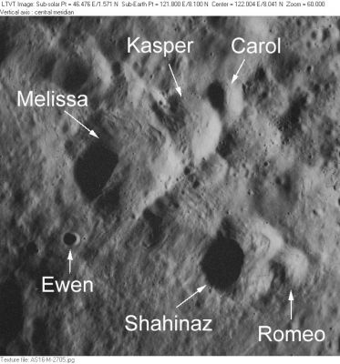
| − | + | [http://www.lpod.org/coppermine/albums/userpics/Melissa_AS16-M-2705_LTVT.JPG [[Image:Normal_Melissa_AS16-M-2705_LTVT.JPG|external image normal_Melissa_AS16-M-2705_LTVT.JPG]]]<br /> ''[http://lpod.org/coppermine/displayimage.php?pos=-2360 Apollo AS16-M-2705]'' This intensely-mapped area between [[Ibn%20Firnas|Ibn Firnas]] and [[Ostwald|Ostwald]] includes IAU-approved minor feature names [[Melissa|Melissa]], [[Kasper|Kasper]], [[Carol|Carol]], [[Ewen|Ewen]], [[Shahinaz|Shahinaz]] and [[Romeo|Romeo]].<br /> <br /> | |
| − | |||
==Images== | ==Images== | ||
[http://www.lpod.org/coppermine/thumbnails.php?album=search&type=full&search=Kasper LPOD Photo Gallery] [http://www.lpi.usra.edu/resources/lunar_orbiter/bin/srch_nam.shtml?Ostwald%7C0 Lunar Orbiter Images] [http://www.lpi.usra.edu/resources/apollo/search/feature/?feature=Ostwald Apollo Images]<br /> <br /> | [http://www.lpod.org/coppermine/thumbnails.php?album=search&type=full&search=Kasper LPOD Photo Gallery] [http://www.lpi.usra.edu/resources/lunar_orbiter/bin/srch_nam.shtml?Ostwald%7C0 Lunar Orbiter Images] [http://www.lpi.usra.edu/resources/apollo/search/feature/?feature=Ostwald Apollo Images]<br /> <br /> | ||
==Maps== | ==Maps== | ||
| − | ''([ | + | ''([[LAC%20zone|LAC zone]] 65B4)'' [http://www.lpi.usra.edu/resources/mapcatalog/LTO/lto65b4_1/ LTO map] [http://www.lpi.usra.edu/resources/mapcatalog/topophoto/65C1S2/ Topophotomap]<br /> <br /> |
==Description== | ==Description== | ||
<br /> | <br /> | ||
| Line 19: | Line 18: | ||
==Nomenclature== | ==Nomenclature== | ||
Polish male name.<br /> | Polish male name.<br /> | ||
| − | * According to [ | + | * According to [[NASA%20RP-1097|NASA RP-1097]], "'''Kasper'''" is a [[Minor%20Feature|Minor Feature]] whose name was originally intended only for use in connection with [http://www.lpi.usra.edu/resources/mapcatalog/topophoto/65C1S2/ Topophotomap 65C1/S2](on which it is plotted). |
* '''Kasper''' (as '''''Casper''''') was also the call-name of Apollo 16's CSM (Command-Service Module), manned by Ken Mattingly (CMP - Command Module Pilot) while in orbit around the moon during the landing of Lunar Module '''''Orion''''' and the surface excursions of John Young (CDR - Commander) and Charles Duke (LMP - Lunar Module Pilot) aboard the LRV (Lunar Roving Vehicle) at the '''Descartes''' region near both the '''North Ray''' and '''South Ray''' (a couple of high albedo craterlets which are observable during Full Moon). Aboard the CSM '''Casper''', Ken Mattingly performed the task of photographing lunar near-the-equator areas with High-Resolution cameras from the SIM-bay (Scientific Instruments Module - bay) of '''Casper''''s Service Module. The mission of Apollo 16 happened in April 1972. | * '''Kasper''' (as '''''Casper''''') was also the call-name of Apollo 16's CSM (Command-Service Module), manned by Ken Mattingly (CMP - Command Module Pilot) while in orbit around the moon during the landing of Lunar Module '''''Orion''''' and the surface excursions of John Young (CDR - Commander) and Charles Duke (LMP - Lunar Module Pilot) aboard the LRV (Lunar Roving Vehicle) at the '''Descartes''' region near both the '''North Ray''' and '''South Ray''' (a couple of high albedo craterlets which are observable during Full Moon). Aboard the CSM '''Casper''', Ken Mattingly performed the task of photographing lunar near-the-equator areas with High-Resolution cameras from the SIM-bay (Scientific Instruments Module - bay) of '''Casper''''s Service Module. The mission of Apollo 16 happened in April 1972. | ||
<br /> | <br /> | ||
| Line 27: | Line 26: | ||
<br /> <br /> | <br /> <br /> | ||
---- | ---- | ||
| − | + | </div> | |
Latest revision as of 01:55, 16 April 2018
Contents
Kasper
| Lat: 8.3°N, Long: 122.1°E, Diam: 12 km, Depth: km, Rükl: (farside) |
Apollo AS16-M-2705 This intensely-mapped area between Ibn Firnas and Ostwald includes IAU-approved minor feature names Melissa, Kasper, Carol, Ewen, Shahinaz and Romeo.
Images
LPOD Photo Gallery Lunar Orbiter Images Apollo Images
Maps
(LAC zone 65B4) LTO map Topophotomap
Description
Description: Wikipedia
Additional Information
Nomenclature
Polish male name.
- According to NASA RP-1097, "Kasper" is a Minor Feature whose name was originally intended only for use in connection with Topophotomap 65C1/S2(on which it is plotted).
- Kasper (as Casper) was also the call-name of Apollo 16's CSM (Command-Service Module), manned by Ken Mattingly (CMP - Command Module Pilot) while in orbit around the moon during the landing of Lunar Module Orion and the surface excursions of John Young (CDR - Commander) and Charles Duke (LMP - Lunar Module Pilot) aboard the LRV (Lunar Roving Vehicle) at the Descartes region near both the North Ray and South Ray (a couple of high albedo craterlets which are observable during Full Moon). Aboard the CSM Casper, Ken Mattingly performed the task of photographing lunar near-the-equator areas with High-Resolution cameras from the SIM-bay (Scientific Instruments Module - bay) of Casper's Service Module. The mission of Apollo 16 happened in April 1972.
LPOD Articles
Bibliography
