Difference between revisions of "Byrd"
| (One intermediate revision by the same user not shown) | |||
| Line 7: | Line 7: | ||
|} | |} | ||
<div id="toc"> | <div id="toc"> | ||
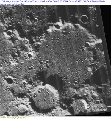
| − | + | [http://www.lpod.org/coppermine/albums/userpics/Byrd_LO-IV-190H.JPG [[Image:Normal_Byrd_LO-IV-190H.JPG|external image normal_Byrd_LO-IV-190H.JPG]]]<br /> ''[http://lpod.org/coppermine/displayimage.php?pos=-1652 LO-IV-190H]'' '''Byrd''' is the large crater at center, with the smaller [[Gioja|Gioja]] at the bottom, to the left of center. <br /> <br /> | |
| − | |||
==Images== | ==Images== | ||
[http://www.lpod.org/coppermine/thumbnails.php?album=search&type=full&search=Byrd LPOD Photo Gallery] [http://www.lpi.usra.edu/resources/lunar_orbiter/bin/srch_nam.shtml?Byrd%7C0 Lunar Orbiter Images]<br /> <br /> | [http://www.lpod.org/coppermine/thumbnails.php?album=search&type=full&search=Byrd LPOD Photo Gallery] [http://www.lpi.usra.edu/resources/lunar_orbiter/bin/srch_nam.shtml?Byrd%7C0 Lunar Orbiter Images]<br /> <br /> | ||
| Line 18: | Line 17: | ||
[http://en.wikipedia.org/wiki/Byrd_(crater) Byrd]<br /> <br /> | [http://en.wikipedia.org/wiki/Byrd_(crater) Byrd]<br /> <br /> | ||
==Additional Information== | ==Additional Information== | ||
| − | * Depth data from [[Kurt%20Fisher% | + | * Depth data from [[Kurt%20Fisher%20Crater%20Depths|Kurt Fisher database]] |
** Westfall, 2000: 1.38 km | ** Westfall, 2000: 1.38 km | ||
** Cherrington, 1969: 2.59 km | ** Cherrington, 1969: 2.59 km | ||
| − | * In [http://www.lpi.usra.edu/resources/lunarorbiter/frame/?4190 LO-IV-190H], the shadows from [[Gioja|Gioja]] (to the south) drop about 2,150 m onto the floor of Byrd. The ridge on the east rises about 2,500 above the terrain at its shadow's tip. <span class="membersnap">- | + | * In [http://www.lpi.usra.edu/resources/lunarorbiter/frame/?4190 LO-IV-190H], the shadows from [[Gioja|Gioja]] (to the south) drop about 2,150 m onto the floor of Byrd. The ridge on the east rises about 2,500 above the terrain at its shadow's tip. <span class="membersnap">- Jim Mosher</span> |
<br /> | <br /> | ||
==Nomenclature== | ==Nomenclature== | ||
| Line 35: | Line 34: | ||
<br /> <br /> | <br /> <br /> | ||
---- | ---- | ||
| − | + | </div> | |
Latest revision as of 01:43, 16 April 2018
Contents
Byrd
(formerly Gioja A)
|
Lat: 85.3°N, Long: 9.8°E, Diam: 93 km, Depth: 1.38 km, Rükl: 4, pre-Nectarian |
LO-IV-190H Byrd is the large crater at center, with the smaller Gioja at the bottom, to the left of center.
Images
LPOD Photo Gallery Lunar Orbiter Images
Maps
(LAC zone 1A4) USGS Digital Atlas PDF
Description
Description: Wikipedia
Additional Information
- Depth data from Kurt Fisher database
- Westfall, 2000: 1.38 km
- Cherrington, 1969: 2.59 km
- In LO-IV-190H, the shadows from Gioja (to the south) drop about 2,150 m onto the floor of Byrd. The ridge on the east rises about 2,500 above the terrain at its shadow's tip. - Jim Mosher
Nomenclature
- Named for Rear Admiral Richard Evelyn Byrd, USN (October 25, 1888 – March 11, 1957), a pioneering American polar explorer and famous aviator. By the time Byrd died he had amassed twenty-two citations and special commendations, nine of which were for bravery and two for extraordinary heroism in saving the lives of others. As well he earned the Medal of Honor, the Congressional Life Saving Medal, the Navy Distinguished Service Medal, the Distinguished Flying Cross, the Navy Cross and three ticker-tape parades.
- The name Gioja A was inserted as Catalog number 1018a in the original IAU nomenclature of Named Lunar Formations.
- Wilkins and Moore proposed the replacement name Shackleton for Gioja A but the IAU did not accept that name, assigning it instead to a crater at the moon's SOUTH pole!
- The replacement name Byrd was given by Arthur and Whitaker in the Rectified Lunar Atlas (1963) and approved by the IAU in 1964.
LPOD Articles
Over the Pole
Back to the Pole
Bibliography
