Difference between revisions of "Manilius"
| Line 11: | Line 11: | ||
|} | |} | ||
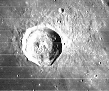
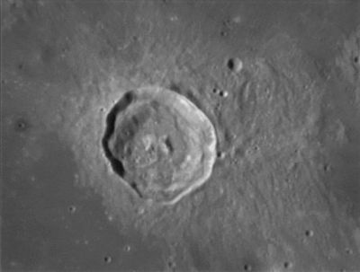
'''Left''': ''[http://lpod.org/coppermine/displayimage.php?pos=-136 LO-IV-097-H2]'' from Paolo Amoroso '''Right''': ''[http://lpod.org/coppermine/displayimage.php?pos=-2937 François Emond]'' The 5-km diameter crater to the northeast is '''Manilius G'''<br /> <br /> <div id="toc"> | '''Left''': ''[http://lpod.org/coppermine/displayimage.php?pos=-136 LO-IV-097-H2]'' from Paolo Amoroso '''Right''': ''[http://lpod.org/coppermine/displayimage.php?pos=-2937 François Emond]'' The 5-km diameter crater to the northeast is '''Manilius G'''<br /> <br /> <div id="toc"> | ||
| − | + | ||
| − | |||
==Images== | ==Images== | ||
| − | [http://www.lpod.org/coppermine/thumbnails.php?album=search&type=full&search=Manilius LPOD Photo Gallery] [http://www.lpi.usra.edu/resources/lunar_orbiter/bin/srch_nam.shtml?Manilius%7C0 Lunar Orbiter Images] [http://www.lpi.usra.edu/resources/apollo/search/feature/?feature=Manilius Apollo Images]<br /> <u>'''Warning'''</u>: several orbital photographs of '''Manilius''' and environs, made with Apollo 15's panoramic ''ITEK''-camera, are online in the LPI's ''Apollo Image Atlas'' as "[http://www.lpi.usra.edu/resources/apollo/search/feature/?feature=Manilus&sort= Manilus]" instead of '''Manilius'''. <span class="membersnap">- | + | [http://www.lpod.org/coppermine/thumbnails.php?album=search&type=full&search=Manilius LPOD Photo Gallery] [http://www.lpi.usra.edu/resources/lunar_orbiter/bin/srch_nam.shtml?Manilius%7C0 Lunar Orbiter Images] [http://www.lpi.usra.edu/resources/apollo/search/feature/?feature=Manilius Apollo Images]<br /> <u>'''Warning'''</u>: several orbital photographs of '''Manilius''' and environs, made with Apollo 15's panoramic ''ITEK''-camera, are online in the LPI's ''Apollo Image Atlas'' as "[http://www.lpi.usra.edu/resources/apollo/search/feature/?feature=Manilus&sort= Manilus]" instead of '''Manilius'''. <span class="membersnap">- DannyCaes <small>Feb 17, 2012</small></span><br /> - Apollo 15's panoramic ''ITEK''-camera frame [http://www.lpi.usra.edu/resources/apollo/frame/?AS15-P-10169 AS15-P-10169] shows a close up of the unnamed dark halo crater immediately west of '''Manilius'''.<br /> Research: Danny Caes<br /> <br /> |
==Maps== | ==Maps== | ||
''([http://the-moon.us/wiki/LAC%20zone LAC zone] 59B2)'' [http://www.lpi.usra.edu/resources/mapcatalog/LAC/lac59/ LAC map] [http://www.lpi.usra.edu/resources/mapcatalog/usgs/I548/ Geologic map]<br /> <br /> | ''([http://the-moon.us/wiki/LAC%20zone LAC zone] 59B2)'' [http://www.lpi.usra.edu/resources/mapcatalog/LAC/lac59/ LAC map] [http://www.lpi.usra.edu/resources/mapcatalog/usgs/I548/ Geologic map]<br /> <br /> | ||
| Line 54: | Line 53: | ||
<br /> <br /> | <br /> <br /> | ||
---- | ---- | ||
| − | + | </div> | |
Revision as of 17:36, 15 April 2018
Contents
[hide]Manilius
|
Lat: 14.5°N, Long: 9.1°E, Diam: 38 km, Depth: 3.06 km, Rükl: 23, Eratosthenian | |
Images
LPOD Photo Gallery Lunar Orbiter Images Apollo Images
Warning: several orbital photographs of Manilius and environs, made with Apollo 15's panoramic ITEK-camera, are online in the LPI's Apollo Image Atlas as "Manilus" instead of Manilius. - DannyCaes Feb 17, 2012
- Apollo 15's panoramic ITEK-camera frame AS15-P-10169 shows a close up of the unnamed dark halo crater immediately west of Manilius.
Research: Danny Caes
Maps
(LAC zone 59B2) LAC map Geologic map
Description
Description: Elger
(IAU Directions) MANILIUS.--This, one of the most brilliant objects in the first quadrant, is about 25 miles in diameter, with walls nearly 8000 feet above the floor, which includes a bright central mountain. The inner slope of the border on the W. is much terraced and contains some depressions. There is a small isolated bright mountain 2000 feet high on the Mare Vaporum, some distance to the W.
Description: Wikipedia
Additional Information
- Depth data from Kurt Fisher database
- Arthur, 1974: 3.06 km
- Westfall, 2000: 3.06 km
- Viscardy, 1985: 3.1 km
- Cherrington, 1969: 2.83 km
- Central peak composition: A (Tompkins & Pieters, 1999)
- A dark-halo craterlet slightly west of Manilius was captured on Hasselblad image AS15-93-12683. This dark-halo craterlet is a good test object for telescopic observers of the Full Moon. Research: Danny Caes.
- Included in ALPO list of bright ray craters
- TSI = 30, CPI = 15, FI = 25; MI =70 Smith and Sanchez, 1973
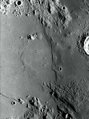
- Manilius domes in the region (a slice of Manilius crater is seen on right edge of image).

- LROC mosaic image from both WAC No. M116282898ME and WAC No. M116269338ME (unofficial image, stacked using the LROC_WAC_Previewer software - - JohnMoore2 JohnMoore2).
Manilius 1 and Manilius 2 (Irregular Mare Patches -IMPs- west of Manilius)
- Manilius 1 (number 30 in the catalog of 70 IMPs) is detectable at Latitude 14.889 / Longitude 6.467.
- Manilius 2 (number 37) is detectable at Latitude 14.628 / Longitude 6.821.
- Warning: both Manilius 1 and 2 are very small formations. The diameter of Manilius 1 is 270 meters, Manilius 2 is 200 meters.
Nomenclature
- Named for Marcus Manilius (fl. 1st century AD), a Roman poet, astrologer, and author of a poem in five books called Astronomica.
- This name has continued unchanged since its original usage for this feature on Riccioli's map (Whitaker, p. 213).
- An officially unnamed rille just south of Manilius is called Rima Pau by the dedicated moon observer K.C.Pau.
LPOD Articles
Bibliography

