Difference between revisions of "Wurzelbauer"
| Line 3: | Line 3: | ||
{| class="wiki_table" | {| class="wiki_table" | ||
| | | | ||
| − | Lat: 33.9°S, Long: 15.9°W, Diam: 88 km, Depth: 2.77 km, [ | + | Lat: 33.9°S, Long: 15.9°W, Diam: 88 km, Depth: 2.77 km, [[R%C3%BCkl%2064|Rükl: 64]]<br /> |
|} | |} | ||
<div id="toc"> | <div id="toc"> | ||
| Line 11: | Line 11: | ||
[http://www.lpod.org/coppermine/thumbnails.php?album=search&type=full&search=Wurzelbauer LPOD Photo Gallery] [http://www.lpi.usra.edu/resources/lunar_orbiter/bin/srch_nam.shtml?Wurzelbauer%7C0 Lunar Orbiter Images] [http://www.lpi.usra.edu/resources/apollo/search/feature/?feature=Wurzelbauer Apollo Images]<br /> <br /> | [http://www.lpod.org/coppermine/thumbnails.php?album=search&type=full&search=Wurzelbauer LPOD Photo Gallery] [http://www.lpi.usra.edu/resources/lunar_orbiter/bin/srch_nam.shtml?Wurzelbauer%7C0 Lunar Orbiter Images] [http://www.lpi.usra.edu/resources/apollo/search/feature/?feature=Wurzelbauer Apollo Images]<br /> <br /> | ||
==Maps== | ==Maps== | ||
| − | ''([ | + | ''([[LAC%20zone|LAC zone]] 111B2)'' [http://www.lpi.usra.edu/resources/mapcatalog/LAC/lac111/ LAC map] [http://www.lpi.usra.edu/resources/mapcatalog/usgs/I824/ Geologic map]<br /> <br /> |
==Description== | ==Description== | ||
<br /> | <br /> | ||
==Description: Elger== | ==Description: Elger== | ||
| − | ''([ | + | ''([[IAU%20Directions|IAU Directions]])'' WURZELBAUER.--Another irregular walled-plain, about 50 miles in diameter, on the S.W. of [[Pitatus|Pitatus]], with a very complex border, in connection with which, on the S.E., is a group of fine depressions, and on the S.W. a large crater. There is much detail on the very uneven floor.<br /> <br /> |
==Description: Wikipedia== | ==Description: Wikipedia== | ||
[http://en.wikipedia.org/wiki/Wurzelbauer_(crater) Wurzelbauer]<br /> <br /> | [http://en.wikipedia.org/wiki/Wurzelbauer_(crater) Wurzelbauer]<br /> <br /> | ||
==Additional Information== | ==Additional Information== | ||
| − | Depth data from [ | + | Depth data from [[Kurt%20Fisher%20crater%20depths|Kurt Fisher database]]<br /> |
* Westfall, 2000: 2.77 km | * Westfall, 2000: 2.77 km | ||
* Cherrington, 1969: 2.19 km | * Cherrington, 1969: 2.19 km | ||
| Line 26: | Line 26: | ||
* [http://en.wikipedia.org/wiki/Johann_Philipp_von_Wurzelbauer Johann Philipp von Wurzelbauer] (1651-1725) was a German astronomer. He first published a work concerning his observations on the great comet of 1680. After 1682, Wurzelbauer owned his own astronomical observatory and instruments, and observed the transit of Mercury, solar eclipses, and worked out the geographical latitude of his native city. | * [http://en.wikipedia.org/wiki/Johann_Philipp_von_Wurzelbauer Johann Philipp von Wurzelbauer] (1651-1725) was a German astronomer. He first published a work concerning his observations on the great comet of 1680. After 1682, Wurzelbauer owned his own astronomical observatory and instruments, and observed the transit of Mercury, solar eclipses, and worked out the geographical latitude of his native city. | ||
| − | * According to ''[ | + | * According to ''[[Whitaker|Whitaker]]'' (p. 218), this name was introduced by [[Schr%C3%B6ter|Schröter]]. |
* Crater '''Wurzelbauer D''' was called '''Hauet''' by Hugh Percy Wilkins and Patrick Moore, but the I.A.U. did not accept that name. | * Crater '''Wurzelbauer D''' was called '''Hauet''' by Hugh Percy Wilkins and Patrick Moore, but the I.A.U. did not accept that name. | ||
* Hauet was a French selenographer (1878-1933). | * Hauet was a French selenographer (1878-1933). | ||
| Line 33: | Line 33: | ||
[http://www2.lpod.org/wiki/January_24,_2007 One or Two Craters] [http://lpod.wikispaces.com/April+18%2C+2009 D] (Wurzelbauer D)<br /> <br /> | [http://www2.lpod.org/wiki/January_24,_2007 One or Two Craters] [http://lpod.wikispaces.com/April+18%2C+2009 D] (Wurzelbauer D)<br /> <br /> | ||
==Bibliography== | ==Bibliography== | ||
| − | Wurzelbauer D ("Hauet"): [ | + | Wurzelbauer D ("Hauet"): [[Wilkins%20and%20Moore|THE MOON]] by H.P.Wilkins and P.Moore.<br /> <br /> |
---- | ---- | ||
This page has been edited 1 times. The last modification was made by <span class="membersnap">- [http://www.wikispaces.com/user/view/tychocrater [[Image:tychocrater-lg.jpg|16px|tychocrater]]] [http://www.wikispaces.com/user/view/tychocrater tychocrater]</span> on Jun 13, 2009 3:24 pm - ''afx3u2''</div> | This page has been edited 1 times. The last modification was made by <span class="membersnap">- [http://www.wikispaces.com/user/view/tychocrater [[Image:tychocrater-lg.jpg|16px|tychocrater]]] [http://www.wikispaces.com/user/view/tychocrater tychocrater]</span> on Jun 13, 2009 3:24 pm - ''afx3u2''</div> | ||
Revision as of 15:23, 15 April 2018
Contents
Wurzelbauer
|
Lat: 33.9°S, Long: 15.9°W, Diam: 88 km, Depth: 2.77 km, Rükl: 64 |
Table of Contents
[#Wurzelbauer Wurzelbauer]
[#Wurzelbauer-Images Images]
[#Wurzelbauer-Maps Maps]
[#Wurzelbauer-Description Description]
[#Wurzelbauer-Description: Elger Description: Elger]
[#Wurzelbauer-Description: Wikipedia Description: Wikipedia]
[#Wurzelbauer-Additional Information Additional Information]
[#Wurzelbauer-Nomenclature Nomenclature]
[#Wurzelbauer-LPOD Articles LPOD Articles]
[#Wurzelbauer-Bibliography Bibliography]

François Emond
Images
LPOD Photo Gallery Lunar Orbiter Images Apollo Images
Maps
(LAC zone 111B2) LAC map Geologic map
Description
Description: Elger
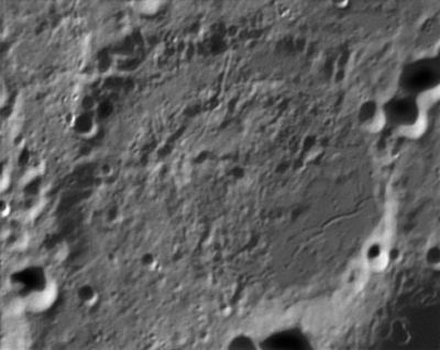
(IAU Directions) WURZELBAUER.--Another irregular walled-plain, about 50 miles in diameter, on the S.W. of Pitatus, with a very complex border, in connection with which, on the S.E., is a group of fine depressions, and on the S.W. a large crater. There is much detail on the very uneven floor.
Description: Wikipedia
Additional Information
Depth data from Kurt Fisher database
- Westfall, 2000: 2.77 km
- Cherrington, 1969: 2.19 km
A Pareidolia is frequently observed on the floor of Wurzelbauer, looking like a face. Source: several telescopic observers of the Wurzelbauer region.
Nomenclature
- Johann Philipp von Wurzelbauer (1651-1725) was a German astronomer. He first published a work concerning his observations on the great comet of 1680. After 1682, Wurzelbauer owned his own astronomical observatory and instruments, and observed the transit of Mercury, solar eclipses, and worked out the geographical latitude of his native city.
- According to Whitaker (p. 218), this name was introduced by Schröter.
- Crater Wurzelbauer D was called Hauet by Hugh Percy Wilkins and Patrick Moore, but the I.A.U. did not accept that name.
- Hauet was a French selenographer (1878-1933).
LPOD Articles
One or Two Craters D (Wurzelbauer D)
Bibliography
Wurzelbauer D ("Hauet"): THE MOON by H.P.Wilkins and P.Moore.
This page has been edited 1 times. The last modification was made by - tychocrater tychocrater on Jun 13, 2009 3:24 pm - afx3u2