Difference between revisions of "Serenitatis, Mare"
| Line 8: | Line 8: | ||
<br /> <u>Named for</u><br /> "Sea of Serenity".<br /> <br /> <u>LPOD Articles</u><br /> [http://www2.lpod.org/wiki/August_27,_2004 Serenitatis in Black and White and Gray]<br /> [http://www2.lpod.org/wiki/May_1,_2004 Serenitatis Diameter Sequence]<br /> [http://www2.lpod.org/wiki/February_7,_2004 Crumpled Sheets of Lava]<br /> [http://www2.lpod.org/wiki/February_17,_2007 Make Your Own Atlas]<br /> <br /> <u>Bibliography</u><br /> <br /> <br /> | <br /> <u>Named for</u><br /> "Sea of Serenity".<br /> <br /> <u>LPOD Articles</u><br /> [http://www2.lpod.org/wiki/August_27,_2004 Serenitatis in Black and White and Gray]<br /> [http://www2.lpod.org/wiki/May_1,_2004 Serenitatis Diameter Sequence]<br /> [http://www2.lpod.org/wiki/February_7,_2004 Crumpled Sheets of Lava]<br /> [http://www2.lpod.org/wiki/February_17,_2007 Make Your Own Atlas]<br /> <br /> <u>Bibliography</u><br /> <br /> <br /> | ||
---- | ---- | ||
| − | + | </div> | |
Revision as of 17:51, 15 April 2018
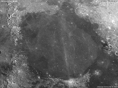
Mare Serenitatis
| Lat: 28.0°N, Long: 17.5°E, Diam: 707 km, Depth: 2.5 km, Rükl: 23 |

George Tarsoudis
Images
LPOD|Photo Gallery images Lunar Orbiter Images Apollo Images
Maps (LAC zone 42A3)
LAC map Geologic map LM map LTO map
Description
Description: Wikipedia
Mare Serenitatis
Additional Information
Depth data from Kurt Fisher database
- Pike, 1976: 2.5 km
Named for
"Sea of Serenity".
LPOD Articles
Serenitatis in Black and White and Gray
Serenitatis Diameter Sequence
Crumpled Sheets of Lava
Make Your Own Atlas
Bibliography