Rimae Taruntius
Contents
Rimae Taruntius
(unofficially known as Fossae Taruntius)
|
Lat: 5.5°N, Long: 46.5°E, Length: 25 km, Depth: km, [/R%C3%BCkl%2037 Rükl: 37] |


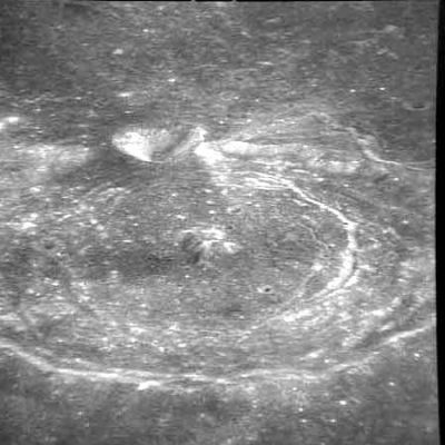
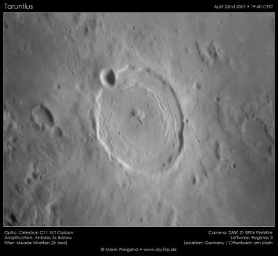
Left: Apollo 10 AS10-31-4566, Right: Mario Weigand
Table of Contents
[#Rimae Taruntius Rimae Taruntius]
[#Rimae Taruntius-Images Images]
[#Rimae Taruntius-Maps Maps]
[#Rimae Taruntius-Description Description]
[#Rimae Taruntius-Description: Wikipedia Description: Wikipedia]
[#Rimae Taruntius-Additional Information Additional Information]
[#Rimae Taruntius-Nomenclature Nomenclature]
[#Rimae Taruntius-LPOD Articles LPOD Articles]
[#Rimae Taruntius-Bibliography Bibliography]
Images
LPOD Photo Gallery Lunar Orbiter Images Apollo Images (see Taruntius)
Maps
([/LAC%20zone LAC zone] 61C2) LAC map Geologic map AIC map LTO map
Description
Description: Wikipedia
Additional Information
I don't know if Rimae Taruntius (aka Fossae Taruntius) is (are) the name(s) for the whole system of curved rilles which run all around the central peak of Taruntius. On Lunar Topographic Orthophotomap 61-C2 the disallowed name Fossae Taruntius is printed at the northern part of the floor of Taruntius, almost invisible and rather small. - DannyCaes DannyCaes Oct 23, 2015
Nomenclature
Within crater. ([/Taruntius Taruntius])
  Called Fossae Taruntius on Lunar Topographic Orthophotomap 61-C2.
LPOD Articles
Bibliography
This page has been edited 1 times. The last modification was made by - tychocrater tychocrater on Jun 13, 2009 3:24 pm - afx3u2