Rimae Opelt
Contents
Rimae Opelt
|
Lat: 13.0°S, Long: 18.0°W, Length: 70 km, Depth: km, Rükl: 42 |
Table of Contents
[#Rimae Opelt Rimae Opelt]
[#Rimae Opelt-Images Images]
[#Rimae Opelt-Maps Maps]
[#Rimae Opelt-Description Description]
[#Rimae Opelt-Description: Wikipedia Description: Wikipedia]
[#Rimae Opelt-Additional Information Additional Information]
[#Rimae Opelt-Nomenclature Nomenclature]
[#Rimae Opelt-LPOD Articles LPOD Articles]
[#Rimae Opelt-Bibliography Bibliography]

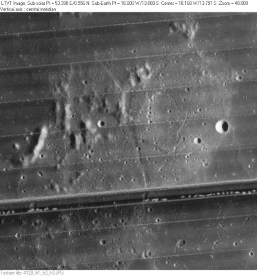
LO-IV-120H A part of Rimae Opelt crosses this unnamed set of hills between Bonpland and Opelt. The 5-km diameter circular crater on the right is Opelt K. The dark band across the image is a defect in the Lunar Orbiter film.
Images
LPOD Photo Gallery Lunar Orbiter Images Apollo Images
Maps
(LAC zone 76C4) LAC map Geologic map LM map
Description
Description: Wikipedia
Additional Information
Nomenclature
Named from nearby crater. (Opelt)
LPOD Articles
Bibliography
This page has been edited 1 times. The last modification was made by - tychocrater tychocrater on Jun 13, 2009 3:24 pm - afx3u2