Polybius
Contents
Polybius
|
Lat: 22.4°S, Long: 25.6°E, Diam: 41 km, Depth: 2.05 km, [/R%C3%BCkl%2057 Rükl: 57] |
Table of Contents

LOIV 084 H1
Images
LPOD Photo Gallery Lunar Orbiter Images Apollo Images
- Although there's nothing in the LPI's search list for orbital Apollo photographs of Polybius, this crater WAS captured on several frames made by the southward looking mapping/metric Fairchild camera of Apollo 16, such as frame AS16-M-0693, which shows Polybius very near the central part of the depicted curved horizon, with the high-albedo bowl shaped crater Polybius A "below" (east of) Polybius itself. Note also the bright ray which runs through Polybius A.
- Research: Danny Caes
Maps
([/LAC%20zone LAC zone] 96B3) LAC map Geologic map
Description
Description: Elger
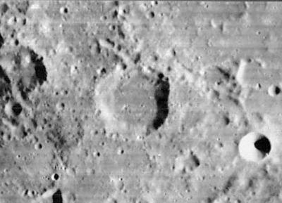
([/IAU%20Directions IAU Directions]) POLYBIUS.--A ring-plain, about 17 miles in diameter, in the hilly region S.W. of [/Fracastorius Fracastorius]. The border is unbroken, except on the N., where it is interrupted by a group of depressions. There is a long valley on the S.E., at the bottom of which Schmidt shows a crater-chain.
Description: Wikipedia
Additional Information
Depth data from [/Kurt%20Fisher%20crater%20depths Kurt Fisher database]
- Arthur, 1974: 2.05 km
- Westfall, 2000: 2.05 km
- Viscardy, 1985: 2.05 km
- Satellite craters Polybius A, B and K are on the [/ALPO%20list%20of%20bright%20ray%20craters ALPO list of bright ray craters].
- Satellite craters Polybius A and B are on the [/ALPO%20list%20of%20banded%20craters ALPO list of banded craters]
Nomenclature
- Polybius (ca. 203–120 BC) was a Greek historian of the Mediterranean world famous for his book called The Histories or The Rise of the Roman Empire, covering in detail the period of 220–146 BC. He is also renowned for his ideas of political balance in the government, which was later used in the drafting of the United States Constitution.
- Polybius Beta (a pronounced section of Rupes Recta, south of Polybius) (see Chart 85 in the Times Atlas of the Moon).
Larrieu's Dam
- A curious formation at Polybius K, near the Rupes Altai, is unofficially called Larrieu's Dam. It was discovered in 1955 by A.C.Larrieu at Marseilles, France (see Bibliography below).- DannyCaes DannyCaes Aug 3, 2015
  - Polybius Beta, a peak in the Rupes Altai, could be a good candidate to be called Gora Belukha (Mount Belukha). On Earth, Gora Belukha is the highest peak in the Altai mountains.- DannyCaes DannyCaes Apr 15, 2008
LPOD Articles
Bibliography
Larrieu's Dam; the 'rediscovery' of a seldom explored topographical lunar feature in the foothills of the Rupes Altai, by Nigel Longshaw.
P.S.:
I did not knew about the appearance of my name (Danny Caes)(sans 's') in that article's last page! (it's because of my experimental Geocities website THE UNKNOWN MOON, which had the very first version of my ABC of Unofficial Lunar Nomenclature in it!). Thanks Nigel Longshaw! - DannyCaes DannyCaes Aug 3, 2015
This page has been edited 1 times. The last modification was made by - tychocrater tychocrater on Jun 13, 2009 3:24 pm - afx3u2