Petavius
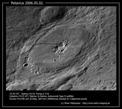
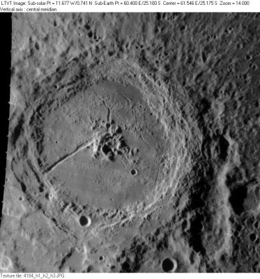
Petavius, with Rimae Petavius on its floor
|
Lat: 25.1°S, Long: 60.4°E, Diam: 188 km, Depth: 3.33 km, [/R%C3%BCkl%2059 Rükl 59], [/Stratigraphy Lower Imbrian] |


Left: Oliver Pettenpaul In this Earth-based photo, north is to the upper right. The 57-km crater shadowed crater above Petavius' (just outside its northwest rim and not visible in the LO view) is [/Wrottesley Wrottesley].
Right: LOIV-184-H2 North-up aerial view (with east to the right). To Petavius' east is an elongated bowling-pin shaped depression known as [/Vallis%20Palitzsch Vallis Palitzsch]. Its lower part is regarded also as a separately-named 41-km crater ([/Palitzsch Palitzsch]). To the lower left of [/Palitzsch Palitzsch] is partically visible 83-km [/Hase Hase], with 14-km [/Hase Hase] A on its floor. 11-km Petavius C (mentioned below under Additional Information) is the circular crater on Petavius' south rim (at top in the inverted Earth-based view). On Petavius' floor are the famous [/Rimae%20Petavius Rimae Petavius], consisting primarily of the branches emanating to the north and southwest (Elger's "great cleft") from the central peaks.
Table of Contents
Images
LPOD Photo Gallery Lunar Orbiter Images Apollo Images
- Close-ups of Petavius, made by [/Lunar%20Orbiter Lunar Orbiter 5], are seen here (Frames 5033 to 5036). Research: Danny Caes
- Image from [/Chang%27e-1 Chang'e-1].
Maps
([/LAC%20zone LAC zone] 98C1) LAC map Geologic map
Description
Description: Elger
([/IAU%20Directions IAU Directions]) PETAVIUS.--The third member of the great meridional chain: a noble walled-plain, with a complex rampart, extending nearly 100 miles from N. to S., which encloses a very rugged convex floor, traversed by many shallow valleys, and includes a massive central mountain and one of the most remarkable clefts on the visible surface. To observe these features to the best advantage, the formation should be viewed when its E. wall is on the evening terminator. At this phase a considerable portion of the interior on the N. is obscured by the shadow of the rampart, but the principal features on the S. half of the floor, and on the broad gently- shelving slope of the E. wall, are seen better than under any other conditions. The border is loftiest on the W., where the ring-plain [/Wrottesley Wrottesley] abuts on it. It rises at this point to nearly 11,000 feet, while on the opposite side it nowhere greatly exceeds 6,000 feet above the interior. The terraces, however, on the E. are much more numerous, and, with the associated valleys, render this section of the wall one of the most striking objects of its class. The N. border is conspicuously broken by the many valleys from the region S. of [/Vendelinus Vendelinus], which run up to and traverse it. On the S., also, it is intersected by gaps, and in one place interrupted by a large crater. There is a remarkable bifurcation of the border S. of [/Wrottesley Wrottesley]. A lower section separates from the main rampart and, extending to a considerable distance S.W. of it, encloses a wide and comparatively level area which is crossed by two short clefts. The central mountains of Petavius, rising at one peak to a height of nearly 6,000 feet above the floor, form a noble group, exceeding in height those in [/Gassendi Gassendi] by more than 2,000 feet. The convexity of the interior is such that the centre of it is about 800 feet higher than the margin, under the walls; a protuberance which would, nevertheless, be scarcely remarked in situ, as it represents no steeper gradient than about 1 in 300 on any portion of its superficies. The great cleft, extending from the central mountains to the S.W. wall, and perhaps beyond, was discovered by Schroter on September 16, 1788, and can be seen in a 2 inch achromatic. In larger instruments it is found to be in places bordered by raised banks.
Description: Wikipedia
Additional Information
- Data from [/Kurt%20Fisher%20crater%20depths Kurt Fisher crater depths]
- Westfall, 2000: 3.33 km
- Viscardy, 1985: 3.3 km
- Cherrington, 1969: 4.2 km
- Central peak height
- [/Sekiguchi%2C%201972 Sekiguchi, 1972]:
- Alpha: 5 km measured on west
- Adjacent to and SW of Alpha: 5 km measured on west
- SSW of Alpha: 1 km
- WSW of Alpha: 1 km
- S of Alpha: 0.8 km
- Two peaks to the east of Alpha: 1.0 (southernmost), 1.2 (northernmost) measured on the east- fatastronomer fatastronomer
- [/Sekiguchi%2C%201972 Sekiguchi, 1972]:
- Exterior impact melt deposits most extensive to S, max of ~60 km beyond rim. Most extensive ejecta, rays and secondary craters to the SSE, with max wall slumping on S side of crater ([/Hawke%20and%20Head%2C%201977 Hawke and Head, 1977]).
- Satellite craters Petavius B and C are on the [/ALPO%20list%20of%20bright%20ray%20craters ALPO list of bright ray craters].
The super boulder in Petavius B
- There's a super-boulder on the southeastern inner slopes of Petavius B. It is already detectable on the LROC's WAC Mosaic (ACT-REACT Quick Map). The pinpoint coordinates of this extremely large chunk of rock (diam. half-a-kilometer!) are: LAT -20.1750, LON 57.4950. - DannyCaes DannyCaes Aug 17, 2014
- ACT-REACT Quick Map close up link: http://bit.ly/1p3a8YQ
- This super boulder is perhaps also detectable on the Hi-Res scan of Apollo 12's orbital color Hasselblad photograph of Petavius B:AS12-50-7458. - DannyCaes DannyCaes Aug 17, 2014
- It was also captured near the upper margin of Lunar Orbiter 4's frame LOIV-053-h1. - DannyCaes DannyCaes Aug 17, 2014
The railroad at the southwestern part of the rim of Petavius
- I can't imagine it's a totally new discovery, this railroad-like feature on the southwestern part of the rim of Petavius. What is it? It seems to start just east of Wrottesley (the crater which is touching the west-northwestern part of the rim of Petavius) and it runs all the way to the southeast through the bowl-shaped crater Petavius C, and... much further across the unimpressive craters Hase and Hase D, until it meets Rimae Hase (or... are the railroad and Rimae Hase perhaps one and the same feature?). - DannyCaes DannyCaes Jan 4, 2016
Nomenclature
- Named for Denis Pétau, also known as Dionysius Petavius (August 21, 1583 – December 11, 1652), a French chronologist and astronomer. He was one of the most brilliant scholars in a learned age. The complete list of his works fills twenty-five columns in Sommervogel: he treats of chronology, history, philosophy, polemics, patristics, and the history of dogma.
- According to [/Whitaker Whitaker] (p. 214) this name has continued unchanged since its original use for this feature on [/Riccioli Riccioli]'s map; although Riccioli wrote it Petavius Soc. I, where "Soc. I" stands for "Society of Jesus" (see [/Nomenclature-Jesuits Jesuit Astronomers]).
- Petavius B, a ray-crater north-northwest of Petavius itself, was called Orus by Hugh Percy Wilkins and Antonio Paluzie-Borrell, but the [/IAU IAU] did not accept that name. Joan J. Orus was a Spanish astronomer.
LPOD Articles
Trenchant Observations on a Trench. On the Limb Again. LPOD (Repeat of 3/7/2006 A Bend in the Middle Moderate Sun over a Magnificent Crater On the Limb Again A New Kind of DHC Petavius Naked
Petavius: Rilles & Volcanic Spots Four in a Row Petavian View
 Outside
 Revisiting Familiar Ground
 Pastel Evidence
Petavius B: Oblique Fireworks
Lunar 100
[/Lunar%20100 L16]: Crater with domed & fractured floor.
Bibliography
- Wood, C.A. Dec. 2004. Floor-Fractured Craters. S&T 12/2004:71
- Wood, C.A. Mar. 2004. Sunrise at Petavius and Vendelinus. S&T March 2004 v107 p121
- Wood, C.A. Mar. 2002. Furnerius, Petavius, and Humboldt. S&T March 2002 v103 p107
- [/A%20Portfolio%20of%20Lunar%20Drawings A Portfolio of Lunar Drawings] (Harold Hill), see: the first drawing in that book, on a number-less page.
- Petavius B ("Orus"): [/Wilkins%20and%20Moore Wilkins and Moore].
This page has been edited 1 times. The last modification was made by - tychocrater tychocrater on Jun 13, 2009 3:24 pm - afx3u2