Difference between revisions of "Olcott"
(Created page with "<div id="content_view" class="wiki" style="display: block"> =Olcott= {| class="wiki_table" | Lat: 20.6°N, Long: 117.8°E, Diam: 81 km, Depth: km, Rükl: ''(farside)'', [/...") |
|||
| Line 3: | Line 3: | ||
{| class="wiki_table" | {| class="wiki_table" | ||
| | | | ||
| − | Lat: 20.6°N, Long: 117.8°E, Diam: 81 km, Depth: km, Rükl: ''(farside)'', [ | + | Lat: 20.6°N, Long: 117.8°E, Diam: 81 km, Depth: km, Rükl: ''(farside)'', [[Stratigraphy|Eratosthenian]]<br /> |
|} | |} | ||
<div id="toc"> | <div id="toc"> | ||
| Line 11: | Line 11: | ||
[http://www.lpod.org/coppermine/thumbnails.php?album=search&type=full&search=Olcott LPOD Photo Gallery] [http://www.lpi.usra.edu/resources/lunar_orbiter/bin/srch_nam.shtml?Olcott%7C0 Lunar Orbiter Images] [http://www.lpi.usra.edu/resources/apollo/search/feature/?feature=Olcott Apollo Images]<br /> <br /> | [http://www.lpod.org/coppermine/thumbnails.php?album=search&type=full&search=Olcott LPOD Photo Gallery] [http://www.lpi.usra.edu/resources/lunar_orbiter/bin/srch_nam.shtml?Olcott%7C0 Lunar Orbiter Images] [http://www.lpi.usra.edu/resources/apollo/search/feature/?feature=Olcott Apollo Images]<br /> <br /> | ||
==Maps== | ==Maps== | ||
| − | ''([ | + | ''([[LAC%20zone|LAC zone]] 47D2)'' [http://planetarynames.wr.usgs.gov/images/Lunar/lac_47.pdf USGS Digital Atlas PDF]<br /> <br /> |
==Description== | ==Description== | ||
<br /> | <br /> | ||
| Line 17: | Line 17: | ||
[http://en.wikipedia.org/wiki/Olcott_(crater) Olcott]<br /> <br /> | [http://en.wikipedia.org/wiki/Olcott_(crater) Olcott]<br /> <br /> | ||
==Additional Information== | ==Additional Information== | ||
| − | * [ | + | * [[Central%20peak%20composition|Central peak composition]]: A, GNTA1 & GNTA2 ([[Tompkins%20%26%20Pieters%2C%201999|Tompkins & Pieters, 1999]]) |
| − | * TSI = 25, CPI = 25, FI = 20; MI =70 [ | + | * TSI = 25, CPI = 25, FI = 20; MI =70 [[Smith%20and%20Sanchez%2C%201973|Smith and Hartnell, 1973]] |
* An oblique impact raycrater is located east-southeast of '''Olcott''' (see the photographic albedo-chart for LAC 47 in the ''Clementine Atlas''). The pinpoint coordinates of this raycrater are: Longitude 121.3. Latitude 18.7. It's most interesting to explore the inner and outer slopes (albedo differences) of this raycrater via the LRO's [http://target.lroc.asu.edu/da/qmap.html ACT-REACT Quick Map]. <span class="membersnap">- [http://www.wikispaces.com/user/view/DannyCaes [[Image:DannyCaes-lg.jpg|16px|DannyCaes]]] [http://www.wikispaces.com/user/view/DannyCaes DannyCaes] <small>Jun 5, 2011</small></span> | * An oblique impact raycrater is located east-southeast of '''Olcott''' (see the photographic albedo-chart for LAC 47 in the ''Clementine Atlas''). The pinpoint coordinates of this raycrater are: Longitude 121.3. Latitude 18.7. It's most interesting to explore the inner and outer slopes (albedo differences) of this raycrater via the LRO's [http://target.lroc.asu.edu/da/qmap.html ACT-REACT Quick Map]. <span class="membersnap">- [http://www.wikispaces.com/user/view/DannyCaes [[Image:DannyCaes-lg.jpg|16px|DannyCaes]]] [http://www.wikispaces.com/user/view/DannyCaes DannyCaes] <small>Jun 5, 2011</small></span> | ||
==Nomenclature== | ==Nomenclature== | ||
Revision as of 16:07, 15 April 2018
Contents
Olcott
|
Lat: 20.6°N, Long: 117.8°E, Diam: 81 km, Depth: km, Rükl: (farside), Eratosthenian |
Table of Contents
[#Olcott Olcott]
[#Olcott-Images Images]
[#Olcott-Maps Maps]
[#Olcott-Description Description]
[#Olcott-Description: Wikipedia Description: Wikipedia]
[#Olcott-Additional Information Additional Information]
[#Olcott-Nomenclature Nomenclature]
[#Olcott-LPOD Articles LPOD Articles]
[#Olcott-Bibliography Bibliography]


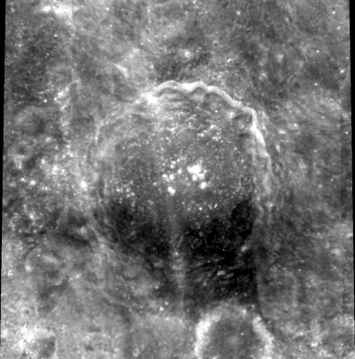
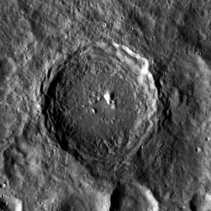
left: Clementine . right: LROC . Note dark terrain on south-east sector, inside and outside Olcott .
Images
LPOD Photo Gallery Lunar Orbiter Images Apollo Images
Maps
(LAC zone 47D2) USGS Digital Atlas PDF
Description
Description: Wikipedia
Additional Information
- Central peak composition: A, GNTA1 & GNTA2 (Tompkins & Pieters, 1999)
- TSI = 25, CPI = 25, FI = 20; MI =70 Smith and Hartnell, 1973
- An oblique impact raycrater is located east-southeast of Olcott (see the photographic albedo-chart for LAC 47 in the Clementine Atlas). The pinpoint coordinates of this raycrater are: Longitude 121.3. Latitude 18.7. It's most interesting to explore the inner and outer slopes (albedo differences) of this raycrater via the LRO's ACT-REACT Quick Map. - DannyCaes DannyCaes Jun 5, 2011
Nomenclature
William Tyler Olcott (January 11, 1873 – July 6, 1936) was an American lawyer and amateur astronomer. In 1909, after attending a lecture by Edward Pickering, he developed an interest in observing variable stars. In 1911, he and professor Pickering founded the American Association of Variable Star Observers (AAVSO). Olcott also published several books to popularize the field of amateur astronomy.
Catena Olcott is an unofficial name from D.Caes for the chain of depressions east-southeast of Olcott E, north-northwest of Kostinskiy D.
LPOD Articles
Bibliography
W.T.Olcott is frequently mentioned in Burnham's Celestial Handbook. If all goes well, a list of pages (of Burnham's) in which W.T.Olcott is mentioned will appear here. Burnham himself never created an alphabetic index of the hundreds of names scattered throughout the three volumes of his handbook... - DannyCaes DannyCaes May 8, 2015
This page has been edited 1 times. The last modification was made by - tychocrater tychocrater on Jun 13, 2009 3:24 pm - afx3u2