Montes Taurus
Contents
Montes Taurus
|
Lat: 28.4°N, Long: 41.1°E, Diam: 172 km, Height: 3 km, [/R%C3%BCkl%2025 Rükl: 25] |
Table of Contents

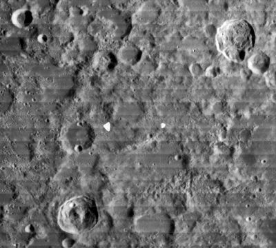
LOIV-074-H1 This view extends from 39-km diameter [/R%C3%B6mer Römer] (in the lower right) to 41-km [/Newcomb Newcomb] in the upper right. Montes Taurus refers to most of the hilly region between these two craters. The 20-km crater in the upper left is [/G.%20Bond G. Bond]. It lies outside the Montes Taurus area, whose boundary (according to the IAU position and diameter) is apparently closer to [/Kirchhoff Kirchhoff], the more deeply shadowed of the 24-km craters at about 4 o'clock from [/G.%20Bond G. Bond].
Images
LPOD Photo Gallery Lunar Orbiter Images Apollo Images
Maps
([/LAC%20zone LAC zone] 43B1) LAC map Geologic map
Description
Description: Elger
([/IAU%20Directions IAU Directions]) THE TAURUS MOUNTAINS.--extend from the east side of the [/Mare%20Serenitatis Mare Serenitatis], near [/Le%20Monnier Le Monnier] and [/Littrow Littrow], in a north-easterly direction towards [/Geminus Geminus] and [/Berzelius Berselius], bordering the east side of the [/Lacus%20Somniorum Lacus Somniorum]. They are a far less remarkable system than any of the preceding, and consist rather of a wild irregular mountain region than a range. In the neighbourhood of [/Berzelius Berselius] are some peaks which, according to Neison, cannot be less than 10,000 feet in height.
- Note: the range described by Elger spans a length of more than 700 km -- far more expansive than the current IAU definition.
Description: Wikipedia
Additional Information
Depth data from [/Kurt%20Fisher%20crater%20depths Kurt Fisher database]
- Viscardy, 1985: 3 km
- Cherrington, 1969: 2.98 km
Nomenclature
- Named after the terrestrial Taurus Mts in southern Turkey.
- According to [/Whitaker Whitaker] (p. 208), the name Mons Taurus was used by [/Hevelius Hevelius], but he used the name for a bright ray running east from [/Tycho Tycho]. It is not clear from Whitaker's book who first associated the name with the modern feature.
- In the original [/IAU%20Nomenclature IAU Nomenclature] of [/Blagg%20and%20M%C3%BCller Blagg and Müller] (1935), this range was known as the Taurus Mts.
- The name was Latinized to Montes Taurus in [/IAU%20Transactions%20XIIB IAU Transactions XIIB] (1964).
LPOD Articles
Bibliography
For those who might be interested in geophysical luminous phenomena which appear in the terrestrial Taurus mountains: Lights in the Taurus Mountains.
This page has been edited 1 times. The last modification was made by - tychocrater tychocrater on Jun 13, 2009 3:24 pm - afx3u2