Difference between revisions of "Mercator"
| Line 6: | Line 6: | ||
|} | |} | ||
<div id="toc"> | <div id="toc"> | ||
| − | + | [http://www.lpod.org/coppermine/displayimage.php?pid=1687&fullsize=1 [[Image:normal_Mercator-LO-IV-131-h3.jpg|external image normal_Mercator-LO-IV-131-h3.jpg]]]<br /> ''[http://lpod.org/coppermine/displayimage.php?pos=-1687 LO-IV-131-h3]''<br /> <br /> | |
| − | |||
==Images== | ==Images== | ||
[http://www.lpod.org/coppermine/thumbnails.php?album=search&type=full&search=Mercator LPOD Photo Gallery] [http://www.lpi.usra.edu/resources/lunar_orbiter/bin/srch_nam.shtml?Mercator%7C0 Lunar Orbiter Images]<br /> <br /> | [http://www.lpod.org/coppermine/thumbnails.php?album=search&type=full&search=Mercator LPOD Photo Gallery] [http://www.lpi.usra.edu/resources/lunar_orbiter/bin/srch_nam.shtml?Mercator%7C0 Lunar Orbiter Images]<br /> <br /> | ||
| Line 41: | Line 40: | ||
<br /> <br /> | <br /> <br /> | ||
---- | ---- | ||
| − | + | </div> | |
Revision as of 17:38, 15 April 2018
Contents
Mercator
|
Lat: 29.3°S, Long: 26.1°W, Diam: 46 km, Depth: 1.1 km, Rükl 53, Nectarian |

Images
LPOD Photo Gallery Lunar Orbiter Images
Maps
(LAC zone 94D4) LAC map Geologic map
Description
Description: Elger
(IAU Directions) MERCATOR.--A more irregular ring-plain of about the same area, adjoining Campanus on the S.E. Its rampart is somewhat lower, and is partially broken on the N. by two semi-rings, and on the S. by a gap. The W. wall extends on the S. far beyond the limits of the formation, and terminates in a brilliant mountain mass 6,000 feet in height. There is a bright crater on the crest of both the W. and E. border. On the plain W. of Mercator is a remarkable little crater standing on a light area, and, just under the wall, a dusky pit connected with it by a rill-like marking. These objects are of a very doubtful nature, and should be carefully observed. The floor of Mercator is much lighter than that of Campanus, and appears to be devoid of detail.
Description: Wikipedia
Additional Information
- Depth data from Kurt Fisher database
- Pike, 1976: 1.1 km
- Arthur, 1974: 2.3 km
- Westfall, 2000: 1.1 km
- Viscardy, 1985: 1.76 km
- Cherrington, 1969: 1.31 km
- Satellite crater Mercator A is on the ALPO list of bright ray craters.
Nomenclature
- Named for Gerardus Mercator (Gerard de Cremere) (March 5, 1512 – December 2, 1594), a Flemish cartographer, geographer and mathematician . He is remembered for the Mercator chart named after him. Mercator devised a technique to produce globes— celestial as well as terrestrial— by techniques of relative mass production.
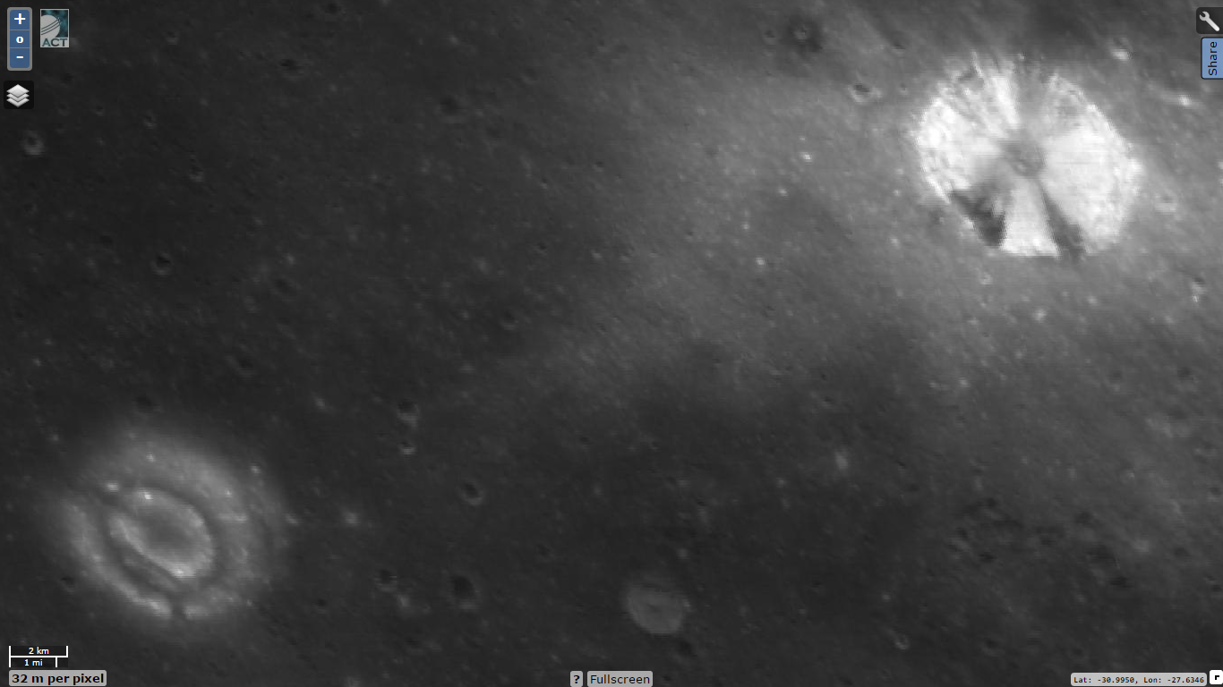
- Danny Caes calls satellite crater Mercator A "The X-crater" because of the curious X-shaped system of dark bands on its inner slopes. See: Clementine's close-up, and also the LRO's low-res view of it at LON: -27.8, LAT: -30.7 (32 M/PIX), on the ACT-REACT Quick Map. [[user:DannyCaes|1207407250]
.png)
Marth (6,5 km) at SW and Mercator A (8,2 km) at NE from LRO (local noon).
Lettered Craters

Excerpt from the USGS Digital Atlas of the Moon.
LPOD Articles
Bibliography
- Hill, Harold. A Portfolio of Lunar Drawings, pages 112, 113.