Difference between revisions of "Gruemberger"
(Created page with "<div id="content_view" class="wiki" style="display: block"> =Gruemberger= {| class="wiki_table" | Lat: 66.9°S, Long: 10.0°W, Diam: 93 km, Depth: 5.14 km, [/R%C3%BCkl%207...") |
|||
| Line 3: | Line 3: | ||
{| class="wiki_table" | {| class="wiki_table" | ||
| | | | ||
| − | Lat: 66.9°S, Long: 10.0°W, Diam: 93 km, Depth: 5.14 km, [ | + | Lat: 66.9°S, Long: 10.0°W, Diam: 93 km, Depth: 5.14 km, [[R%C3%BCkl%2073|Rükl: 73]]<br /> |
|} | |} | ||
<div id="toc"> | <div id="toc"> | ||
=Table of Contents= | =Table of Contents= | ||
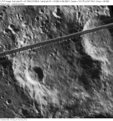
| − | <div style="margin-left: 1em">[#Gruemberger Gruemberger]</div><div style="margin-left: 2em">[#Gruemberger-Images Images]</div><div style="margin-left: 2em">[#Gruemberger-Maps Maps]</div><div style="margin-left: 2em">[#Gruemberger-Description Description]</div><div style="margin-left: 2em">[#Gruemberger-Description: Elger Description: Elger]</div><div style="margin-left: 2em">[#Gruemberger-Description: Wikipedia Description: Wikipedia]</div><div style="margin-left: 2em">[#Gruemberger-Additional Information Additional Information]</div><div style="margin-left: 2em">[#Gruemberger-Nomenclature Nomenclature]</div><div style="margin-left: 2em">[#Gruemberger-LPOD Articles LPOD Articles]</div><div style="margin-left: 2em">[#Gruemberger-Bibliography Bibliography]</div></div>[http://www.lpod.org/coppermine/albums/userpics/Gruemberger_LO-IV-130H_LTVT.JPG [[Image:normal_Gruemberger_LO-IV-130H_LTVT.JPG|external image normal_Gruemberger_LO-IV-130H_LTVT.JPG]]]<br /> ''[http://lpod.org/coppermine/displayimage.php?pos=-2675 LO-IV-130H]'' The 20-km crater on the southwest floor is '''Gruemberger A'''. [ | + | <div style="margin-left: 1em">[#Gruemberger Gruemberger]</div><div style="margin-left: 2em">[#Gruemberger-Images Images]</div><div style="margin-left: 2em">[#Gruemberger-Maps Maps]</div><div style="margin-left: 2em">[#Gruemberger-Description Description]</div><div style="margin-left: 2em">[#Gruemberger-Description: Elger Description: Elger]</div><div style="margin-left: 2em">[#Gruemberger-Description: Wikipedia Description: Wikipedia]</div><div style="margin-left: 2em">[#Gruemberger-Additional Information Additional Information]</div><div style="margin-left: 2em">[#Gruemberger-Nomenclature Nomenclature]</div><div style="margin-left: 2em">[#Gruemberger-LPOD Articles LPOD Articles]</div><div style="margin-left: 2em">[#Gruemberger-Bibliography Bibliography]</div></div>[http://www.lpod.org/coppermine/albums/userpics/Gruemberger_LO-IV-130H_LTVT.JPG [[Image:normal_Gruemberger_LO-IV-130H_LTVT.JPG|external image normal_Gruemberger_LO-IV-130H_LTVT.JPG]]]<br /> ''[http://lpod.org/coppermine/displayimage.php?pos=-2675 LO-IV-130H]'' The 20-km crater on the southwest floor is '''Gruemberger A'''. [[Cysatus|Cysatus]] is partially visible in the upper right. The dark band across the image is a flaw in the development of the [[Lunar%20Orbiter|Lunar Orbiter]] film.<br /> <br /> |
==Images== | ==Images== | ||
[http://www.lpod.org/coppermine/thumbnails.php?album=search&type=full&search=Gruemberger LPOD Photo Gallery] [http://www.lpi.usra.edu/resources/lunar_orbiter/bin/srch_nam.shtml?Gruemberger%7C0 Lunar Orbiter Images] [http://www.lpi.usra.edu/resources/apollo/search/feature/?feature=Gruemberger Apollo Images]<br /> <br /> | [http://www.lpod.org/coppermine/thumbnails.php?album=search&type=full&search=Gruemberger LPOD Photo Gallery] [http://www.lpi.usra.edu/resources/lunar_orbiter/bin/srch_nam.shtml?Gruemberger%7C0 Lunar Orbiter Images] [http://www.lpi.usra.edu/resources/apollo/search/feature/?feature=Gruemberger Apollo Images]<br /> <br /> | ||
==Maps== | ==Maps== | ||
| − | ''([ | + | ''([[LAC%20zone|LAC zone]] 137B1)'' [http://planetarynames.wr.usgs.gov/images/Lunar/lac_137.pdf USGS Digital Atlas PDF]<br /> <br /> |
==Description== | ==Description== | ||
<br /> | <br /> | ||
==Description: Elger== | ==Description: Elger== | ||
| − | ''([ | + | ''([[IAU%20Directions|IAU Directions]])'' GRUEMBERGER.--A much larger and more irregular ring-plain, nearly 40 miles from wall to wall, on the W. side of [[Cysatus|Cysatus]]. Its E. border rises nearly 14,000 feet above the interior, which includes an abnormally deep crater, the bottom of which is 20,000 feet below the crest of the E. wall, and several small depressions and ridges. The inner W. slope is finely terraced.<br /> <br /> |
==Description: Wikipedia== | ==Description: Wikipedia== | ||
[http://en.wikipedia.org/wiki/Gruemberger_(crater) Gruemberger]<br /> <br /> | [http://en.wikipedia.org/wiki/Gruemberger_(crater) Gruemberger]<br /> <br /> | ||
==Additional Information== | ==Additional Information== | ||
| − | Depth data from [ | + | Depth data from [[Kurt%20Fisher%20crater%20depths|Kurt Fisher database]]<br /> |
* Westfall, 2000: 5.14 km | * Westfall, 2000: 5.14 km | ||
* Viscardy, 1985: 4.3 km | * Viscardy, 1985: 4.3 km | ||
| Line 26: | Line 26: | ||
==Nomenclature== | ==Nomenclature== | ||
| − | * [http://en.wikipedia.org/wiki/Christoph_Grienberger Christoph Grienberger] (1561-1636), an Austrian [ | + | * [http://en.wikipedia.org/wiki/Christoph_Grienberger Christoph Grienberger] (1561-1636), an Austrian [[nomenclature-Jesuits|Jesuit astronomer]] whose last name was spelled in many variants. Grienberger corresponded with both [[Galileo%20Galilei|Galileo]] and [[Blancanus|Biancani]] regarding the possible existence of mountains on the Moon (which the latter rejected). |
| − | * According to ''[ | + | * According to ''[[Whitaker|Whitaker]]'' (p. 219), this feature was labeled '''Gruemberger Soc. I''' on [[Riccioli|Riccioli]]'s map, with the "Soc. I" being deleted to form the modern name. <span class="membersnap">- [http://www.wikispaces.com/user/view/JimMosher [[Image:JimMosher-lg.jpg|16px|JimMosher]]] [http://www.wikispaces.com/user/view/JimMosher JimMosher]</span> |
<br /> | <br /> | ||
==LPOD Articles== | ==LPOD Articles== | ||
Revision as of 15:50, 15 April 2018
Contents
Gruemberger
|
Lat: 66.9°S, Long: 10.0°W, Diam: 93 km, Depth: 5.14 km, Rükl: 73 |
Table of Contents
[#Gruemberger Gruemberger]
[#Gruemberger-Images Images]
[#Gruemberger-Maps Maps]
[#Gruemberger-Description Description]
[#Gruemberger-Description: Elger Description: Elger]
[#Gruemberger-Description: Wikipedia Description: Wikipedia]
[#Gruemberger-Additional Information Additional Information]
[#Gruemberger-Nomenclature Nomenclature]
[#Gruemberger-LPOD Articles LPOD Articles]
[#Gruemberger-Bibliography Bibliography]

LO-IV-130H The 20-km crater on the southwest floor is Gruemberger A. Cysatus is partially visible in the upper right. The dark band across the image is a flaw in the development of the Lunar Orbiter film.
Images
LPOD Photo Gallery Lunar Orbiter Images Apollo Images
Maps
(LAC zone 137B1) USGS Digital Atlas PDF
Description
Description: Elger
(IAU Directions) GRUEMBERGER.--A much larger and more irregular ring-plain, nearly 40 miles from wall to wall, on the W. side of Cysatus. Its E. border rises nearly 14,000 feet above the interior, which includes an abnormally deep crater, the bottom of which is 20,000 feet below the crest of the E. wall, and several small depressions and ridges. The inner W. slope is finely terraced.
Description: Wikipedia
Additional Information
Depth data from Kurt Fisher database
- Westfall, 2000: 5.14 km
- Viscardy, 1985: 4.3 km
- Cherrington, 1969: 4.11 km
Nomenclature
- Christoph Grienberger (1561-1636), an Austrian Jesuit astronomer whose last name was spelled in many variants. Grienberger corresponded with both Galileo and Biancani regarding the possible existence of mountains on the Moon (which the latter rejected).
- According to Whitaker (p. 219), this feature was labeled Gruemberger Soc. I on Riccioli's map, with the "Soc. I" being deleted to form the modern name. - JimMosher JimMosher
LPOD Articles
Bibliography
This page has been edited 1 times. The last modification was made by - tychocrater tychocrater on Jun 13, 2009 3:24 pm - afx3