Difference between revisions of "Comstock"
(Created page with "<div id="content_view" class="wiki" style="display: block"> =Comstock= {| class="wiki_table" | Lat: 21.8°N, Long: 121.5°W, Diam: 72 km, Depth: km, Rükl: ''(farside)'',...") |
|||
| (4 intermediate revisions by the same user not shown) | |||
| Line 3: | Line 3: | ||
{| class="wiki_table" | {| class="wiki_table" | ||
| | | | ||
| − | Lat: 21.8°N, Long: 121.5°W, Diam: 72 km, Depth: km, Rükl: ''(farside)'', [ | + | Lat: 21.8°N, Long: 121.5°W, Diam: 72 km, Depth: km, Rükl: ''(farside)'', [[Stratigraphy|pre-Nectarian]]<br /> |
|- | |- | ||
| | | | ||
| − | [http://lpod.org/coppermine/displayimage.php?pid=4294&fullsize=1 [[Image: | + | [http://lpod.org/coppermine/displayimage.php?pid=4294&fullsize=1 [[Image:Normal_comstock-large.jpg|external image normal_comstock-large.jpg]]]<br /> |
| | | | ||
| − | [[Image: | + | [[Image:Comstock-color.jpg|comstock-color.jpg]]<br /> |
|} | |} | ||
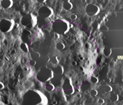
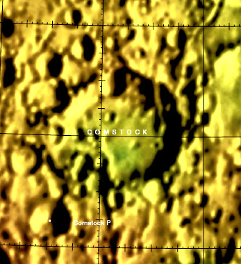
| − | '''Left:''' ''[http://the-moon. | + | '''Left:''' ''[http://the-moon.us/wiki/file/detail/comstock-large2.jpg Annotated]'' [http://www.mapaplanet.org/explorer-bin/explorer.cgi?map=Moon&layers=moon_lo&info=NO&advoption=YES&sizeSelector=imageSize&lines=722&samples=1440&Resolution=91.8575063613232&r=1&g=1&b=1&projection=SIMP&grid=none&stretch=auto&north=20.19&south=24.12&west=234.79&east=242.62¢er_lat=0¢er=238.705&defaultcenter=on Lunar Orbiter] image from [http://www.mapaplanet.org Map-A-Planet]. '''Right:''' [http://planetarynames.wr.usgs.gov/images/Lunar/lac_53.pdf Color-coded topography LAC 53] image from [[USGS%20Digital%20Atlas|USGS Digital Atlas]].<br /> <div id="toc"> |
| − | + | ||
| − | |||
==Images== | ==Images== | ||
[http://www.lpod.org/coppermine/thumbnails.php?album=search&type=full&search=Comstock LPOD Photo Gallery] [http://www.lpi.usra.edu/resources/lunar_orbiter/bin/srch_nam.shtml?Comstock%7C0 Lunar Orbiter Images]<br /> <br /> | [http://www.lpod.org/coppermine/thumbnails.php?album=search&type=full&search=Comstock LPOD Photo Gallery] [http://www.lpi.usra.edu/resources/lunar_orbiter/bin/srch_nam.shtml?Comstock%7C0 Lunar Orbiter Images]<br /> <br /> | ||
==Maps== | ==Maps== | ||
| − | ''([ | + | ''([[LAC%20zone|LAC zone]] 53D2)'' [http://planetarynames.wr.usgs.gov/images/Lunar/lac_53.pdf USGS Digital Atlas PDF]<br /> <br /> |
==Description== | ==Description== | ||
| − | A crater of the [ | + | A crater of the [[Stratigraphy|pre-Nectarian]] period (~ 4.6 to 3.92 bn years), '''Comstock''' shows all the signs of a well-worn, well-bombarded, well-aged crater that has seen more than its fair share of impact history. Not a portion of its once existant rim (let alone its floor) can be seen amongst the turmoil of impact events which have altered respective regions through further impacts, slumping, and ejecta deposits from prominant basin events like [[Hertzsprung|Hertzsprung]] to its south and [[Mare%20Orientale|Orientale]] to its south-east. [[Ohm|Ohm]] crater ([[Stratigraphy|Copernican]] ~ 1.1 bn years to present in age) to its south-east has also overlain traces of ray material onto its hard-defined floor -- better seen in this [http://www.mapaplanet.org/explorer-bin/explorer.cgi?map=Moon&layers=moon_clementine_base_v2&west=105&south=159&east=146&north=121¢er=0¢er_lat=0&defaultcenter=on&grid=none&stretch=auto&resamp_method=nearest_neighbor&projection=SIMP&r=1&g=1&b=1&advoption=YES&info=NO&resolution=2&lines=360&samples=720&scale=15.16167&imageTopX=-5450622.3254203796&imageTopY=2721520.7438468933&box=yes&x=140&y=153 Clementine] image from [http://www.mapaplanet.org Map-A-Planet]. <span class="membersnap">- JohnMoore2</span><br /> <br /> |
==Description: Wikipedia== | ==Description: Wikipedia== | ||
[http://en.wikipedia.org/wiki/Comstock_(crater) Comstock]<br /> <br /> | [http://en.wikipedia.org/wiki/Comstock_(crater) Comstock]<br /> <br /> | ||
| Line 36: | Line 35: | ||
<br /> | <br /> | ||
---- | ---- | ||
| − | + | </div> | |
Latest revision as of 21:08, 16 April 2018
Contents
Comstock
|
Lat: 21.8°N, Long: 121.5°W, Diam: 72 km, Depth: km, Rükl: (farside), pre-Nectarian | |
Images
LPOD Photo Gallery Lunar Orbiter Images
Maps
(LAC zone 53D2) USGS Digital Atlas PDF
Description
A crater of the pre-Nectarian period (~ 4.6 to 3.92 bn years), Comstock shows all the signs of a well-worn, well-bombarded, well-aged crater that has seen more than its fair share of impact history. Not a portion of its once existant rim (let alone its floor) can be seen amongst the turmoil of impact events which have altered respective regions through further impacts, slumping, and ejecta deposits from prominant basin events like Hertzsprung to its south and Orientale to its south-east. Ohm crater (Copernican ~ 1.1 bn years to present in age) to its south-east has also overlain traces of ray material onto its hard-defined floor -- better seen in this Clementine image from Map-A-Planet. - JohnMoore2
Description: Wikipedia
Additional Information
- Orientale secondary craters occur on the crater.
Nomenclature
George Cary; American astronomer (1855-1934).
LPOD Articles
Bibliography
G. C. Comstock in the Sourcebook Project (William R. Corliss)
- In Mysterious Universe, a handbook of astronomical anomalies (1979) :
- Page 479: On the Reversed Curvature of the Shadow on Saturn's Rings (Aldro Jenks, Sidereal Messenger, 1890).

