Difference between revisions of "Birkeland"
| Line 3: | Line 3: | ||
{| class="wiki_table" | {| class="wiki_table" | ||
| | | | ||
| − | Lat: 30.2°S, Long: 173.9°E, Diam: 82 km, Depth: km, Rükl: ''(farside)'', [ | + | Lat: 30.2°S, Long: 173.9°E, Diam: 82 km, Depth: km, Rükl: ''(farside)'', [[Stratigraphy|Eratosthenian]]<br /> |
|- | |- | ||
| | | | ||
| Line 10: | Line 10: | ||
[[Image:birkeland-color.jpg|birkeland-color.jpg]]<br /> | [[Image:birkeland-color.jpg|birkeland-color.jpg]]<br /> | ||
|} | |} | ||
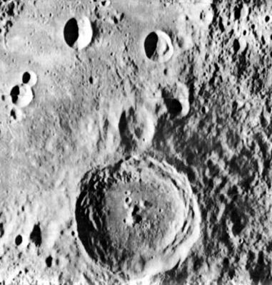
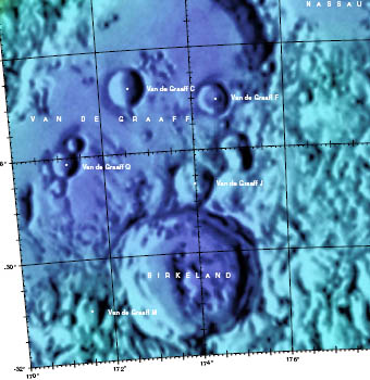
| − | '''Left''' [http://www.lpi.usra.edu/resources/lunarorbiter/frame/?2033 LO2 - Frame No. 2033] from the [http://www.lpi.usra.edu/resources/lunarorbiter/mission/?2 Lunar & Planetary Institute]. '''Right''' [http://planetarynames.wr.usgs.gov/images/Lunar/lac_104.pdf Color-coded LAC 104] from the [ | + | '''Left''' [http://www.lpi.usra.edu/resources/lunarorbiter/frame/?2033 LO2 - Frame No. 2033] from the [http://www.lpi.usra.edu/resources/lunarorbiter/mission/?2 Lunar & Planetary Institute]. '''Right''' [http://planetarynames.wr.usgs.gov/images/Lunar/lac_104.pdf Color-coded LAC 104] from the [[USGS%20Digital%20Atlas|USGS Digital Atlas]] (see Note in 'Images' section below).<br /> <div id="toc"> |
=Table of Contents= | =Table of Contents= | ||
<div style="margin-left: 1em">[#Birkeland Birkeland]</div><div style="margin-left: 2em">[#Birkeland-Images Images]</div><div style="margin-left: 2em">[#Birkeland-Maps Maps]</div><div style="margin-left: 2em">[#Birkeland-Description Description]</div><div style="margin-left: 2em">[#Birkeland-Description: Wikipedia Description: Wikipedia]</div><div style="margin-left: 2em">[#Birkeland-Additional Information Additional Information]</div><div style="margin-left: 2em">[#Birkeland-The very chaotic swirl field east of Birkeland The very chaotic swirl field east of Birkeland]</div><div style="margin-left: 2em">[#Birkeland-Nomenclature Nomenclature]</div><div style="margin-left: 2em">[#Birkeland-LPOD Articles LPOD Articles]</div><div style="margin-left: 2em">[#Birkeland-Bibliography Bibliography]</div></div> | <div style="margin-left: 1em">[#Birkeland Birkeland]</div><div style="margin-left: 2em">[#Birkeland-Images Images]</div><div style="margin-left: 2em">[#Birkeland-Maps Maps]</div><div style="margin-left: 2em">[#Birkeland-Description Description]</div><div style="margin-left: 2em">[#Birkeland-Description: Wikipedia Description: Wikipedia]</div><div style="margin-left: 2em">[#Birkeland-Additional Information Additional Information]</div><div style="margin-left: 2em">[#Birkeland-The very chaotic swirl field east of Birkeland The very chaotic swirl field east of Birkeland]</div><div style="margin-left: 2em">[#Birkeland-Nomenclature Nomenclature]</div><div style="margin-left: 2em">[#Birkeland-LPOD Articles LPOD Articles]</div><div style="margin-left: 2em">[#Birkeland-Bibliography Bibliography]</div></div> | ||
| Line 18: | Line 18: | ||
<br /> | <br /> | ||
==Maps== | ==Maps== | ||
| − | ''([ | + | ''([[LAC%20zone|LAC zone]] 104D4)'' [http://www.lpi.usra.edu/resources/mapcatalog/LM/lm104/ LM map]<br /> <br /> |
==Description== | ==Description== | ||
| − | '''Birkeland''' lies on the north-western region of the [ | + | '''Birkeland''' lies on the north-western region of the [[South%20Pole-Aitken%20Basin|South Pole Aitken Basin]] -- a 2500 kilometre-wide basin of the [[Stratigraphy|pre-Nectarian]] period (~ 4.6 to 3.92 bn years). Aged as [[Stratigraphy|Eratosthenian]] (~ 3.2 to 1.1 bn years), the crater's rim looks relatively fresh along with the subsequent terraces that formed within its interior. Several small craters (the largest about 5 kilometres across) lie on the floor of '''Birkeland''', and its centre has one main peak with another smaller detached one just to its north-east. The physical impact that produced '''Birkeland''' has undoubtedly thrown ejecta deposits all around it, and these are just about seen as radial striations on the floor of the nearby [[Van%20de%20Graaff|Van de Graaff]] crater ([[Stratigraphy|Nectarian]]) just to its north-west.<span class="membersnap">- [http://www.wikispaces.com/user/view/JohnMoore2 [[Image:JohnMoore2-lg.jpg|16px|JohnMoore2]]] [http://www.wikispaces.com/user/view/JohnMoore2 JohnMoore2]</span><br /> <br /> |
==Description: Wikipedia== | ==Description: Wikipedia== | ||
[http://en.wikipedia.org/wiki/Birkeland_(crater) Birkeland]<br /> <br /> | [http://en.wikipedia.org/wiki/Birkeland_(crater) Birkeland]<br /> <br /> | ||
==Additional Information== | ==Additional Information== | ||
| − | * [ | + | * [[Central%20peak%20composition|Central peak composition]]: GNTA2, AN & GN ([[Tompkins%20%26%20Pieters%2C%201999|Tompkins & Pieters, 1999]]) |
| − | * TSI = 30, CPI = 20, FI = 20; MI =70 [ | + | * TSI = 30, CPI = 20, FI = 20; MI =70 [[Smith%20and%20Sanchez%2C%201973|Smith and Hartnell, 1973]] |
<br /> | <br /> | ||
==The very chaotic swirl field east of Birkeland== | ==The very chaotic swirl field east of Birkeland== | ||
Revision as of 15:41, 15 April 2018
Contents
Birkeland
|
Lat: 30.2°S, Long: 173.9°E, Diam: 82 km, Depth: km, Rükl: (farside), Eratosthenian | |
Table of Contents
Images
LPOD Photo Gallery Lunar Orbiter Images Apollo Images
- Note: Birkeland can be found in Lunar Orbiter LAC 104 of the USGS Digital Atlas, however, as this LAC was currently under construction, or showed only a shaded-relief image (as of 30 June 2009 at time of writing), updates should be checked for.- JohnMoore2 JohnMoore2
Maps
Description
Birkeland lies on the north-western region of the South Pole Aitken Basin -- a 2500 kilometre-wide basin of the pre-Nectarian period (~ 4.6 to 3.92 bn years). Aged as Eratosthenian (~ 3.2 to 1.1 bn years), the crater's rim looks relatively fresh along with the subsequent terraces that formed within its interior. Several small craters (the largest about 5 kilometres across) lie on the floor of Birkeland, and its centre has one main peak with another smaller detached one just to its north-east. The physical impact that produced Birkeland has undoubtedly thrown ejecta deposits all around it, and these are just about seen as radial striations on the floor of the nearby Van de Graaff crater (Nectarian) just to its north-west.- JohnMoore2 JohnMoore2
Description: Wikipedia
Additional Information
- Central peak composition: GNTA2, AN & GN (Tompkins & Pieters, 1999)
- TSI = 30, CPI = 20, FI = 20; MI =70 Smith and Hartnell, 1973
The very chaotic swirl field east of Birkeland
The LROC Act-React Quickmap shortlink http://bit.ly/2n59fzC shows very well the odd looking swirl-rich region east of Birkeland. Probably related to the wonderful Mare Ingenii - Van de Graaff swirls nearby...
Nomenclature
Olaf Kristian Birkeland (December 13, 1867 - June 15, 1917) was a Norwegian physicist. He organized several expeditions to Norway's high-latitude regions where he established a network of observatories under the auroral regions to collect magnetic field data. The results of the Norwegian Polar Expedition conducted from 1899 to 1900 contained the first determination of the global pattern of electric currents in the polar region from ground magnetic field measurements. In 1916, Birkeland was probably the first person to successfully predict that the solar wind behaves as do all charged particles in an electric field, "From a physical point of view it is most probable that solar rays are neither exclusively negative nor positive rays, but of both kinds"; in other words, the Solar Wind consists of both negative electrons and positive ions Birkeland was nominated for the Nobel Prize no less than seven times.
LPOD Articles
Bibliography
This page has been edited 1 times. The last modification was made by - tychocrater tychocrater on Jun 13, 2009 3:24 pm - afx3u2

