Difference between revisions of "Bettinus"
(Created page with "<div id="content_view" class="wiki" style="display: block"> =Bettinus= {| class="wiki_table" | Lat: 63.4°S, Long: 44.8°W, Diam: 71 km, Depth: 3.69 km, [/R%C3%BCkl%2071 R...") |
|||
| Line 31: | Line 31: | ||
<br /> | <br /> | ||
==LPOD Articles== | ==LPOD Articles== | ||
| − | [http:// | + | [http://www2.lpod.org/wiki/April_1,_2006 Four in a Row] [http://www2.lpod.org/wiki/December_29,_2007 Western Triplet]<br /> <br /> |
==Bibliography== | ==Bibliography== | ||
<br /> <br /> | <br /> <br /> | ||
---- | ---- | ||
This page has been edited 1 times. The last modification was made by <span class="membersnap">- [http://www.wikispaces.com/user/view/tychocrater [[Image:tychocrater-lg.jpg|16px|tychocrater]]] [http://www.wikispaces.com/user/view/tychocrater tychocrater]</span> on Jun 13, 2009 3:24 pm - ''afx3u2''</div> | This page has been edited 1 times. The last modification was made by <span class="membersnap">- [http://www.wikispaces.com/user/view/tychocrater [[Image:tychocrater-lg.jpg|16px|tychocrater]]] [http://www.wikispaces.com/user/view/tychocrater tychocrater]</span> on Jun 13, 2009 3:24 pm - ''afx3u2''</div> | ||
Revision as of 20:09, 11 April 2018
Contents
Bettinus
|
Lat: 63.4°S, Long: 44.8°W, Diam: 71 km, Depth: 3.69 km, [/R%C3%BCkl%2071 Rükl: 71] |
Table of Contents
[#Bettinus Bettinus]
[#Bettinus-Images Images]
[#Bettinus-Maps Maps]
[#Bettinus-Description Description]
[#Bettinus-Description: Elger Description: Elger]
[#Bettinus-Description: Wikipedia Description: Wikipedia]
[#Bettinus-Additional Information Additional Information]
[#Bettinus-Nomenclature Nomenclature]
[#Bettinus-LPOD Articles LPOD Articles]
[#Bettinus-Bibliography Bibliography]

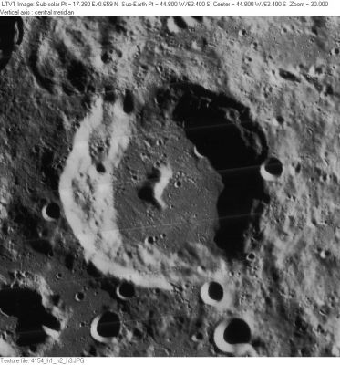
LO-IV-154H Several [/satellite%20feature lettered craters] named after Bettinus are visible here. These include Bettinus F, the 6-km crater on the main crater's northeast floor, nearly covered by shadow; 7-km Bettinus E, on the rim nearby; 8-km Bettinus H, also on the rim at 5 o'clock; 9-km Bettinus D, outside the rim at 7 o'clock; and ragged 26-km Bettinus A in the lower left corner. The 12-km crater along the lower right margin (below Bettinus H) is [/Kircher Kircher] B, named for the nearby crater to the south.
Images
LPOD Photo Gallery Lunar Orbiter Images
Maps
([/LAC%20zone LAC zone] 125D4) LAC map Geologic map USGS Nomenclature maps (PDF): north south
Description
Description: Elger
([/IAU%20Directions IAU Directions]) BETTINUS.--Another ring-plain of the same type and size, some distance S. of [/Zucchius Zuchius], with a massive border, terraced within, and rising on the E. more than 13,000 feet above the floor, on which stands a grand central mountain, whose brilliant summit is in sunlight a long time before a ray reaches any part of the deep interior.
Description: Wikipedia
Additional Information
- Depth data from [/Kurt%20Fisher%20crater%20depths Kurt Fisher database]
- Westfall, 2000: 3.69 km
- Viscardy, 1985: 3.3 km
- Cherrington, 1969: 3.81 km
- [/Central%20peak%20composition Central peak composition]: Anorthosite & GNTA1 ([/Tompkins%20%26%20Pieters%2C%201999 Tompkins & Pieters, 1999])
Nomenclature
- Named for Mario Bettinus (February 6, 1582 - November 7, 1657), an Italian Jesuit philosopher, mathematician and astronomer. His Apiaria Universae Philosophiae Mathematicae is an encyclopedic collection of mathematical curiosities.
- According to [/Whitaker Whitaker] (p. 211), this was one of the original names from [/Riccioli Riccioli]'s map, where it was listed as Bettinus Soc. I (the "Soc. I" standing for "Society of Jesus" -- see the list of [/Nomenclature-Jesuits Jesuit astronomers]).
LPOD Articles
Bibliography
This page has been edited 1 times. The last modification was made by - tychocrater tychocrater on Jun 13, 2009 3:24 pm - afx3u2