Difference between revisions of "Baldet"
(Created page with "<div id="content_view" class="wiki" style="display: block"> =Baldet= {| class="wiki_table" | Lat: 53.3°S, Long: 151.1°W, Diam: 55 km, Depth: km, Rükl: ''(farside)''<br /...") |
|||
| Line 6: | Line 6: | ||
<div id="toc"> | <div id="toc"> | ||
=Table of Contents= | =Table of Contents= | ||
| − | <div style="margin-left: 1em">[#Baldet Baldet]</div><div style="margin-left: 2em">[#Baldet-Images Images]</div><div style="margin-left: 2em">[#Baldet-Maps Maps]</div><div style="margin-left: 2em">[#Baldet-Description Description]</div><div style="margin-left: 2em">[#Baldet-Description: Wikipedia Description: Wikipedia]</div><div style="margin-left: 2em">[#Baldet-Additional Information Additional Information]</div><div style="margin-left: 2em">[#Baldet-Nomenclature Nomenclature]</div><div style="margin-left: 2em">[#Baldet-LPOD Articles LPOD Articles]</div><div style="margin-left: 2em">[#Baldet-Bibliography Bibliography]</div><div style="margin-left: 2em">[#Baldet-Baldet in the Sourcebook Project (William R. Corliss) Baldet in the Sourcebook Project (William R. Corliss)]</div></div>[[Image:Baldet.jpg|Baldet.jpg]][http://www.mapaplanet.org/explorer-bin/explorer.cgi?map=Moon&layers=moon_clementine_multi&R=5&G=3&B=1&info=NO&advoption=YES&lines=300&samples=300&sizeSelector=resolution&Resolution=58&projection=MERC&grid=none&stretch=auto&north=-51.9&south=-54.9&west=-154.4&east=-149.2¢er=-151.8&defaultcenter=on¢er_lat=0 [[Image:imageMaker.cgi|external image jpg&height=300&width=300&bbox=-154.4,-54.9,-149.2,-51.9&resamp_method=nearest_neighbor]]]<br /> left: '''''LROC''''' '''Baldet''' lies inside dark floor '''[ | + | <div style="margin-left: 1em">[#Baldet Baldet]</div><div style="margin-left: 2em">[#Baldet-Images Images]</div><div style="margin-left: 2em">[#Baldet-Maps Maps]</div><div style="margin-left: 2em">[#Baldet-Description Description]</div><div style="margin-left: 2em">[#Baldet-Description: Wikipedia Description: Wikipedia]</div><div style="margin-left: 2em">[#Baldet-Additional Information Additional Information]</div><div style="margin-left: 2em">[#Baldet-Nomenclature Nomenclature]</div><div style="margin-left: 2em">[#Baldet-LPOD Articles LPOD Articles]</div><div style="margin-left: 2em">[#Baldet-Bibliography Bibliography]</div><div style="margin-left: 2em">[#Baldet-Baldet in the Sourcebook Project (William R. Corliss) Baldet in the Sourcebook Project (William R. Corliss)]</div></div>[[Image:Baldet.jpg|Baldet.jpg]][http://www.mapaplanet.org/explorer-bin/explorer.cgi?map=Moon&layers=moon_clementine_multi&R=5&G=3&B=1&info=NO&advoption=YES&lines=300&samples=300&sizeSelector=resolution&Resolution=58&projection=MERC&grid=none&stretch=auto&north=-51.9&south=-54.9&west=-154.4&east=-149.2¢er=-151.8&defaultcenter=on¢er_lat=0 [[Image:imageMaker.cgi|external image jpg&height=300&width=300&bbox=-154.4,-54.9,-149.2,-51.9&resamp_method=nearest_neighbor]]]<br /> left: '''''LROC''''' '''Baldet''' lies inside dark floor '''[[South%20Pole%20-%20Aitken%20Basin|South Pole - Aitken Basin]]'''<br /> right: '''''Clementine UV-VIS Multispectral Mosaic''''': Mercator projection dynamically created by USGS lunar [http://www.mapaplanet.org/explorer/help/wmsUserDoc.html Web Map Service].<br /> <br /> |
==Images== | ==Images== | ||
[http://www.lpod.org/coppermine/thumbnails.php?album=search&type=full&search=Baldet LPOD Photo Gallery] [http://www.lpi.usra.edu/resources/lunar_orbiter/bin/srch_nam.shtml?Baldet%7C0 Lunar Orbiter Images]<br /> <br /> | [http://www.lpod.org/coppermine/thumbnails.php?album=search&type=full&search=Baldet LPOD Photo Gallery] [http://www.lpi.usra.edu/resources/lunar_orbiter/bin/srch_nam.shtml?Baldet%7C0 Lunar Orbiter Images]<br /> <br /> | ||
==Maps== | ==Maps== | ||
| − | ''([ | + | ''([[LAC%20zone|LAC zone]] 133B4)'' [http://planetarynames.wr.usgs.gov/images/Lunar/lac_133.pdf USGS Digital Atlas PDF]<br /> <br /> |
==Description== | ==Description== | ||
<br /> | <br /> | ||
| Line 21: | Line 21: | ||
* [http://en.wikipedia.org/wiki/Fernand_Baldet Fernand Baldet] (March 16, 1885 - November 8, 1964) was a French astronomer. He worked with Count Aymar de la Baume Pluvinel observing Mars from the newly built observatory on Pic du Midi in 1909. The resulting photographs were so sharp, that they were able to disprove Percival Lowell's claim of geometrical canals on the planet's surface. | * [http://en.wikipedia.org/wiki/Fernand_Baldet Fernand Baldet] (March 16, 1885 - November 8, 1964) was a French astronomer. He worked with Count Aymar de la Baume Pluvinel observing Mars from the newly built observatory on Pic du Midi in 1909. The resulting photographs were so sharp, that they were able to disprove Percival Lowell's claim of geometrical canals on the planet's surface. | ||
| − | * Name originally given by Lamech to a different (nearside) crater (Jules Baldet), moved to this one in 1970 ([ | + | * Name originally given by Lamech to a different (nearside) crater (Jules Baldet), moved to this one in 1970 ([[Whitaker|Whitaker]], p 228). |
<br /> | <br /> | ||
==LPOD Articles== | ==LPOD Articles== | ||
Revision as of 15:40, 15 April 2018
Contents
Baldet
| Lat: 53.3°S, Long: 151.1°W, Diam: 55 km, Depth: km, Rükl: (farside) |
Table of Contents
[#Baldet Baldet]
[#Baldet-Images Images]
[#Baldet-Maps Maps]
[#Baldet-Description Description]
[#Baldet-Description: Wikipedia Description: Wikipedia]
[#Baldet-Additional Information Additional Information]
[#Baldet-Nomenclature Nomenclature]
[#Baldet-LPOD Articles LPOD Articles]
[#Baldet-Bibliography Bibliography]
[#Baldet-Baldet in the Sourcebook Project (William R. Corliss) Baldet in the Sourcebook Project (William R. Corliss)]
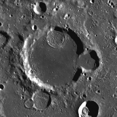
 external image jpg&height=300&width=300&bbox=-154.4,-54.9,-149.2,-51.9&resamp_method=nearest_neighbor
left: LROC Baldet lies inside dark floor South Pole - Aitken Basin
right: Clementine UV-VIS Multispectral Mosaic: Mercator projection dynamically created by USGS lunar Web Map Service.
Images
LPOD Photo Gallery Lunar Orbiter Images
Maps
(LAC zone 133B4) USGS Digital Atlas PDF
Description
Description: Wikipedia
Additional Information
- Floor Fractured Crater (FFC) on the northern part of Baldet's floor. Isn't there a letter designation for this FFC? (Baldet A for example).- DannyCaes DannyCaes Aug 23, 2014
Nomenclature
- Fernand Baldet (March 16, 1885 - November 8, 1964) was a French astronomer. He worked with Count Aymar de la Baume Pluvinel observing Mars from the newly built observatory on Pic du Midi in 1909. The resulting photographs were so sharp, that they were able to disprove Percival Lowell's claim of geometrical canals on the planet's surface.
- Name originally given by Lamech to a different (nearside) crater (Jules Baldet), moved to this one in 1970 (Whitaker, p 228).
LPOD Articles
Bibliography
Baldet in the Sourcebook Project (William R. Corliss)
- Fernand Baldet might be (or might be not?) the same Baldet who's mentioned in the article Comets and Climatic Changes (Nature, 176:1152-1153, 1955); on page 535 of the book Mysterious Universe, a handbook of astronomical anomalies (William R. Corliss, The Sourcebook Project, 1979).
This page has been edited 1 times. The last modification was made by - tychocrater tychocrater on Jun 13, 2009 3:24 pm - afx3u2