Difference between revisions of "Auwers"
(Created page with "<div id="content_view" class="wiki" style="display: block"> =Auwers= {| class="wiki_table" | Lat: 15.1°N, Long: 17.2°E, Diam: 20 km, Depth: 1.68 km, [http://the-moon.wik...") |
|||
| Line 3: | Line 3: | ||
{| class="wiki_table" | {| class="wiki_table" | ||
| | | | ||
| − | Lat: 15.1°N, Long: 17.2°E, Diam: 20 km, Depth: 1.68 km, [http://the-moon. | + | Lat: 15.1°N, Long: 17.2°E, Diam: 20 km, Depth: 1.68 km, [http://the-moon.us/wiki/R%C3%BCkl%2024 Rükl: 24]<br /> |
|} | |} | ||
<div id="toc"> | <div id="toc"> | ||
| Line 11: | Line 11: | ||
[http://www.lpod.org/coppermine/thumbnails.php?album=search&type=full&search=Auwers LPOD Photo Gallery] [http://www.lpi.usra.edu/resources/lunar_orbiter/bin/srch_nam.shtml?Auwers%7C0 Lunar Orbiter Images] [http://www.lpi.usra.edu/resources/apollo/search/feature/?feature=Auwers Apollo Images]<br /> Orbital panoramic ''ITEK''-camera frames which show '''Auwers''', not mentioned in the LPI's list:<br /> [http://www.lpi.usra.edu/resources/apollo/frame/?AS15-P-9896 AS15-P-9896] and [http://www.lpi.usra.edu/resources/apollo/frame/?AS15-P-9901 AS15-P-9901]<br /> Research: Danny Caes<br /> <br /> | [http://www.lpod.org/coppermine/thumbnails.php?album=search&type=full&search=Auwers LPOD Photo Gallery] [http://www.lpi.usra.edu/resources/lunar_orbiter/bin/srch_nam.shtml?Auwers%7C0 Lunar Orbiter Images] [http://www.lpi.usra.edu/resources/apollo/search/feature/?feature=Auwers Apollo Images]<br /> Orbital panoramic ''ITEK''-camera frames which show '''Auwers''', not mentioned in the LPI's list:<br /> [http://www.lpi.usra.edu/resources/apollo/frame/?AS15-P-9896 AS15-P-9896] and [http://www.lpi.usra.edu/resources/apollo/frame/?AS15-P-9901 AS15-P-9901]<br /> Research: Danny Caes<br /> <br /> | ||
==Maps== | ==Maps== | ||
| − | ''([http://the-moon. | + | ''([http://the-moon.us/wiki/LAC%20zone LAC zone] 60A2)'' [http://www.lpi.usra.edu/resources/mapcatalog/LAC/lac60/ LAC map] [http://www.lpi.usra.edu/resources/mapcatalog/usgs/I510/ Geologic map] [http://www.lpi.usra.edu/resources/mapcatalog/LM/lm60/ LM map] [http://www.lpi.usra.edu/resources/mapcatalog/LTO/lto60a2_1/ LTO map]<br /> <br /> |
==Description== | ==Description== | ||
<br /> | <br /> | ||
| Line 17: | Line 17: | ||
[http://en.wikipedia.org/wiki/Auwers_(crater) Auwers]<br /> <br /> | [http://en.wikipedia.org/wiki/Auwers_(crater) Auwers]<br /> <br /> | ||
==Additional Information== | ==Additional Information== | ||
| − | Depth data from [http://the-moon. | + | Depth data from [http://the-moon.us/wiki/Kurt%20Fisher%20crater%20depths Kurt Fisher database]<br /> |
* Arthur, 1974: 1.68 km | * Arthur, 1974: 1.68 km | ||
* Westfall, 2000: 1.07 km | * Westfall, 2000: 1.07 km | ||
| Line 28: | Line 28: | ||
* Named for [http://en.wikipedia.org/wiki/Arthur_Auwers Georg Friedrich Julius Arthur von Auwers] (1838-1915), a German astronomer who specialized in precise measurements of the positions and motions of stars. Auwers was the second [http://www.phys-astro.sonoma.edu/BruceMedalists/Auwers/index.html Bruce Medalist] of the Astronomical Society of the Pacific where extensive links to information about him can be found. | * Named for [http://en.wikipedia.org/wiki/Arthur_Auwers Georg Friedrich Julius Arthur von Auwers] (1838-1915), a German astronomer who specialized in precise measurements of the positions and motions of stars. Auwers was the second [http://www.phys-astro.sonoma.edu/BruceMedalists/Auwers/index.html Bruce Medalist] of the Astronomical Society of the Pacific where extensive links to information about him can be found. | ||
| − | * This feature was Catalog number 594 in the ''[http://the-moon. | + | * This feature was Catalog number 594 in the ''[http://the-moon.us/wiki/Collated%20List Collated List]'', where all three authorities adopted [http://the-moon.us/wiki/Beer%20and%20M%C3%A4dler Beer and Mädler]'s convention of calling it '''[http://the-moon.us/wiki/Menelaus Menelaus] b''' |
| − | * The name was changed to '''Auwers''' in the original IAU nomenclature of ''[http://the-moon. | + | * The name was changed to '''Auwers''' in the original IAU nomenclature of ''[http://the-moon.us/wiki/Named%20Lunar%20Formations Named Lunar Formations]'', adopting a suggestion by [http://the-moon.us/wiki/Krieger Krieger] and [http://the-moon.us/wiki/K%C3%B6nig König]. |
* A dome-like hill at 14° North/ 16°50' East (south of '''Auwers''') is unofficially named '''''Auwers Tholus''''' by D.Caes. On top of that hillock there's a little craterlet. Although [http://www.mapaplanet.org/explorer-bin/explorer.cgi?map=Moon&layers=moon_lo&west=16.3&south=13.2&east=17.5&north=14.5¢er=16.9&defaultcenter=on&grid=none&stretch=auto&projection=MERC&advoption=YES&info=NO&resolution=392 this feature] superficially resembles [http://www.mapaplanet.org/explorer-bin/explorer.cgi?map=Moon&layers=moon_lo&west=311.1&south=41.1&east=312.7&north=42.3¢er=311.9&defaultcenter=on&grid=none&stretch=auto&projection=MERC&advoption=YES&info=NO&resolution=299 Mairan T] (but with a smaller summit pit) in broadband Lunar Orbiter views, they look quite different in the Clementine color ratio maps, so their origins may be different. <span class="membersnap">- [http://www.wikispaces.com/user/view/DannyCaes [[Image:DannyCaes-lg.jpg|16px|DannyCaes]]] [http://www.wikispaces.com/user/view/DannyCaes DannyCaes] <small>Jun 22, 2008</small></span> | * A dome-like hill at 14° North/ 16°50' East (south of '''Auwers''') is unofficially named '''''Auwers Tholus''''' by D.Caes. On top of that hillock there's a little craterlet. Although [http://www.mapaplanet.org/explorer-bin/explorer.cgi?map=Moon&layers=moon_lo&west=16.3&south=13.2&east=17.5&north=14.5¢er=16.9&defaultcenter=on&grid=none&stretch=auto&projection=MERC&advoption=YES&info=NO&resolution=392 this feature] superficially resembles [http://www.mapaplanet.org/explorer-bin/explorer.cgi?map=Moon&layers=moon_lo&west=311.1&south=41.1&east=312.7&north=42.3¢er=311.9&defaultcenter=on&grid=none&stretch=auto&projection=MERC&advoption=YES&info=NO&resolution=299 Mairan T] (but with a smaller summit pit) in broadband Lunar Orbiter views, they look quite different in the Clementine color ratio maps, so their origins may be different. <span class="membersnap">- [http://www.wikispaces.com/user/view/DannyCaes [[Image:DannyCaes-lg.jpg|16px|DannyCaes]]] [http://www.wikispaces.com/user/view/DannyCaes DannyCaes] <small>Jun 22, 2008</small></span> | ||
<br /> | <br /> | ||
Revision as of 20:09, 11 April 2018
Contents
Auwers
|
Lat: 15.1°N, Long: 17.2°E, Diam: 20 km, Depth: 1.68 km, Rükl: 24 |
Table of Contents
[#Auwers Auwers]
[#Auwers-Images Images]
[#Auwers-Maps Maps]
[#Auwers-Description Description]
[#Auwers-Description: Wikipedia Description: Wikipedia]
[#Auwers-Additional Information Additional Information]
[#Auwers-Nomenclature Nomenclature]
[#Auwers-LPOD Articles LPOD Articles]
[#Auwers-Bibliography Bibliography]

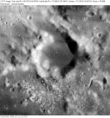
LO-IV-090H
Images
LPOD Photo Gallery Lunar Orbiter Images Apollo Images
Orbital panoramic ITEK-camera frames which show Auwers, not mentioned in the LPI's list:
AS15-P-9896 and AS15-P-9901
Research: Danny Caes
Maps
(LAC zone 60A2) LAC map Geologic map LM map LTO map
Description
Description: Wikipedia
Additional Information
Depth data from Kurt Fisher database
- Arthur, 1974: 1.68 km
- Westfall, 2000: 1.07 km
- Viscardy, 1985: 1.63 km
- Cherrington, 1969: 3.38 km
- In LO-IV-090H, the shadow from the peak on the northeast rim indicates a depth of up to about 1900 m. - JimMosher JimMosher
Nomenclature
- Named for Georg Friedrich Julius Arthur von Auwers (1838-1915), a German astronomer who specialized in precise measurements of the positions and motions of stars. Auwers was the second Bruce Medalist of the Astronomical Society of the Pacific where extensive links to information about him can be found.
- This feature was Catalog number 594 in the Collated List, where all three authorities adopted Beer and Mädler's convention of calling it Menelaus b
- The name was changed to Auwers in the original IAU nomenclature of Named Lunar Formations, adopting a suggestion by Krieger and König.
- A dome-like hill at 14° North/ 16°50' East (south of Auwers) is unofficially named Auwers Tholus by D.Caes. On top of that hillock there's a little craterlet. Although this feature superficially resembles Mairan T (but with a smaller summit pit) in broadband Lunar Orbiter views, they look quite different in the Clementine color ratio maps, so their origins may be different. - DannyCaes DannyCaes Jun 22, 2008
LPOD Articles
Bibliography
This page has been edited 1 times. The last modification was made by - tychocrater tychocrater on Jun 13, 2009 3:24 pm - afx3u2