Hortensius
Contents
Hortensius
|
Lat: 6.45°N, Long: 28.02°W, Diam: 14.16 km, Depth: 2.86 km, [/R%C3%BCkl%2030 Rükl: 30] |
Table of Contents
[#Hortensius Hortensius]
[#Hortensius-Images Images]
[#Hortensius-Maps Maps]
[#Hortensius-Description Description]
[#Hortensius-Description-Elger Elger]
[#Hortensius-Description-Wikipedia Wikipedia]
[#Hortensius-Additional Information Additional Information]
[#Hortensius-Nomenclature Nomenclature]
[#Hortensius-LPOD Articles LPOD Articles]
[#Hortensius-Lunar 100 Lunar 100]
[#Hortensius-Bibliography Bibliography]

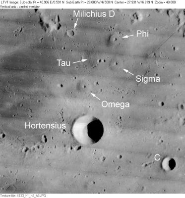
LO-IV-133H Hortensius is the classic flat-bottomed circular crater below center. The 7-km diameter circular crater in the lower right is Hortensius C, and one shallow 4-km crater in the upper left is named after [/Milichius Milichius], as shown. None of the domes, which have what appear to be volcanic caldera at their summits, are officially named, although on chart SLC E4 of the [/System%20of%20Lunar%20Craters System of Lunar Craters] (1966) they had the Greek-lettered designations shown. This cluster was unofficially called the Schlumberger domes. The "six domes" referred to by Phillips (1989) include the one to the west (left) of Omega and a difficult to see one (with no summit pit) to the east of Phi. He also regarded the structure on the groove to the east of this as a dome. Moore and Cattermole saw Phi and its companion-without-summit-pit to the east as a single heart-shaped structure (Phillips, 1989, Fig. 15).
Images
LPOD Photo Gallery Lunar Orbiter Images Apollo Images
- Frame 3123, made by Lunar Orbiter III, shows Hortensius and the nearby domes. Research: Danny Caes.
- Frame 2146, made by Lunar Orbiter II, shows a small hillock (Hortensius Rho; 3°45' north/ 27°50' west) with craterlet on top. Research: Danny Caes.
- The domefield near Hortensius was a favourite target for detailed lunar drawings made by René Schlumberger; a dedicated observer of that area. A drawing made by him (of the Hortensius domefield) was included in the Dutch book [/Op%20Ontdekking%20in%20het%20Maanland Op Ontdekking in het Maanland] by A.J.M. Wanders (1949), Plate XIX. Research: Danny Caes.
- This is probably the same as the wonderful drawing by Schlumberger dated 8-4-1930 that appears on p. 127 of [/Walter%20Goodacre Walter Goodacre]'s The Moon (also reproduced as Figure 12 in Phillips, 1989). - tychocrater tychocrater Jun 24, 2008
Maps
([/LAC%20zone LAC zone] 58D1) LAC map Geologic map AIC map
Description
Elger
([/IAU%20Directions IAU Directions]) HORTENSIUS.--This brilliant crater, about 10 miles in diameter, is remarkable for its depth, and as being a ray-centre surrounded by a nimbus of light. It has a central mountain, and Schmidt shows a minute crater on the outer slope of the S. wall. The former is a test object.
Wikipedia
Additional Information
- IAU page: Hortensius
- Depth data from [/Kurt%20Fisher%20crater%20depths Kurt Fisher database]
- Pike, 1976: 2.86 km
- Arthur, 1974: 2.86 km
- Westfall, 2000: 2.86 km
- Viscardy, 1985: 2.86 km
- From the shadows in LO-IV-133H, the east rim of Hortensius is from 2500-2900 m above the flat-looking floor. - JimMosher JimMosher
- Hortensius A is a thermal anomaly crater, implying a youthful age - [/Moore%20et%20al%2C%201980 Moore et al, 1980]
Nomenclature
- Named for Martin van den Hove (Martinus Hortensius) (1605 — August 7, 1639), a Dutch astronomer and mathematician. Van den Hove developed a method for measuring the diameters of planets based on the measured visual angle that his telescope embraced. Van den Hove corresponded with René [/Descartes Descartes], Marin [/Mersenius Mersenne], Pierre [/Gassendi Gassendi], Christiaan [/Mons%20Huygens Huygens], and Galileo [/Galileo%20Galilei Galilei].
- This name has continued unchanged since its original use for this feature on [/Riccioli Riccioli]'s map ([/Whitaker Whitaker], p. 218).
- None of the domes near Hortensius seem to have been named in the the original [/IAU%20nomenclature IAU nomenclature] of [/Named%20Lunar%20Formations Named Lunar Formations]. Four of them were given Greek-lettered names in the [/System%20of%20Lunar%20Craters System of Lunar Craters] charts; but these were dropped by the IAU in [/IAU%20Transactions%20XVB 1973], and none of them have been officially renamed.
- D. Caes calls the domefield near Hortensius The Hortensius domefield, a name rather similar to that under which it is known in the [/Lunar%20100 Lunar 100].
- Amateur astronomer Jim Phillips (1989, p. 63) dubbed the six most prominent domes immediately north of Hortensius the Schlumberger Domes in recognition of the early drawing of them by René Schlumberger. This is strictly an unofficial name, but has appeared in several subsequent [/ALPO ALPO] publications. - JimMosher JimMosher
LPOD Articles
- Two Weeks in Domeland
- Dome Heights (Hi-Res close up photograph of the Hortensius domes, by the Lunar Reconnaissance Orbiter).
Lunar 100
[/Lunar%20100 L65]: Dome field north of Hortensius.
Bibliography
- Lynn, M. C. et al (2011). A Radar Survey of Lunar Dome Fields. – 42nd LPSC Conference (Mar), 2011.
- Wöhler, C. et al. 2006. A combined spectrophotometric and morphometric study of the lunar mare dome fields near Cauchy, Arago, Hortensius and Milichius. Icarus Volume 183, pp. 237-264. (also avaliable as PDF from author)
- Lena, Raffaello, et al. 2003. The Moon: Domes in the Hortensius region. Journal of the Association of Lunar & Planetary Observers, The Strolling Astronomer, Vol. 45, No. 1, p. 26 - 28 (Winter 2003)
- Hill, Harold. 1991. [/A%20Portfolio%20of%20Lunar%20Drawings A Portfolio of Lunar Drawings], pages 54, 55.
- Phillips, Jim. 1989. The new Lunar Dome Survey - The Hortensius-Milichius-Tobias Mayer region, Journal Association of Lunar and Planetary Observers. Vol. 33, April 1989, pp. 61-72.
[/Alphabetical%20Index Named Features] -- Prev: [/Horrocks Horrocks] -- Next: [/Houssay Houssay]
This page has been edited 1 times. The last modification was made by - tychocrater tychocrater on Jun 13, 2009 3:24 pm - afx3u3