Rimae Pettit
Contents
Rimae Pettit
| Lat: 23.0°S, Long: 92.0°W, Length: 450 km, Depth: km, Rükl: (farside) |
Table of Contents
[#Rimae Pettit Rimae Pettit]
[#Rimae Pettit-Images Images]
[#Rimae Pettit-Maps Maps]
[#Rimae Pettit-Description Description]
[#Rimae Pettit-Description: Wikipedia Description: Wikipedia]
[#Rimae Pettit-Additional Information Additional Information]
[#Rimae Pettit-Nomenclature Nomenclature]
[#Rimae Pettit-LPOD Articles LPOD Articles]
[#Rimae Pettit-Bibliography Bibliography]

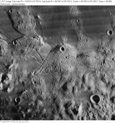
LO-IV-195H The rilles across the middle of this view of the southern part of [/Mare%20Orientale Mare Orientale] are a small part of the larger zone known as Rimae Pettit. However, the ones in the extreme lower left corner are part of a separately-named system: [/Rimae%20Focas Rimae Focas]. The prominent crater is [/Shuleykin Shuleykin]. The other craters are not named.
Images
LPOD Photo Gallery Lunar Orbiter Images
Maps
([/LAC%20zone LAC zone] 108B3) USGS Digital Atlas PDF
Description
Description: Wikipedia
Additional Information
If... Franz von Paula Gruithuisen could have observed the curious crackled region immediately west of Rimae Pettit, how would he have thought about its appearance? (F.v.P.Gruithuisen told the world that he discovered some sort of Lunar City at the somewhat geometrically arranged region north of nearside crater Schroter).
 - DannyCaes DannyCaes Aug 5, 2015
Nomenclature
Named from nearby crater. ([/Pettit Pettit])
LPOD Articles
Bibliography
This page has been edited 1 times. The last modification was made by - tychocrater tychocrater on Jun 13, 2009 3:24 pm - afx3u2