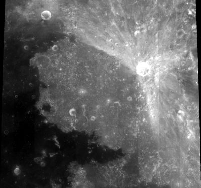
Palus Somni
Contents
Palus Somni
|
Lat: 14.1°N, Long: 45.0°E, Diam: 143 km, Depth: 2.98 km, Rükl: 37 |
Table of Contents
[#Palus Somni Palus Somni]
[#Palus Somni-Images Images]
[#Palus Somni-Maps Maps]
[#Palus Somni-Description Description]
[#Palus Somni-Description: Wikipedia Description: Wikipedia]
[#Palus Somni-Additional Information Additional Information]
[#Palus Somni-Nomenclature Nomenclature]
[#Palus Somni-LPOD Articles LPOD Articles]
[#Palus Somni-Bibliography Bibliography]

Clementine
Images
LPOD Photo Gallery Lunar Orbiter Images Apollo Images
Maps
(LAC zone 61B1) LAC map Geologic map LTO map
Description
Description: Wikipedia
Additional Information
- Area of 17,500 km^2 according to measurements by Jim Whitford-Stark.
- The colour of Palus Somni is peculiar, and has been described as brownish, greenish or yellowish; it is in any case different from that of the Mare Tranquillitatis itself. Source: Patrick Moore's New Guide to the Moon (1976), page 237.- DannyCaes DannyCaes May 19, 2012
- Once called Aestuaria Bamelrodia by Michel Florent van Langren (Langrenus). Now, if someone could tell me more about the origin of the name Bamelrodia (the place on earth called Bamelrodia), that would be most interesting!- DannyCaes DannyCaes Jul 11, 2013 (the name Aestuaria Bamelrodia was printed on page 197 in Ewen A. Whitaker's Mapping and Naming the Moon).
Nomenclature
"Marsh of Sleep".
LPOD Articles
Bibliography
This page has been edited 1 times. The last modification was made by - tychocrater tychocrater on Jun 13, 2009 3:24 pm - afx3u2