Montes Hercynii
Contents
Montes Hercynii
(discontinued [/IAU IAU] name; formerly Hercynian Mts)
| Lat: 23.9°N, Long: 79.5°W, Diam: 145 km, Depth: , Rükl: 17 |
Table of Contents
[#Montes Hercynii Montes Hercynii]
[#Montes Hercynii-Images Images]
[#Montes Hercynii-Maps Maps]
[#Montes Hercynii-Description Description]
[#Montes Hercynii-Description: Elger Description: Elger]
[#Montes Hercynii-Additional Information Additional Information]
[#Montes Hercynii-Nomenclature Nomenclature]
[#Montes Hercynii-LPOD Articles LPOD Articles]
[#Montes Hercynii-Bibliography Bibliography]

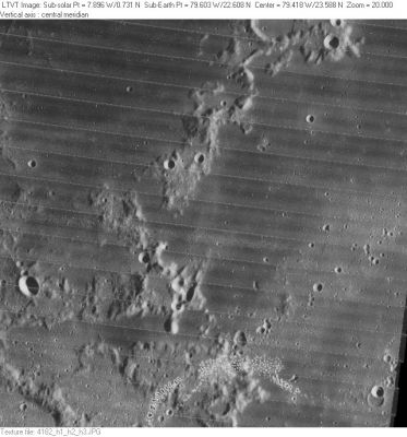
LO-IV-182H This name apparently was applied to the west wall of [/Struve Struve], the 164-km diameter crater that occupies the right half of this image. The smooth-floored crater partially visible along the top edge is 19-km [/Russell Russell] B, and the relatively low arc in the extreme lower left corner is the northeast rim of 62-km [/Balboa Balboa] B. The name Montes Hercynii appears to have embraced at least the central part of the "range" extending between these points; but its exact limits are unclear.
Images
LPOD Photo Gallery Lunar Orbiter Images
Maps
([/LAC%20zone LAC zone] 37C1) LTM map (version 1), LTM Map (version 2), USGS Digital Atlas PDF (see [/Struve Struve])
Description
Description: Elger
([/IAU%20Directions IAU Directions]) Hercynian Mountains, on the north-west limb, west of the walled plain [/Struve Otto Struve]. These are too near the edge to be well observed, but, from what can be seen of them, they appear to abound in lofty peaks, and to bear more resemblance to a terrestrial chain than any which have yet been referred to.
Additional Information
- The position and "diameter" given in the title line refer to the central part of the "range" shown in the [/Lunar%20Orbiter Lunar Orbiter] image. The original name may well have been intended to include the broad peaks at the top and bottom of the frame, in which case the center would be moved about 1 deg to the east, and the diameter increased to about 185 km.
Nomenclature
- Hercynian Mts is said to be an ancient name for the Thüringer Wald Mountains (ref: [/Who%27s%20Who%20in%20the%20Moon Who's Who in the Moon]).
- According to [/Whitaker Whitaker] (p. 220), the name Hercynii Montes was introduced by [/M%C3%A4dler Mädler].
- The name Hercynian Mts was part of the original [/IAU%20nomenclature IAU nomenclature] of [/Blagg%20and%20M%C3%BCller Blagg and Müller] (1935).
- The name was Latinized to Montes Hercynii in [/IAU%20Transactions%20XIIB IAU Transactions XIIB] (1964).
- The name was dropped in [/IAU%20Transactions%20XIVB IAU Transactions XIVB] (1970), where it was declared to be one of five lunar ranges "not clearly identifiable" on images taken from space. Note: [/Whitaker Whitaker] (p. 220) says the name was not used after 1961, but he appears to be in error.
- Assuming the range has been correctly identified here, on modern maps it would be regarded as the west wall of [/Struve Struve].
LPOD Articles
Bibliography
This page has been edited 1 times. The last modification was made by - tychocrater tychocrater on Jun 13, 2009 3:24 pm - afx4