Wrottesley
Contents
Wrottesley
|
Lat: 23.9°S, Long: 56.8°E, Diam: 57 km, Depth: 4.23 km, [/R%C3%BCkl%2059 Rükl: 59] |
Table of Contents

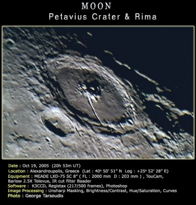
George Tasroudis (Wrottesley is crater in front of Petavius)
Images
LPOD Photo Gallery Lunar Orbiter Images
Wrottesley was photographed by Apollo 15's orbital Mapping/Metric Fairchild camera. This crater near Petavius is visible on Apollo 15's south looking oblique photographs. One such Fairchild frame is AS15-M-2527, in which Wrottesley was captured near the central part of the depicted curved horizon.
Research Danny Caes
Maps
([/LAC%20zone LAC zone] 98A3) LAC map Geologic map
Description
Description: Elger
([/IAU%20Directions IAU Directions]) WROTTESLEY.--A formation, about 25 miles in diameter, closely associated with the W. wall of [/Petavius Petavius], the shape of which it has clearly modified. Its border on the W., of the linear type, rises nearly 9,000 feet above a light interior, where there is a small bright central mountain and some mounds. There is a prominent valley running along the inner slope of the E. wall.
Description: Wikipedia
Additional Information
- Depth data from [/Kurt%20Fisher%20crater%20depths Kurt Fisher database]
- Westfall, 2000: 4.23 km
- Viscardy, 1985: 2.3 km
- Cherrington, 1969: 3.44 km
- Central Peak Height
- [/Sekiguchi%2C%201972 Sekiguchi, 1972]: 1.4 km - fatastronomer fatastronomer
Nomenclature
- Named for John (Baron) Wrottesley (1798-1867), a British astronomer.
- The name was proposed by British amateur [/Birt W. R. Birt] in 1863, in commemoration of the interest the Baron had shown in astronomy.
LPOD Articles
Trenchent observations of a Trench Uninspiring, but an Active History Limb Gift
Bibliography
A Portfolio of Lunar Drawings (Harold Hill), page 216 (the Biot region).
This page has been edited 1 times. The last modification was made by - tychocrater tychocrater on Jun 13, 2009 3:24 pm - afx2u2