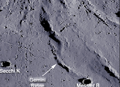
Gemini Ridge
Contents
Gemini Ridge
Lat: 0.07°N, Long: 47.17°E, Diameter: 34.92 km, Depth: km (close, but unofficial data as of April 2017)Table of Contents
[#Gemini Ridge Gemini Ridge]
[#Gemini Ridge-Maps Maps]
[#Gemini Ridge-Description Description]
[#Gemini Ridge-Description: Wikipedia Description: Wikipedia]
[#Gemini Ridge-Additional Information Additional Information]
[#Gemini Ridge-Nomenclature Nomenclature]
[#Gemini Ridge-LROC LROC]
[#Gemini Ridge-LPOD Articles LPOD Articles]
[#Gemini Ridge-Bibliography Bibliography]

Click on image for LROC view or here for a more broader perspective.
Maps
Description
Note, its possible relationship to Dorsa Cato just slightly to its north (perhaps, related stress effects in both?).
Description: Wikipedia
Additional Information
Nomenclature
Gemini Ridge is one of a quite large collection of NASA-related nicknames from the hey-days of the Apollo program, especially the missions of Apollo 10 and Apollo 11. Each one of these nicknames is located near the section of the lunar equator at the eastern part of the moon's near side.
See also the page NASA-related nicknames at the Maskelyne-Secchi region.
The nomenclature overlay from the online LROC ACT-REACT QUICK MAP also shows these nicknames. Worthwile to explore!
LROC
LPOD Articles
Bibliography
This page has been edited 1 times. The last modification was made