Difference between revisions of "Serpentine Ridge"
(Created page with "<div id="content_view" class="wiki" style="display: block"> =Serpentine Ridge= (informal name)<br /> {| class="wiki_table" | Lat: 25°N, Long: 25°E, Length: 500 km, He...") |
|||
| Line 30: | Line 30: | ||
<br /> | <br /> | ||
==LPOD Articles== | ==LPOD Articles== | ||
| − | [http:// | + | [http://www2.lpod.org/wiki/November_17,_2004 A Glorious Serpentine Ridge]<br /> <br /> |
==Bibliography== | ==Bibliography== | ||
<br /> <br /> | <br /> <br /> | ||
---- | ---- | ||
This page has been edited 1 times. The last modification was made by <span class="membersnap">- [http://www.wikispaces.com/user/view/tychocrater [[Image:tychocrater-lg.jpg|16px|tychocrater]]] [http://www.wikispaces.com/user/view/tychocrater tychocrater]</span> on Jun 13, 2009 3:24 pm - ''afx3u2''</div> | This page has been edited 1 times. The last modification was made by <span class="membersnap">- [http://www.wikispaces.com/user/view/tychocrater [[Image:tychocrater-lg.jpg|16px|tychocrater]]] [http://www.wikispaces.com/user/view/tychocrater tychocrater]</span> on Jun 13, 2009 3:24 pm - ''afx3u2''</div> | ||
Revision as of 19:31, 11 April 2018
Contents
Serpentine Ridge
(informal name)
|
Lat: 25°N, Long: 25°E, Length: 500 km, Height: km, [/R%C3%BCkl%2024 Rükl: 24] |
Table of Contents

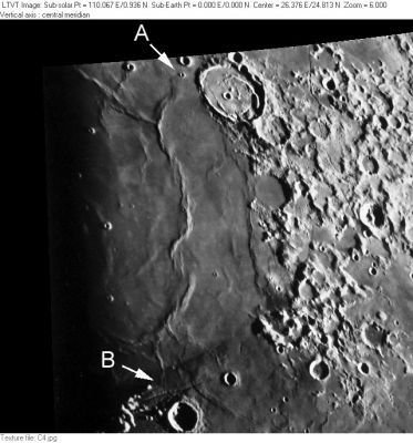
Consolidated Lunar Atlas plate C4 The "Serpentine Ridge" is the long series of mare ridges extending from "A" to "B".
Images
LPOD Photo Gallery Lunar Orbiter Images Apollo Images
- The Serpentine Ridge ([/Dorsa%20Smirnov Dorsa Smirnov]) was frequently photographed during the missions of Apollo 15 and Apollo 17. - DannyCaes DannyCaes Apr 30, 2010
Maps
([/LAC%20zone LAC zone] 42B3) LAC map Geologic map LM map
Description
Description: Elger
([/IAU%20Directions IAU Directions]) [/Mare%20Serenitatis Mare Serenitatis] ... includes besides one of the longest and loftiest (ridges) on the moon's visible surface -- the great serpentine ridge, first drawn and described nearly a hundred years ago by the famous selenographer, Schroter of Lilienthal. Originating at a little crater under the north-west wall of great ring-plain [/Posidonius Posidonius], it follows a winding course across the Mare toward the south, throwing out many minor branches, and ultimately dies out under a great rocky promontory--the [/Promontorium%20Archerusia Promontory Acherusia], at the eastern termination of the [/Montes%20Haemus Haemus range]. A comparatively low power serves to show the curious structural character of this immense ridge, which appears to consist of a number of corrugations and folds massed together, rising in places, according to Neison, to a height of 700 feet and more.
Additional Information
Nomenclature
- Drawn by [/Johann%20Schr%C3%B6ter Johann Schröter] ([/Whitaker Whitaker], Fig. 67, p. 104 -- Schröter's Plate X, observed on November 17, 1789 at 10:10 pm local time). On page 185 of the first volume of his book, Schröter refers to the ridge as a "fortlaufende Bergader" ("fortlaufende" = continuous; "Berg" = mountain; "Ader" = vein, as in coal mining) connecting [/Plinius Plinius] and [/Posidonius Posidonius]. At the bottom of the page he further describes it as "schlangenformig" ("schlangen" = snake/serpent).
- Thanks to - wilfried_tost wilfried_tost for help with the translations (- JimMosher JimMosher)
- Various English observer's picked up on Schröter's descriptive term. For example, on page 180 of an 1868 edition of the Astronomical register, [/Birt Birt] refers to "the well-known serpentine ridge of Schröter." However, like ""Bergader", the term "serpentine" was also used with some indifference as a descriptive term. For example, in various publications [/Elger Elger] refers to "the great Serpentine ridge", but there is little other than the extra adjective "great" to distinguish this from Elger's serpentine ridges in Mare Frigoris and near Langrenus.
- Although this feature was drawn on the maps of [/Blagg%20and%20M%C3%BCller Blagg and Müller], it was not named by them. Several features along it did have IAU-approved names: Posidonius Gamma (the elevated region around [/Posidonius Posidonius] Y -- regarded as a "crater cone"), the crater [/Very Very] (Le Monnier B), and [/Bessel Bessel] Alpha (an elevated point to the south of [/Very Very] which no longer has an official name).
- In the modern [/IAU%20nomenclature IAU nomenclature], the Serpentine Ridge corresponds to [/Dorsum%20Nicol Dorsum Nicol], portions of [/Dorsa%20Lister Dorsa Lister], [/Dorsa%20Smirnov Dorsa Smirnov], and an unnamed northward extension of that ridge ending near [/Posidonius Posidonius] F.
LPOD Articles
Bibliography
This page has been edited 1 times. The last modification was made by - tychocrater tychocrater on Jun 13, 2009 3:24 pm - afx3u2