Difference between revisions of "Dorsum Oppel"
| Line 11: | Line 11: | ||
|} | |} | ||
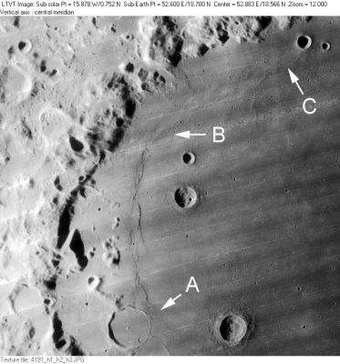
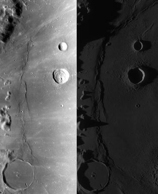
'''Left:''' ''[http://lpod.org/coppermine/displayimage.php?pos=-2772 LO-IV-191H]'' The IAU’s '''Dorsum Oppel''' runs at least from point “A” to point “B”, and probably continues to point “C” (see '''Nomenclature'''). Other IAU-named features visible in this [http://the-moon.us/wiki/Lunar%20Orbiter Lunar Orbiter] view of the western shore of [http://the-moon.us/wiki/Mare%20Crisium Mare Crisium] include 36-km [http://the-moon.us/wiki/Yerkes Yerkes] (the ghost crater at “A”), [http://the-moon.us/wiki/Picard Picard] (the 22-km crater to the east of [http://the-moon.us/wiki/Yerkes Yerkes]), [http://the-moon.us/wiki/Curtis Curtis] (the 2-km bright-haloed crater to the east of [http://the-moon.us/wiki/Picard Picard]), 10-km [http://the-moon.us/wiki/Swift Swift] (circular crater below the “B” arrow), and 18-km [http://the-moon.us/wiki/Peirce Peirce] (below [http://the-moon.us/wiki/Swift Swift]). The circular craters above the “C” are '''[http://the-moon.us/wiki/Cleomedes Cleomedes] F''' (12-km) and '''[http://the-moon.us/wiki/Cleomedes Cleomedes] H''' (6 km).<br /> '''Right:''' Two ''[http://lroc.sese.asu.edu/index.html LROC]'' views (WAC No.'s [http://wms.lroc.asu.edu/lroc/view_lroc/LRO-L-LROC-2-EDR-V1.0/M119510188ME M119510188ME] and [http://wms.lroc.asu.edu/lroc/view_lroc/LRO-L-LROC-2-EDR-V1.0/M117148689ME M117148689ME]) of the region under different lighting conditions. Both images calibrated by [http://ltvt.wikispaces.com/Utility%20Programs#WAC_Viewer LROC_WAC_Previewer].<br /> <br /> <div id="toc"> | '''Left:''' ''[http://lpod.org/coppermine/displayimage.php?pos=-2772 LO-IV-191H]'' The IAU’s '''Dorsum Oppel''' runs at least from point “A” to point “B”, and probably continues to point “C” (see '''Nomenclature'''). Other IAU-named features visible in this [http://the-moon.us/wiki/Lunar%20Orbiter Lunar Orbiter] view of the western shore of [http://the-moon.us/wiki/Mare%20Crisium Mare Crisium] include 36-km [http://the-moon.us/wiki/Yerkes Yerkes] (the ghost crater at “A”), [http://the-moon.us/wiki/Picard Picard] (the 22-km crater to the east of [http://the-moon.us/wiki/Yerkes Yerkes]), [http://the-moon.us/wiki/Curtis Curtis] (the 2-km bright-haloed crater to the east of [http://the-moon.us/wiki/Picard Picard]), 10-km [http://the-moon.us/wiki/Swift Swift] (circular crater below the “B” arrow), and 18-km [http://the-moon.us/wiki/Peirce Peirce] (below [http://the-moon.us/wiki/Swift Swift]). The circular craters above the “C” are '''[http://the-moon.us/wiki/Cleomedes Cleomedes] F''' (12-km) and '''[http://the-moon.us/wiki/Cleomedes Cleomedes] H''' (6 km).<br /> '''Right:''' Two ''[http://lroc.sese.asu.edu/index.html LROC]'' views (WAC No.'s [http://wms.lroc.asu.edu/lroc/view_lroc/LRO-L-LROC-2-EDR-V1.0/M119510188ME M119510188ME] and [http://wms.lroc.asu.edu/lroc/view_lroc/LRO-L-LROC-2-EDR-V1.0/M117148689ME M117148689ME]) of the region under different lighting conditions. Both images calibrated by [http://ltvt.wikispaces.com/Utility%20Programs#WAC_Viewer LROC_WAC_Previewer].<br /> <br /> <div id="toc"> | ||
| − | + | ||
| − | |||
==Images== | ==Images== | ||
[http://www.lpod.org/coppermine/thumbnails.php?album=search&type=full&search=Dorsum%20Oppel LPOD Photo Gallery] [http://www.lpi.usra.edu/resources/lunar_orbiter/bin/srch_nam.shtml?Dorsum%20Oppel%7C0 Lunar Orbiter Images] [http://www.lpi.usra.edu/resources/apollo/search/feature/?feature=Dorsum%20Oppel Apollo Images]<br /> - The arc of '''Dorsum Oppel''' is noticeable near the centre of Apollo 17's vertical mapping/metric ''Fairchild'' camera photograph [http://www.lpi.usra.edu/resources/apollo/frame/?AS17-M-0290 AS17-M-0290] (north toward the frame's right margin).<br /> - '''Dorsum Oppel''''s A-to-B section was also captured on Apollo 17's orbital panoramic ''ITEK''-camera frames [http://www.lpi.usra.edu/resources/apollo/frame/?AS17-P-2253 AS17-P-2253] and [http://www.lpi.usra.edu/resources/apollo/frame/?AS17-P-2258 2258].<br /> - Additional research Apollo 17 photography: Danny Caes<br /> <br /> | [http://www.lpod.org/coppermine/thumbnails.php?album=search&type=full&search=Dorsum%20Oppel LPOD Photo Gallery] [http://www.lpi.usra.edu/resources/lunar_orbiter/bin/srch_nam.shtml?Dorsum%20Oppel%7C0 Lunar Orbiter Images] [http://www.lpi.usra.edu/resources/apollo/search/feature/?feature=Dorsum%20Oppel Apollo Images]<br /> - The arc of '''Dorsum Oppel''' is noticeable near the centre of Apollo 17's vertical mapping/metric ''Fairchild'' camera photograph [http://www.lpi.usra.edu/resources/apollo/frame/?AS17-M-0290 AS17-M-0290] (north toward the frame's right margin).<br /> - '''Dorsum Oppel''''s A-to-B section was also captured on Apollo 17's orbital panoramic ''ITEK''-camera frames [http://www.lpi.usra.edu/resources/apollo/frame/?AS17-P-2253 AS17-P-2253] and [http://www.lpi.usra.edu/resources/apollo/frame/?AS17-P-2258 2258].<br /> - Additional research Apollo 17 photography: Danny Caes<br /> <br /> | ||
| Line 33: | Line 32: | ||
<br /> <br /> | <br /> <br /> | ||
---- | ---- | ||
| − | + | </div> | |
Revision as of 16:20, 15 April 2018
Contents
Dorsum Oppel
|
Lat: 18.7°N, Long: 52.6°E, Length: 268 km, Height: km, Rükl: 26 | |
Right: Two LROC views (WAC No.'s M119510188ME and M117148689ME) of the region under different lighting conditions. Both images calibrated by LROC_WAC_Previewer.
Images
LPOD Photo Gallery Lunar Orbiter Images Apollo Images
- The arc of Dorsum Oppel is noticeable near the centre of Apollo 17's vertical mapping/metric Fairchild camera photograph AS17-M-0290 (north toward the frame's right margin).
- Dorsum Oppel's A-to-B section was also captured on Apollo 17's orbital panoramic ITEK-camera frames AS17-P-2253 and 2258.
- Additional research Apollo 17 photography: Danny Caes
Maps
(LAC zone 44D4) LAC map Geologic map LTO map
Description
Description: Wikipedia
Additional Information
Nomenclature
Albert; German palaeontologist (1831-1865).
- Dorsum Oppel was among the many provisional dorsa names appearing on NASA’s LTO charts that were approved by the IAU “as now assigned and printed” (on those charts) in IAU Transactions XVIB. It is labeled on LTO-62A1 and LTO-44D4 . Unfortunately LTO-44D4 terminates at the point “B”, and there is neither an LTO nor an LM chart of the region north of that. Since the ridge continues unbroken to the north of “B” one can only assume the IAU meant the name Dorsum Oppel to apply to its full length, which reaches to roughly point “C” (near Cleomedes F). However, since the IAU approved the name as “assigned” on the LTO, and since there is no LTO of this region, the northern extent of Dorsum Oppel is ambiguous.
- The position and diameter currently listed for Dorsum Oppel in the on-line IAU Planetary Gazetteer (and repeated on the title line of this page) seem to be based on the assumption that Dorsum Oppel was meant to extend from “A” to “C”.
LPOD Articles
Bibliography

