Difference between revisions of "Froelich"
| Line 5: | Line 5: | ||
|} | |} | ||
<div id="toc"> | <div id="toc"> | ||
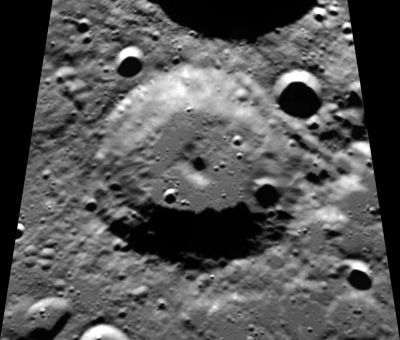
| − | [http://www.lpod.org/coppermine/displayimage.php?pid=2189&fullsize=1 [[Image: | + | [http://www.lpod.org/coppermine/displayimage.php?pid=2189&fullsize=1 [[Image:Normal_froelich-clem1.jpg|external image normal_froelich-clem1.jpg]]]<br /> ''[http://lpod.org/coppermine/displayimage.php?pos=-2189 Clementine]''<br /> <br /> |
==Images== | ==Images== | ||
[http://www.lpod.org/coppermine/thumbnails.php?album=search&type=full&search=Froelich LPOD Photo Gallery] [http://www.lpi.usra.edu/resources/lunar_orbiter/bin/srch_nam.shtml?Froelich%7C0 Lunar Orbiter Images]<br /> <br /> | [http://www.lpod.org/coppermine/thumbnails.php?album=search&type=full&search=Froelich LPOD Photo Gallery] [http://www.lpi.usra.edu/resources/lunar_orbiter/bin/srch_nam.shtml?Froelich%7C0 Lunar Orbiter Images]<br /> <br /> | ||
Latest revision as of 01:49, 16 April 2018
Contents
Froelich
| Lat: 80.3°N, Long: 109.7°W, Diam: 58 km, Depth: 3.4 km, Rükl: (farside) |
Images
LPOD Photo Gallery Lunar Orbiter Images
Maps
(LAC zone 1C4) USGS Digital Atlas PDF
Description
Description: Wikipedia
Additional Information
- The valley at the northeastern part of Froelich's rim is unofficially called Vallis Froelich by D.Caes. Note that this valley could be the most western continuation of the much longer "Vallis Sylvester" between Sylvester and Brianchon. Research: Danny Caes.
- Measures on LRO QuickMap give max depth about 3.4 km
Nomenclature
Jack Edward (Froehlich); American rocket scientist (1921-1967).
LPOD Articles
Bibliography
