Difference between revisions of "Virtanen"
(Created page with "<div id="content_view" class="wiki" style="display: block"> =Virtanen= {| class="wiki_table" | Lat: 15.5°N, Long: 176.7°E, Diam: 44 km, Depth: km, Rükl: ''(farside)'',...") |
|||
| (3 intermediate revisions by the same user not shown) | |||
| Line 3: | Line 3: | ||
{| class="wiki_table" | {| class="wiki_table" | ||
| | | | ||
| − | Lat: 15.5°N, Long: 176.7°E, Diam: 44 km, Depth: km, Rükl: ''(farside)'', [http://the-moon. | + | Lat: 15.5°N, Long: 176.7°E, Diam: 44 km, Depth: km, Rükl: ''(farside)'', [http://the-moon.us/wiki/Stratigraphy Eratosthenian]<br /> |
|} | |} | ||
<div id="toc"> | <div id="toc"> | ||
| − | + | [http://www.mapaplanet.org/explorer-bin/explorer.cgi?map=Moon&layers=moon_clementine_bw&info=NO&advoption=YES&lines=300&samples=300&sizeSelector=resolution&Resolution=129&projection=MERC&grid=none&stretch=auto&north=16.7&south=14.5&west=175.5&east=177.9¢er=176.7&defaultcenter=on¢er_lat=0 [[Image:Virtanen.t.jpg|external image jpg&height=300&width=300&bbox=175.5,14.5,177.9,16.7&resamp_method=nearest_neighbor]]]<br /> '''''Clementine Greyscale Basemap''''': Mercator projection dynamically created by USGS lunar [http://www.mapaplanet.org/explorer/help/wmsUserDoc.html Web Map Service]. Click [http://planetarynames.wr.usgs.gov/jsp/AdvanceSearch2.jsp?body=Moon&ft=ALL&nlat=16.7&slat=14.5&wlon=175.5&elon=177.9&lonDirection=EAST&as=ANY&sort=AName&ShowType=Yes&ShowDiam=Yes&ShowLat=Yes&ShowLon=Yes&ShowAD=Yes here] for a USGS-generated list of all [http://the-moon.us/wiki/IAU IAU]-named features with centers in the current field.<br /> <br /> | |
| − | |||
==Images== | ==Images== | ||
[http://www.lpod.org/coppermine/thumbnails.php?album=search&type=full&search=Virtanen LPOD Photo Gallery] [http://www.lpi.usra.edu/resources/lunar_orbiter/bin/srch_nam.shtml?Virtanen%7C0 Lunar Orbiter Images] [http://www.lpi.usra.edu/resources/apollo/search/feature/?feature=Virtanen Apollo Images]<br /> - The [http://www.lpi.usra.edu/resources/lunar_orbiter/images/aimg/ii_034_m.jpg red labeled Lunar Orbiter 2 photograph LO-II 034 Med] shows the name '''Safarik''' ("'''Safavrik'''") at the location of crater '''Virtanen''', which is too northward! (south-southeast of '''Lacus Luxuriae''' and '''Buys-Ballot'''). '''Safarik''''s location is east-southeast of '''Sharonov''', and north of '''Tiselius'''.<br /> - HiRes scan of [http://www.lpi.usra.edu/resources/lunarorbiter/images/preview/2034_h1.jpg LO-II 034 h1] which shows '''Virtanen''' near the frame's lower left corner. The largest crater in this frame is '''Sharonov''' (south upward).<br /> - Additional research: Danny Caes<br /> <br /> | [http://www.lpod.org/coppermine/thumbnails.php?album=search&type=full&search=Virtanen LPOD Photo Gallery] [http://www.lpi.usra.edu/resources/lunar_orbiter/bin/srch_nam.shtml?Virtanen%7C0 Lunar Orbiter Images] [http://www.lpi.usra.edu/resources/apollo/search/feature/?feature=Virtanen Apollo Images]<br /> - The [http://www.lpi.usra.edu/resources/lunar_orbiter/images/aimg/ii_034_m.jpg red labeled Lunar Orbiter 2 photograph LO-II 034 Med] shows the name '''Safarik''' ("'''Safavrik'''") at the location of crater '''Virtanen''', which is too northward! (south-southeast of '''Lacus Luxuriae''' and '''Buys-Ballot'''). '''Safarik''''s location is east-southeast of '''Sharonov''', and north of '''Tiselius'''.<br /> - HiRes scan of [http://www.lpi.usra.edu/resources/lunarorbiter/images/preview/2034_h1.jpg LO-II 034 h1] which shows '''Virtanen''' near the frame's lower left corner. The largest crater in this frame is '''Sharonov''' (south upward).<br /> - Additional research: Danny Caes<br /> <br /> | ||
==Maps== | ==Maps== | ||
| − | ''([http://the-moon. | + | ''([http://the-moon.us/wiki/LAC%20zone LAC zone] 68A2)'' [http://planetarynames.wr.usgs.gov/images/Lunar/lac_68.pdf USGS Digital Atlas PDF]<br /> <br /> |
==Description== | ==Description== | ||
<br /> | <br /> | ||
| Line 23: | Line 22: | ||
<br /> | <br /> | ||
==Exploring the LROC's NAC close-ups of Virtanen F== | ==Exploring the LROC's NAC close-ups of Virtanen F== | ||
| − | Thanks John Moore! (news about the IAU's '''Virtanen F'''). This news is an interesting spark to start an exploration of the interior of that (rather unknown) crater!<br /> The ACT-REACT QUICK MAP on the LROC-site shows wonderful NAC close-ups of that crater! Lots of chaotic lava-flow like details with numerous cracks and ''crevasses'' all over the slopes!<br /> Thanks! <span class="membersnap">- | + | Thanks John Moore! (news about the IAU's '''Virtanen F'''). This news is an interesting spark to start an exploration of the interior of that (rather unknown) crater!<br /> The ACT-REACT QUICK MAP on the LROC-site shows wonderful NAC close-ups of that crater! Lots of chaotic lava-flow like details with numerous cracks and ''crevasses'' all over the slopes!<br /> Thanks! <span class="membersnap">- DannyCaes <small>May 4, 2017</small></span><br /> <br /> |
==LPOD Articles== | ==LPOD Articles== | ||
[http://lpod.wikispaces.com/November%2011%2C%202012 Shooting Sideways]<br /> | [http://lpod.wikispaces.com/November%2011%2C%202012 Shooting Sideways]<br /> | ||
| Line 29: | Line 28: | ||
<br /> <br /> | <br /> <br /> | ||
---- | ---- | ||
| − | + | </div> | |
Latest revision as of 14:26, 22 April 2018
Contents
Virtanen
|
Lat: 15.5°N, Long: 176.7°E, Diam: 44 km, Depth: km, Rükl: (farside), Eratosthenian |

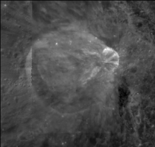
Clementine Greyscale Basemap: Mercator projection dynamically created by USGS lunar Web Map Service. Click here for a USGS-generated list of all IAU-named features with centers in the current field.
Images
LPOD Photo Gallery Lunar Orbiter Images Apollo Images
- The red labeled Lunar Orbiter 2 photograph LO-II 034 Med shows the name Safarik ("Safavrik") at the location of crater Virtanen, which is too northward! (south-southeast of Lacus Luxuriae and Buys-Ballot). Safarik's location is east-southeast of Sharonov, and north of Tiselius.
- HiRes scan of LO-II 034 h1 which shows Virtanen near the frame's lower left corner. The largest crater in this frame is Sharonov (south upward).
- Additional research: Danny Caes
Maps
(LAC zone 68A2) USGS Digital Atlas PDF
Description
Description: Wikipedia
Additional Information
Considered to be Copernican by Moore and McEwen (LPSC XXVII, #1450), but rays seems to be from later crater on Virtanen's rim.
Nomenclature
- Artturi Ilmari Virtanen (January 15, 1895 - November 11, 1973) was a Finnish agricultural biochemist. In 1945, Virtanen became a Nobel Prize laureate in chemistry "for his research and inventions in agricultural and nutrition chemistry”.
- On the 2 May 2017, the IAU approved the crater on/within Virtanen's eastern sector as Virtanen F (the first approved in 2017 at Lat: 15.79°N, Long: 177.32°E, Diam: 11.6 km).
Exploring the LROC's NAC close-ups of Virtanen F
Thanks John Moore! (news about the IAU's Virtanen F). This news is an interesting spark to start an exploration of the interior of that (rather unknown) crater!
  The ACT-REACT QUICK MAP on the LROC-site shows wonderful NAC close-ups of that crater! Lots of chaotic lava-flow like details with numerous cracks and crevasses all over the slopes!
  Thanks! - DannyCaes May 4, 2017
LPOD Articles
Bibliography