Difference between revisions of "Mutus"
(Created page with "<div id="content_view" class="wiki" style="display: block"> =Mutus= {| class="wiki_table" | Lat: 63.6°S, Long: 30.1°E, Diam: 77 km, Depth: 3.58 km, Rükl: 74, pre-Nectari...") |
|||
| (3 intermediate revisions by the same user not shown) | |||
| Line 5: | Line 5: | ||
|} | |} | ||
<div id="toc"> | <div id="toc"> | ||
| − | + | [http://www.lpod.org/coppermine/displayimage.php?pid=207&fullsize=1 [[Image:Normal_Boussingault-2.JPG|external image normal_Boussingault-2.JPG]]]<br /> ''[http://lpod.org/coppermine/displayimage.php?pos=-207 Eric Roel]; Mutus is the crater at the bottom left.''<br /> <br /> | |
| − | |||
==Images== | ==Images== | ||
[http://www.lpod.org/coppermine/thumbnails.php?album=search&type=full&search=Mutus LPOD Photo Gallery] [http://www.lpi.usra.edu/resources/lunar_orbiter/bin/srch_nam.shtml?Mutus%7C0 Lunar Orbiter Images] [http://www.lpi.usra.edu/resources/apollo/search/feature/?feature=Mutus Apollo Images]<br /> <br /> | [http://www.lpod.org/coppermine/thumbnails.php?album=search&type=full&search=Mutus LPOD Photo Gallery] [http://www.lpi.usra.edu/resources/lunar_orbiter/bin/srch_nam.shtml?Mutus%7C0 Lunar Orbiter Images] [http://www.lpi.usra.edu/resources/apollo/search/feature/?feature=Mutus Apollo Images]<br /> <br /> | ||
==Maps== | ==Maps== | ||
| − | ''([ | + | ''([[LAC%20zone|LAC zone]] 127C4)'' [http://www.lpi.usra.edu/resources/mapcatalog/LAC/lac127/ LAC map] [http://www.lpi.usra.edu/resources/mapcatalog/usgs/I702/ Geologic map]<br /> <br /> |
==Description== | ==Description== | ||
<br /> | <br /> | ||
==Description: Elger== | ==Description: Elger== | ||
| − | ''([ | + | ''([[IAU%20directions|IAU Directions]])'' MUTUS.--A fine but foreshortened walled plain, 51 miles in diameter. There are two ring-plains of about equal size on the floor, one on the N., and the other on the S. side. The wall on the E. rises to nearly 14,000 feet above the interior.<br /> <br /> |
==Description: Wikipedia== | ==Description: Wikipedia== | ||
[http://en.wikipedia.org/wiki/Mutus_(crater) Mutus]<br /> <br /> | [http://en.wikipedia.org/wiki/Mutus_(crater) Mutus]<br /> <br /> | ||
==Additional Information== | ==Additional Information== | ||
| − | Depth data from [ | + | Depth data from [[Kurt%20Fisher%20Crater%20Depths|Kurt Fisher database]]<br /> |
* Westfall, 2000: 3.58 km | * Westfall, 2000: 3.58 km | ||
* Viscardy, 1985: 3.7 km | * Viscardy, 1985: 3.7 km | ||
| Line 29: | Line 28: | ||
<br /> | <br /> | ||
==LPOD Articles== | ==LPOD Articles== | ||
| − | [http:// | + | [http://www2.lpod.org/wiki/July_13,_2004 A Strange Depression]<br /> [http://www2.lpod.org/wiki/October_4,_2006 A Second Discovery]<br /> <br /> |
==Bibliography== | ==Bibliography== | ||
<br /> <br /> | <br /> <br /> | ||
---- | ---- | ||
| − | + | </div> | |
Latest revision as of 02:06, 16 April 2018
Contents
Mutus
| Lat: 63.6°S, Long: 30.1°E, Diam: 77 km, Depth: 3.58 km, Rükl: 74, pre-Nectarian |
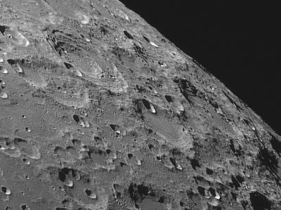
Eric Roel; Mutus is the crater at the bottom left.
Images
LPOD Photo Gallery Lunar Orbiter Images Apollo Images
Maps
(LAC zone 127C4) LAC map Geologic map
Description
Description: Elger
(IAU Directions) MUTUS.--A fine but foreshortened walled plain, 51 miles in diameter. There are two ring-plains of about equal size on the floor, one on the N., and the other on the S. side. The wall on the E. rises to nearly 14,000 feet above the interior.
Description: Wikipedia
Additional Information
Depth data from Kurt Fisher database
- Westfall, 2000: 3.58 km
- Viscardy, 1985: 3.7 km
- Cherrington, 1969: 2.89 km
What was the "mechanism" of the creation of Mutus W? See: http://bit.ly/2BKg9S0 (were there two impacts involved?).
Nomenclature
- Vicente Mut (or Muth) Armengol (1614 - ca. 1687) was a Spanish Writer, lawyer, solider and astronomer. He studied the sciences, but emphasized the field of astronomy, elaborating on works of many other notable astronomers.
- Named by Riccioli (1651)
LPOD Articles
A Strange Depression
A Second Discovery
Bibliography
