Difference between revisions of "Necho"
| Line 6: | Line 6: | ||
|- | |- | ||
| | | | ||
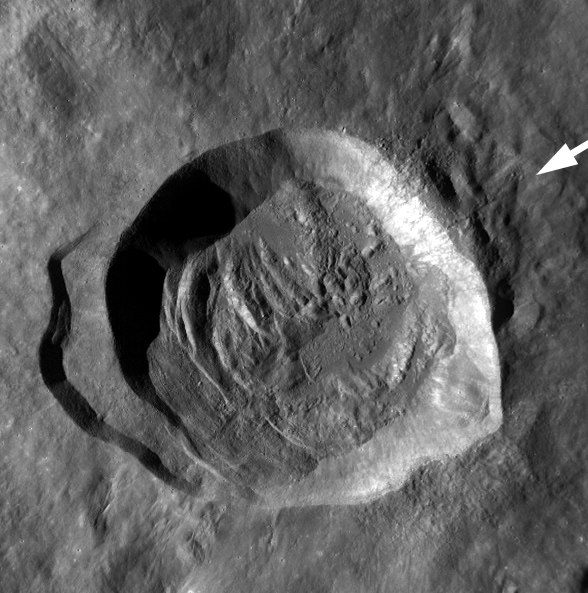
| − | [http://lroc.sese.asu.edu/news/uploads/LROCiotw/M119048299ME.bwmos.png [[Image: | + | [http://lroc.sese.asu.edu/news/uploads/LROCiotw/M119048299ME.bwmos.png [[Image:Necho.jpg|necho.jpg]]]<br /> |
| | | | ||
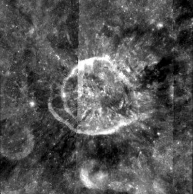
| − | [http://www.lpod.org/coppermine/displayimage.php?pid=1218&fullsize=1 [[Image: | + | [http://www.lpod.org/coppermine/displayimage.php?pid=1218&fullsize=1 [[Image:Normal_necho-clem1.jpg|external image normal_necho-clem1.jpg]]]<br /> |
|} | |} | ||
'''Left:''' Wide Angle Camera ([http://wms.lroc.asu.edu/lroc/view_lroc/LRO-L-LROC-2-EDR-V1.0/M119048299ME WAC M119048299ME]) view from the ''[http://lroc.sese.asu.edu/index.html LRO]'' team at NASA/GSFC/Arizona State University.<br /> '''Right:''' ''[http://lpod.org/coppermine/displayimage.php?pos=-1218 Clementine]''view.<br /> <div id="toc"> | '''Left:''' Wide Angle Camera ([http://wms.lroc.asu.edu/lroc/view_lroc/LRO-L-LROC-2-EDR-V1.0/M119048299ME WAC M119048299ME]) view from the ''[http://lroc.sese.asu.edu/index.html LRO]'' team at NASA/GSFC/Arizona State University.<br /> '''Right:''' ''[http://lpod.org/coppermine/displayimage.php?pos=-1218 Clementine]''view.<br /> <div id="toc"> | ||
| Line 31: | Line 31: | ||
==Additional Information== | ==Additional Information== | ||
| − | * Depth data from [http://the-moon.us/wiki/Kurt%20Fisher% | + | * Depth data from [http://the-moon.us/wiki/Kurt%20Fisher%20Crater%20Depths Kurt Fisher database] |
** Pike, 1976: 3.3 km | ** Pike, 1976: 3.3 km | ||
* Exterior impact melt deposits most extensive to NE, max of ~12 km beyond rim, and topographically lowest rim crest to NE ([http://the-moon.us/wiki/Hawke%20and%20Head%2C%201977 Hawke and Head, 1977]). | * Exterior impact melt deposits most extensive to NE, max of ~12 km beyond rim, and topographically lowest rim crest to NE ([http://the-moon.us/wiki/Hawke%20and%20Head%2C%201977 Hawke and Head, 1977]). | ||
Latest revision as of 02:07, 16 April 2018
Contents
Necho
|
Lat: 5.0°S, Long: 123.1°E, Diam: 30 km, Depth: 3.3 km, Rükl: (farside), Copernician | |
Right: Clementineview.
Images
LPOD Photo Gallery Lunar Orbiter Images Apollo Images
- Although there seems to be nothing in the LPI's list of orbital Apollo photographs of the crater called Necho, it WAS frequently photographed during several of the Apollo project's missions! The list of orbital Apollo photographs of Necho would be much too long to add it into this page! - DannyCaes Jul 29, 2010
- Several orbital Apollo photographs of Necho
- Three oblique south looking photographs of Necho, made during the mission of Apollo 10: AS10-28-4012, AS10-28-4015 and 4016.
- Another trio of oblique south looking photographs of Necho: AS10-33-4873, 4874, and 4875.
- See also AS10-33-4879.
- Most orbital photographs of Necho seem to have been made as sequences of triplets: AS10-33-4988, 4989, and 4990.
- AS10-27-3909 doesn't show Tycho (as mentioned in the caption), it's Necho!
- Research: Danny Caes
- Several orbital Apollo photographs of Necho
Maps
(LAC zone 83B4) LTO map
IAU page
Description
Description: Wikipedia
Additional Information
- Depth data from Kurt Fisher database
- Pike, 1976: 3.3 km
- Exterior impact melt deposits most extensive to NE, max of ~12 km beyond rim, and topographically lowest rim crest to NE (Hawke and Head, 1977).
- Oblique impact crater based on rim profile (Forsberg, Herrick & Bussey, 2008).
- In NASA SP-232 (Analysis of Apollo 10 Photography and Visual Observations) it (crater Necho) is mentioned as Target of Opportunity N°45 (T/O 45).
Nomenclature
- Named for Necho II, a king of the Twenty-sixth dynasty of Egypt (610 - 595 BC), and the son of Psammetichus I. Necho played a significant role in the histories of the Assyrian Empire, Babylonia and the Kingdom of Judah. According to Farouk El-Baz, Necho was also a pioneer geographer who commissioned a successful three-year naval expedition to show that Africa was surrounded by water on all sides.
- This name was officially proposed (and claimed to be accepted) by El-Baz in an article appearing in the journal Science in 1973. The feature to which he attached this name was a purported 200-km diameter crater centered at 3°S/125°E and including the present Becvár, among others.
- Necho was was among the crater names approved "as assigned on the moon" in IAU Transactions XVIB (1976), however the position was given as 5.0°S, 123.0°E, an apparent reference to the present crater rather than to the larger one described by El-Baz.
- The crater officially known as Necho was informally called Roosa on page 28-9 (figure 28-8) of NASA's APOLLO 17 PRELIMINARY SCIENCE REPORT. On that photograph (fig 28-8) the name Necho was printed on a nameless crater west of Becvár. Research: Danny Caes. Roosa was possibly Stuart Roosa (1933-1994), NASA astronaut, Command Module Pilot of Apollo 14.
- In Chapter 5 (Craters, part 4 of 6) of NASA SP-362 APOLLO OVER THE MOON; A VIEW FROM ORBIT, it is noted that Necho was nicknamed "The Bright One" by the astronauts of Apollo 14. Research: Danny Caes.
LRO Articles
A molten flood
Necho's Terraces
Necho's jumbled floor
Impact melt at Necho crater
LPOD Articles
Necho's Peculiar Rays
Abusing Rocks
Bibliography

