Difference between revisions of "Rhaeticus"
| Line 3: | Line 3: | ||
{| class="wiki_table" | {| class="wiki_table" | ||
| | | | ||
| − | Lat: 0.0°N, Long: 4.9°E, Diam: 45 km, Depth: 1.2 km, [ | + | Lat: 0.0°N, Long: 4.9°E, Diam: 45 km, Depth: 1.2 km, [[R%C3%BCkl%2033|Rükl: 33]]<br /> |
|} | |} | ||
<div id="toc"> | <div id="toc"> | ||
| Line 22: | Line 22: | ||
[http://www.lpod.org/coppermine/thumbnails.php?album=search&type=full&search=Rhaeticus LPOD Photo Gallery] [http://www.lpi.usra.edu/resources/lunar_orbiter/bin/srch_nam.shtml?Rhaeticus%7C0 Lunar Orbiter Images] [http://www.lpi.usra.edu/resources/apollo/search/feature/?feature=Rhaeticus Apollo Images]<br /> - '''Rhaeticus''' was also captured in Apollo 10's oblique westward-looking ''Hasselblad'' frame [http://www.lpi.usra.edu/resources/apollo/frame/?AS10-32-4856 AS10-32-4856]. The northern half of it in [http://www.lpi.usra.edu/resources/apollo/frame/?AS10-33-4948 AS10-33-4948]. '''Rhaeticus''' at the local morning terminator (early in the mission of Apollo 10): [http://www.lpi.usra.edu/resources/apollo/frame/?AS10-31-4557 AS10-31-4557].<br /> - Although only the crews of Apollo 10 and Apollo 12 made orbital ''Hasselblad'' photographs of '''Rhaeticus''', Apollo 16's ''Fairchild'' Metric/Mapping camera made a series of interesting oblique northward-looking photographs of '''Rhaeticus''' and surroundings. One of those photographs; [http://apollo.sese.asu.edu/webmap/summaries/html/AS16-M-0839.html AS16-M-0839], shows '''Rhaeticus''' below the central part of the curved horizon. The pronounced crater a bit further "up" toward the horizon is '''Triesnecker'''.<br /> Research orbital Apollo 10 and Apollo 16 photography: Danny Caes<br /> <br /> | [http://www.lpod.org/coppermine/thumbnails.php?album=search&type=full&search=Rhaeticus LPOD Photo Gallery] [http://www.lpi.usra.edu/resources/lunar_orbiter/bin/srch_nam.shtml?Rhaeticus%7C0 Lunar Orbiter Images] [http://www.lpi.usra.edu/resources/apollo/search/feature/?feature=Rhaeticus Apollo Images]<br /> - '''Rhaeticus''' was also captured in Apollo 10's oblique westward-looking ''Hasselblad'' frame [http://www.lpi.usra.edu/resources/apollo/frame/?AS10-32-4856 AS10-32-4856]. The northern half of it in [http://www.lpi.usra.edu/resources/apollo/frame/?AS10-33-4948 AS10-33-4948]. '''Rhaeticus''' at the local morning terminator (early in the mission of Apollo 10): [http://www.lpi.usra.edu/resources/apollo/frame/?AS10-31-4557 AS10-31-4557].<br /> - Although only the crews of Apollo 10 and Apollo 12 made orbital ''Hasselblad'' photographs of '''Rhaeticus''', Apollo 16's ''Fairchild'' Metric/Mapping camera made a series of interesting oblique northward-looking photographs of '''Rhaeticus''' and surroundings. One of those photographs; [http://apollo.sese.asu.edu/webmap/summaries/html/AS16-M-0839.html AS16-M-0839], shows '''Rhaeticus''' below the central part of the curved horizon. The pronounced crater a bit further "up" toward the horizon is '''Triesnecker'''.<br /> Research orbital Apollo 10 and Apollo 16 photography: Danny Caes<br /> <br /> | ||
==Maps== | ==Maps== | ||
| − | ''([ | + | ''([[LAC%20zone|LAC zone]] 59C4)'' [http://www.lpi.usra.edu/resources/mapcatalog/LAC/lac59/ LAC map] [http://www.lpi.usra.edu/resources/mapcatalog/usgs/I548/ Geologic map] [http://www.lpi.usra.edu/resources/mapcatalog/AIC/AIC59C/ AIC map]<br /> <br /> |
==Description== | ==Description== | ||
<br /> | <br /> | ||
==Description: Elger== | ==Description: Elger== | ||
| − | ''([ | + | ''([[IAU%20Directions|IAU Directions]])'' RHAETICUS.--A very interesting formation, about 25 miles in diameter, situated near the lunar equator, with a border intersected by many passes. A deep rill-like valley winds round its western <u>glacis</u>, commencing on the S. at a small circular enclosure standing at the end of a spur from the wall; and, after crossing a ridge E. of a bright little crater on the N. of the formation, apparently joins the most westerly cleft of the [[Triesnecker|Triesnecker]] system. A cleft traverses the N. side of the floor of Rhaeticus, and extends across the plain on the W. as far as the N. side of [[R%C3%A9aumur|Reaumur]].<br /> <br /> |
==Description: Wikipedia== | ==Description: Wikipedia== | ||
[http://en.wikipedia.org/wiki/Rhaeticus_(crater) Rhaeticus]<br /> <br /> | [http://en.wikipedia.org/wiki/Rhaeticus_(crater) Rhaeticus]<br /> <br /> | ||
==Additional Information== | ==Additional Information== | ||
| − | Depth data from [ | + | Depth data from [[Kurt%20Fisher%20crater%20depths|Kurt Fisher database]]<br /> |
* Pike, 1976: 1.2 km | * Pike, 1976: 1.2 km | ||
* Westfall, 2000: 1.2 km | * Westfall, 2000: 1.2 km | ||
Revision as of 15:09, 15 April 2018
Contents
Rhaeticus
|
Lat: 0.0°N, Long: 4.9°E, Diam: 45 km, Depth: 1.2 km, Rükl: 33 |
Table of Contents
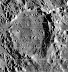
| Lunar Orbiter IV 97 h1 |
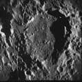
Apollo 10 AS10-32-4777 LPI scan |
Images
LPOD Photo Gallery Lunar Orbiter Images Apollo Images
- Rhaeticus was also captured in Apollo 10's oblique westward-looking Hasselblad frame AS10-32-4856. The northern half of it in AS10-33-4948. Rhaeticus at the local morning terminator (early in the mission of Apollo 10): AS10-31-4557.
- Although only the crews of Apollo 10 and Apollo 12 made orbital Hasselblad photographs of Rhaeticus, Apollo 16's Fairchild Metric/Mapping camera made a series of interesting oblique northward-looking photographs of Rhaeticus and surroundings. One of those photographs; AS16-M-0839, shows Rhaeticus below the central part of the curved horizon. The pronounced crater a bit further "up" toward the horizon is Triesnecker.
Research orbital Apollo 10 and Apollo 16 photography: Danny Caes
Maps
(LAC zone 59C4) LAC map Geologic map AIC map
Description
Description: Elger
(IAU Directions) RHAETICUS.--A very interesting formation, about 25 miles in diameter, situated near the lunar equator, with a border intersected by many passes. A deep rill-like valley winds round its western glacis, commencing on the S. at a small circular enclosure standing at the end of a spur from the wall; and, after crossing a ridge E. of a bright little crater on the N. of the formation, apparently joins the most westerly cleft of the Triesnecker system. A cleft traverses the N. side of the floor of Rhaeticus, and extends across the plain on the W. as far as the N. side of Reaumur.
Description: Wikipedia
Additional Information
Depth data from Kurt Fisher database
- Pike, 1976: 1.2 km
- Westfall, 2000: 1.2 km
- Cherrington, 1969: 1.58 km
Nomenclature
Georg Joachim von Lauchen, also known as Rheticus (February 16, 1514 – December 4, 1574), was a mathematician, cartographer, navigational and other instrument maker, medical practitioner, and teacher. He is perhaps best known for his trigonometric tables, and for facilitating the publication of Nicolaus Copernicus' De revolutionibus orbium coelestium (On the Revolutions of the Heavenly Spheres).
LPOD Articles
Bibliography
This page has been edited 1 times. The last modification was made by - tychocrater tychocrater on Jun 13, 2009 3:24 pm - afx3u2

