Difference between revisions of "Lyman"
(Created page with "<div id="content_view" class="wiki" style="display: block"> =Lyman= {| class="wiki_table" | Lat: 64.8°S, Long: 163.6°E, Diam: 84 km, Depth: km, Rükl: ''(farside)'', [ht...") |
|||
| Line 3: | Line 3: | ||
{| class="wiki_table" | {| class="wiki_table" | ||
| | | | ||
| − | Lat: 64.8°S, Long: 163.6°E, Diam: 84 km, Depth: km, Rükl: ''(farside)'', [http://the-moon. | + | Lat: 64.8°S, Long: 163.6°E, Diam: 84 km, Depth: km, Rükl: ''(farside)'', [http://the-moon.us/wiki/Stratigraphy Upper Imbrian]<br /> |
|} | |} | ||
<div id="toc"> | <div id="toc"> | ||
| Line 11: | Line 11: | ||
[http://www.lpod.org/coppermine/thumbnails.php?album=search&type=full&search=Lyman LPOD Photo Gallery] [http://www.lpi.usra.edu/resources/lunar_orbiter/bin/srch_nam.shtml?Lyman%7C0 Lunar Orbiter Images] [http://www.lpi.usra.edu/resources/apollo/search/feature/?feature=Lyman Apollo Images]<br /> <br /> | [http://www.lpod.org/coppermine/thumbnails.php?album=search&type=full&search=Lyman LPOD Photo Gallery] [http://www.lpi.usra.edu/resources/lunar_orbiter/bin/srch_nam.shtml?Lyman%7C0 Lunar Orbiter Images] [http://www.lpi.usra.edu/resources/apollo/search/feature/?feature=Lyman Apollo Images]<br /> <br /> | ||
==Maps== | ==Maps== | ||
| − | ''([http://the-moon. | + | ''([http://the-moon.us/wiki/LAC%20zone LAC zone] 141A2)'' [http://planetarynames.wr.usgs.gov/images/Lunar/lac_141.pdf USGS Digital Atlas PDF]<br /> <br /> |
==Description== | ==Description== | ||
<br /> | <br /> | ||
| Line 17: | Line 17: | ||
[http://en.wikipedia.org/wiki/Lyman_(crater) Lyman]<br /> <br /> | [http://en.wikipedia.org/wiki/Lyman_(crater) Lyman]<br /> <br /> | ||
==Additional Information== | ==Additional Information== | ||
| − | * [http://the-moon. | + | * [http://the-moon.us/wiki/Central%20peak%20composition Central peak composition]: AN & N ([http://the-moon.us/wiki/Tompkins%20%26%20Pieters%2C%201999 Tompkins & Pieters, 1999]) |
<br /> | <br /> | ||
==Nomenclature== | ==Nomenclature== | ||
Revision as of 19:23, 11 April 2018
Contents
Lyman
|
Lat: 64.8°S, Long: 163.6°E, Diam: 84 km, Depth: km, Rükl: (farside), Upper Imbrian |
Table of Contents
[#Lyman Lyman]
[#Lyman-Images Images]
[#Lyman-Maps Maps]
[#Lyman-Description Description]
[#Lyman-Description: Wikipedia Description: Wikipedia]
[#Lyman-Additional Information Additional Information]
[#Lyman-Nomenclature Nomenclature]
[#Lyman-LPOD Articles LPOD Articles]
[#Lyman-Bibliography Bibliography]
[#Lyman-Chester Smith Lyman in the Sourcebook Project (William R. Corliss) Chester Smith Lyman in the Sourcebook Project (William R. Corliss)]


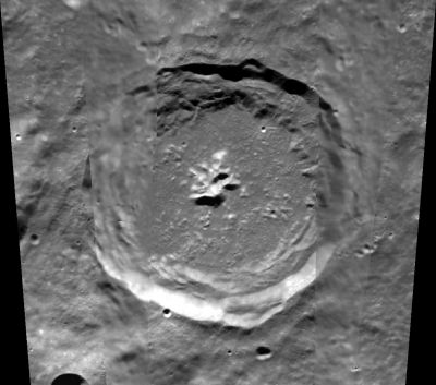
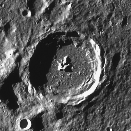
left: Clementine . right: LROC
Images
LPOD Photo Gallery Lunar Orbiter Images Apollo Images
Maps
(LAC zone 141A2) USGS Digital Atlas PDF
Description
Description: Wikipedia
Additional Information
Nomenclature
Theodore; American physicist (1874-1954).
  Perhaps interesting to know that there was also Chester Smith Lyman (1814-1890); American teacher, clergyman, astronomer.- DannyCaes DannyCaes Mar 29, 2015
LPOD Articles
Bibliography
Chester Smith Lyman in the Sourcebook Project (William R. Corliss)
- In Mysterious Universe, a handbook of astronomical anomalies (1979) :
- Page 94: Annular Phase of Venus (Lewis R. Gibbs, Science, 1890).
- Page 97: On the Visibility of the Dark Side of Venus (A. Schafarik, Report of the British Association, 1873).
This page has been edited 1 times. The last modification was made by - tychocrater tychocrater on Jun 13, 2009 3:24 pm - afx3u2