Difference between revisions of "Rimae Petavius"
| (3 intermediate revisions by the same user not shown) | |||
| Line 3: | Line 3: | ||
{| class="wiki_table" | {| class="wiki_table" | ||
| | | | ||
| − | Lat: 25.9°S, Long: 58.9°E, Length: 80 km, Depth: km, [ | + | Lat: 25.9°S, Long: 58.9°E, Length: 80 km, Depth: km, [[R%C3%BCkl%2059|Rükl 59]]<br /> |
|} | |} | ||
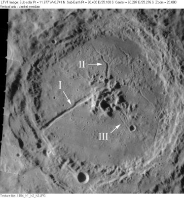
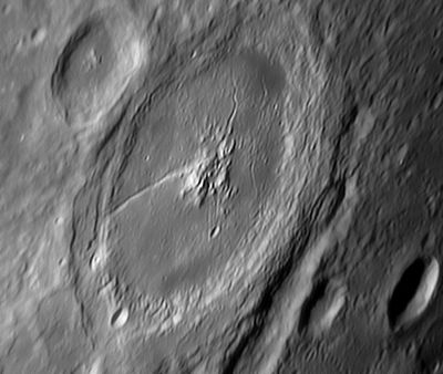
| − | [http://www.lpod.org/coppermine/displayimage.php?pid=3052&fullsize=1 [[Image: | + | [http://www.lpod.org/coppermine/displayimage.php?pid=3052&fullsize=1 [[Image:Normal_Rimae_Petavius_LO-IV-184H_LTVT.JPG|external image normal_Rimae_Petavius_LO-IV-184H_LTVT.JPG]]][http://www.lpod.org/coppermine/displayimage.php?pid=1020&fullsize=1 [[Image:Normal_Petavius.jpg|external image normal_Petavius.jpg]]]<br /> '''Left''': ''[http://lpod.org/coppermine/displayimage.php?pos=-3052 LO-IV-184H]'' Aerial view indicating the Roman-numeraled rilles of the ''[[System%20of%20Lunar%20Craters|System of Lunar Craters]]''. '''Right''': ''[http://lpod.org/coppermine/displayimage.php?pos=-1020 Colin Evans]'' Earth-based view.<br /> <br /> <div id="toc"> |
| − | + | ||
| − | |||
==Images== | ==Images== | ||
[http://www.lpod.org/coppermine/thumbnails.php?album=search&type=full&search=Rimae%20Petavius LPOD Photo Gallery] [http://www.lpi.usra.edu/resources/lunar_orbiter/bin/srch_nam.shtml?Rimae%20Petavius%7C0 Lunar Orbiter Images] [http://www.lpi.usra.edu/resources/apollo/search/feature/?feature=Rimae%20Petavius Apollo Images]<br /> <br /> | [http://www.lpod.org/coppermine/thumbnails.php?album=search&type=full&search=Rimae%20Petavius LPOD Photo Gallery] [http://www.lpi.usra.edu/resources/lunar_orbiter/bin/srch_nam.shtml?Rimae%20Petavius%7C0 Lunar Orbiter Images] [http://www.lpi.usra.edu/resources/apollo/search/feature/?feature=Rimae%20Petavius Apollo Images]<br /> <br /> | ||
==Maps== | ==Maps== | ||
| − | ''([ | + | ''([[LAC%20zone|LAC zone]] 98D2)'' [http://www.lpi.usra.edu/resources/mapcatalog/LAC/lac98/ LAC map] [http://www.lpi.usra.edu/resources/mapcatalog/usgs/I794/ Geologic map]<br /> <br /> |
==Description== | ==Description== | ||
<br /> | <br /> | ||
==Description: Elger== | ==Description: Elger== | ||
| − | ''([ | + | ''([[IAU%20directions|IAU Directions]])'' PETAVIUS.--The third member of the great meridional chain: a noble walled-plain, with a complex rampart, extending nearly 100 miles from N. to S., which encloses a very rugged convex floor, traversed by many shallow valleys, and includes a massive central mountain and one of the most remarkable clefts on the visible surface. ... There is a remarkable bifurcation of the border S. of [[Wrottesley|Wrottesley]]. A lower section separates from the main rampart and, extending to a considerable distance S.W. of it, encloses a wide and comparatively level area which is crossed by two short clefts. ... The great cleft, extending from the central mountains to the S.W. wall, and perhaps beyond, was discovered by Schroter on September 16, 1788, and can be seen in a 2 inch achromatic. In larger instruments it is found to be in places bordered by raised banks.<br /> <br /> |
==Description: Wikipedia== | ==Description: Wikipedia== | ||
[http://en.wikipedia.org/wiki/Rimae_Petavius Rimae Petavius]<br /> <br /> | [http://en.wikipedia.org/wiki/Rimae_Petavius Rimae Petavius]<br /> <br /> | ||
| Line 21: | Line 20: | ||
<br /> | <br /> | ||
==The ''railroad'' at the southwestern part of the rim of Petavius== | ==The ''railroad'' at the southwestern part of the rim of Petavius== | ||
| − | * I can't imagine it's a totally new discovery, this ''railroad''-like feature on the southwestern part of the rim of '''Petavius'''. What is it? It seems to ''start'' just east of '''Wrottesley''' (the crater which is touching the west-northwestern part of the rim of '''Petavius''') and it runs all the way to the southeast through the bowl-shaped crater '''Petavius C''', and... much further across the unimpressive craters '''Hase''' and '''Hase D''', until it meets '''Rimae Hase''' (or... are the ''railroad'' and '''Rimae Hase''' perhaps one and the same feature?). <span class="membersnap">- | + | * I can't imagine it's a totally new discovery, this ''railroad''-like feature on the southwestern part of the rim of '''Petavius'''. What is it? It seems to ''start'' just east of '''Wrottesley''' (the crater which is touching the west-northwestern part of the rim of '''Petavius''') and it runs all the way to the southeast through the bowl-shaped crater '''Petavius C''', and... much further across the unimpressive craters '''Hase''' and '''Hase D''', until it meets '''Rimae Hase''' (or... are the ''railroad'' and '''Rimae Hase''' perhaps one and the same feature?). <span class="membersnap">- DannyCaes <small>Jan 7, 2016</small></span> |
<br /> | <br /> | ||
==Nomenclature== | ==Nomenclature== | ||
| − | * Named for the crater ([ | + | * Named for the crater ([[Petavius|Petavius]]) within which the rilles are found. |
| − | * The current status of lunar rille names in the [ | + | * The current status of lunar rille names in the [[IAU%20nomenclature|IAU nomenclature]] is very unclear since the IAU never followed through on its [[IAU%20Transactions%20XVB|1973 promise]] to give rille systems "new and more appropriate designations." Instead, the [[IAU%20Planetary%20Gazetteer|IAU Planetary Gazetteer]] has so-far only lumped the old Roman-numeraled rilles together as "Rimae". In the present case, the original IAU nomenclature of [[Blagg%20and%20M%C3%BCller|Blagg and Müller]] (1935), had only a single rille: Elger's "great cleft", labeled "I" in the illustration above. The ''[[System%20of%20Lunar%20Craters|System of Lunar Craters]]'' added "II" and "III"; although the preparers of [http://www.lpi.usra.edu/resources/mapcatalog/LAC/lac98/ LAC 98] (also approved by the IAU), labeled "III", but combined "I" and "II" into a single '''Rima Petavius'''. The ''[[System%20of%20Lunar%20Craters|System of Lunar Craters]]'' also draws the rille paralleling the west rim of [[Petavius|Petavius]] as a sort of huge T-shaped extension of "I", but it is not clear from the drawing if it was meant to be included in the name. <span class="membersnap">- JimMosher</span> |
<br /> | <br /> | ||
==LPOD Articles== | ==LPOD Articles== | ||
| Line 32: | Line 31: | ||
==Bibliography== | ==Bibliography== | ||
| − | * [ | + | * [[A%20Portfolio%20of%20Lunar%20Drawings|A Portfolio of Lunar Drawings]] (Harold Hill), see: the first drawing in that book, on a number-less page. |
<br /> | <br /> | ||
---- | ---- | ||
| − | + | </div> | |
Latest revision as of 20:29, 16 April 2018
Contents
Rimae Petavius
|
Lat: 25.9°S, Long: 58.9°E, Length: 80 km, Depth: km, Rükl 59 |


Left: LO-IV-184H Aerial view indicating the Roman-numeraled rilles of the System of Lunar Craters. Right: Colin Evans Earth-based view.
Images
LPOD Photo Gallery Lunar Orbiter Images Apollo Images
Maps
(LAC zone 98D2) LAC map Geologic map
Description
Description: Elger
(IAU Directions) PETAVIUS.--The third member of the great meridional chain: a noble walled-plain, with a complex rampart, extending nearly 100 miles from N. to S., which encloses a very rugged convex floor, traversed by many shallow valleys, and includes a massive central mountain and one of the most remarkable clefts on the visible surface. ... There is a remarkable bifurcation of the border S. of Wrottesley. A lower section separates from the main rampart and, extending to a considerable distance S.W. of it, encloses a wide and comparatively level area which is crossed by two short clefts. ... The great cleft, extending from the central mountains to the S.W. wall, and perhaps beyond, was discovered by Schroter on September 16, 1788, and can be seen in a 2 inch achromatic. In larger instruments it is found to be in places bordered by raised banks.
Description: Wikipedia
Additional Information
The railroad at the southwestern part of the rim of Petavius
- I can't imagine it's a totally new discovery, this railroad-like feature on the southwestern part of the rim of Petavius. What is it? It seems to start just east of Wrottesley (the crater which is touching the west-northwestern part of the rim of Petavius) and it runs all the way to the southeast through the bowl-shaped crater Petavius C, and... much further across the unimpressive craters Hase and Hase D, until it meets Rimae Hase (or... are the railroad and Rimae Hase perhaps one and the same feature?). - DannyCaes Jan 7, 2016
Nomenclature
- Named for the crater (Petavius) within which the rilles are found.
- The current status of lunar rille names in the IAU nomenclature is very unclear since the IAU never followed through on its 1973 promise to give rille systems "new and more appropriate designations." Instead, the IAU Planetary Gazetteer has so-far only lumped the old Roman-numeraled rilles together as "Rimae". In the present case, the original IAU nomenclature of Blagg and Müller (1935), had only a single rille: Elger's "great cleft", labeled "I" in the illustration above. The System of Lunar Craters added "II" and "III"; although the preparers of LAC 98 (also approved by the IAU), labeled "III", but combined "I" and "II" into a single Rima Petavius. The System of Lunar Craters also draws the rille paralleling the west rim of Petavius as a sort of huge T-shaped extension of "I", but it is not clear from the drawing if it was meant to be included in the name. - JimMosher
LPOD Articles
Trenchant Observations on a Trench. On the Limb Again. LPOD (Repeat of 3/7/2006 A Bend in the Middle Moderate Sun over a Magnificent Crater On the Limb Again A New Kind of DHC Petavius Naked Petavius: Rilles & Volcanic Spots Four in a Row Limb Gift
Bibliography
- A Portfolio of Lunar Drawings (Harold Hill), see: the first drawing in that book, on a number-less page.