Difference between revisions of "Mare Nubium"
(Created page with "<div id="content_view" class="wiki" style="display: block"> =Nubium Basin= ''(unofficial name; IAU feature name for central 715 km of mare: '''Mare Nubium''')''<br /> {| c...") |
|||
| (2 intermediate revisions by the same user not shown) | |||
| Line 4: | Line 4: | ||
{| class="wiki_table" | {| class="wiki_table" | ||
| | | | ||
| − | Lat: 21.3°S, Long: 16.6°W, Main ring diam: 690 km, Basin depth: 1.63 km, [ | + | Lat: 21.3°S, Long: 16.6°W, Main ring diam: 690 km, Basin depth: 1.63 km, [[R%C3%BCkl%2054|Rükl: 54]]<br /> |
|} | |} | ||
| − | [http://www.lpod.org/coppermine/displayimage.php?pid=1357&fullsize=1 [[Image: | + | [http://www.lpod.org/coppermine/displayimage.php?pid=1357&fullsize=1 [[Image:Normal_Mare%20Nubium%20%2020070329%200016em.jpg|external image normal_Mare%20Nubium%20%2020070329%200016em.jpg]]][http://www.lpod.org/coppermine/displayimage.php?pid=2343&fullsize=1 [[Image:Normal_Nubium_Basin_LIDAR_LTVT.JPG|external image normal_Nubium_Basin_LIDAR_LTVT.JPG]]]<br /> Left: ''[http://lpod.org/coppermine/displayimage.php?pos=-1357 Howard Eskildsen]'', Right: ''[http://lpod.org/coppermine/displayimage.php?pos=-2343 Clementine]'', Clementine LIDAR Altimeter texture from [http://pdsmaps.wr.usgs.gov/PDS/public/explorer/html/lidrlvls.htm PDS Map-a-Planet] remapped to north-up aerial view by [http://www.henriksucla.dk/ LTVT]. The dot is the center position and the white circle the main ring position from Chuck Wood's [http://www.lpod.org/cwm/DataStuff/Lunar%20Basins.htm Impact Basin Database]. Grid spacing = 10 degrees.<br /> <br /> <div id="toc"> |
| − | + | ||
| − | |||
==Images== | ==Images== | ||
| − | [http://www.lpod.org/coppermine/thumbnails.php?album=search&type=full&search=Mare%20Nubium LPOD Photo Gallery] [http://www.lpi.usra.edu/resources/lunar_orbiter/bin/srch_nam.shtml?Mare%20Nubium%7C0 Lunar Orbiter Images] [http://www.lpi.usra.edu/resources/apollo/search/feature/?feature=Mare%20Nubium Apollo Images]<br /> '''WARNING''': the LPI's list of orbital Apollo photographs of '''Mare Nubium''' shows a series of Apollo 17 photographs. Impossible because Apollo 17's belt of orbits was way too north to make detailed photographs of '''Mare Nubium'''! (which was behind or very near the curved southern horizon).<span class="membersnap">- | + | [http://www.lpod.org/coppermine/thumbnails.php?album=search&type=full&search=Mare%20Nubium LPOD Photo Gallery] [http://www.lpi.usra.edu/resources/lunar_orbiter/bin/srch_nam.shtml?Mare%20Nubium%7C0 Lunar Orbiter Images] [http://www.lpi.usra.edu/resources/apollo/search/feature/?feature=Mare%20Nubium Apollo Images]<br /> '''WARNING''': the LPI's list of orbital Apollo photographs of '''Mare Nubium''' shows a series of Apollo 17 photographs. Impossible because Apollo 17's belt of orbits was way too north to make detailed photographs of '''Mare Nubium'''! (which was behind or very near the curved southern horizon).<span class="membersnap">- DannyCaes <small>Jul 30, 2010</small></span><br /> <br /> |
==Maps== | ==Maps== | ||
| − | ''([ | + | ''([[LAC%20zone|LAC zone]] 94B4)'' [http://www.lpi.usra.edu/resources/mapcatalog/LAC/lac94/ LAC map] [http://www.lpi.usra.edu/resources/mapcatalog/usgs/I485/ Geologic map]<br /> <br /> |
| − | ==[ | + | ==[[Lunar%20Basins|Basin Classification]]== |
(description of terms and most numeric basin data from Wood, C.A. (2004) [http://www.lpod.org/cwm/DataStuff/Lunar%20Basins.htm Impact Basin Database])<br /> | (description of terms and most numeric basin data from Wood, C.A. (2004) [http://www.lpod.org/cwm/DataStuff/Lunar%20Basins.htm Impact Basin Database])<br /> | ||
{| class="wiki_table" | {| class="wiki_table" | ||
| Line 47: | Line 46: | ||
[http://adsabs.harvard.edu/abs/2006M&PS...41..285B Stratigraphy and composition of lava flows in Mare Nubium and Mare Cognitum]<br /> <br /> | [http://adsabs.harvard.edu/abs/2006M&PS...41..285B Stratigraphy and composition of lava flows in Mare Nubium and Mare Cognitum]<br /> <br /> | ||
---- | ---- | ||
| − | + | </div> | |
Latest revision as of 02:03, 16 April 2018
Contents
Nubium Basin
(unofficial name; IAU feature name for central 715 km of mare: Mare Nubium)
|
Lat: 21.3°S, Long: 16.6°W, Main ring diam: 690 km, Basin depth: 1.63 km, Rükl: 54 |


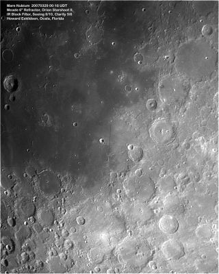
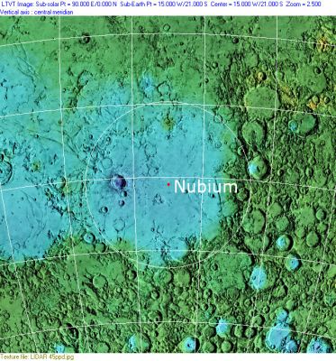
Left: Howard Eskildsen, Right: Clementine, Clementine LIDAR Altimeter texture from PDS Map-a-Planet remapped to north-up aerial view by LTVT. The dot is the center position and the white circle the main ring position from Chuck Wood's Impact Basin Database. Grid spacing = 10 degrees.
Images
LPOD Photo Gallery Lunar Orbiter Images Apollo Images
WARNING: the LPI's list of orbital Apollo photographs of Mare Nubium shows a series of Apollo 17 photographs. Impossible because Apollo 17's belt of orbits was way too north to make detailed photographs of Mare Nubium! (which was behind or very near the curved southern horizon).- DannyCaes Jul 30, 2010
Maps
(LAC zone 94B4) LAC map Geologic map
Basin Classification
(description of terms and most numeric basin data from Wood, C.A. (2004) Impact Basin Database)
| Certainty of Existence |
USGS Age |
Wilhelms Age Group |
Ring Diameters |
Mare Thickness |
Mascon |
| Uncertain |
Pre-Nectarian |
3 |
690 km |
Description
The pre-Nectarian Mare Nubium covers geographically nearly two-thirds of the area under study, centred at 21.3 S 16.6 W. Its official name since 1935, Mare Nubium, or “Sea of Clouds”, derives from early telescopic observations. The mare’s numerous ghost features, and various higher-albedo crater ejecta criss-crossing the basin, conjured up the idea of lunar clouds.

  Mare Nubium has a diameter of 750 km, and it is one of the most ancient circular basins on the Moon (Stuart-Alexander and Howard, 1970). Nevertheless, there is clear evidence that the basin did not form by a single large impact. Its present morphology appears to be a consequence of a number of major collisions. Morphological evidence of at least four major basin rings is still clearly identifiable (i.e. De Hon, 1977).
Description: Wikipedia
Additional Information
On September the 11th of 2013, a bright impact flash was observed at Mare Nubium. See LPOD Forming a New Crater.
Nomenclature
The IAU feature name means "Sea of Clouds".
- Named Continens Meridionalis (Southern Continent) in pre-telescopic sketch map by William Gilbert in ~1600. Name also included Cognitum, Insular and Humorum! [Whitaker: Mapping and Naming the Moon, p 15]
- The impact basin is named after the mare.
LPOD Articles
Forming a New Crater (the bright impact flash of September the 11th, 2013)
Bibliography
Stratigraphy and composition of lava flows in Mare Nubium and Mare Cognitum