Difference between revisions of "D. Brown"
| Line 5: | Line 5: | ||
|- | |- | ||
| | | | ||
| − | [http://lpod.org/coppermine/displayimage.php?pid=4321&fullsize=1 [[Image: | + | [http://lpod.org/coppermine/displayimage.php?pid=4321&fullsize=1 [[Image:Normal_dbrown-large.jpg|external image normal_dbrown-large.jpg]]]<br /> |
| | | | ||
| − | [[Image: | + | [[Image:Dbrown-large2.jpg|dbrown-large2.jpg]]<br /> |
|} | |} | ||
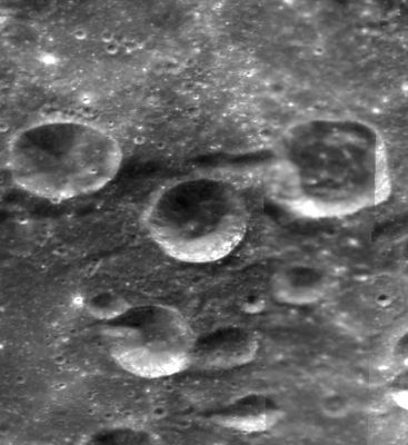
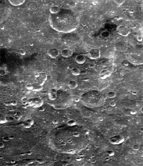
'''Left:''' [http://www.mapaplanet.org/explorer-bin/explorer.cgi?map=Moon&layers=moon_clementine_base_v2&info=NO&advoption=YES&sizeSelector=imageSize&lines=724&samples=1442&Resolution=32.2321428571428&r=1&g=1&b=1&projection=SIMP&grid=none&stretch=auto&north=-48.86&south=-37.66&west=202.45&east=224.79¢er_lat=0¢er=213.62&defaultcenter=on Close-up Clementine] image. '''Right:''' [http://www.mapaplanet.org/explorer-bin/explorer.cgi?map=Moon&layers=moon_clementine_base_v2&west=297&south=265&east=446&north=110¢er=212.75¢er_lat=0&defaultcenter=on&grid=none&stretch=auto&resamp_method=nearest_neighbor&projection=SIMP&r=1&g=1&b=1&advoption=YES&info=NO&resolution=13.8461538461538&lines=361&samples=720&scale=2.19001&imageTopX=-787312.1346235275&imageTopY=-901193.1666135788&box=yes&x=440&y=259 A broader Clementine view] -- both from [http://www.mapaplanet.org Map-A-Planet]. <div id="toc"> | '''Left:''' [http://www.mapaplanet.org/explorer-bin/explorer.cgi?map=Moon&layers=moon_clementine_base_v2&info=NO&advoption=YES&sizeSelector=imageSize&lines=724&samples=1442&Resolution=32.2321428571428&r=1&g=1&b=1&projection=SIMP&grid=none&stretch=auto&north=-48.86&south=-37.66&west=202.45&east=224.79¢er_lat=0¢er=213.62&defaultcenter=on Close-up Clementine] image. '''Right:''' [http://www.mapaplanet.org/explorer-bin/explorer.cgi?map=Moon&layers=moon_clementine_base_v2&west=297&south=265&east=446&north=110¢er=212.75¢er_lat=0&defaultcenter=on&grid=none&stretch=auto&resamp_method=nearest_neighbor&projection=SIMP&r=1&g=1&b=1&advoption=YES&info=NO&resolution=13.8461538461538&lines=361&samples=720&scale=2.19001&imageTopX=-787312.1346235275&imageTopY=-901193.1666135788&box=yes&x=440&y=259 A broader Clementine view] -- both from [http://www.mapaplanet.org Map-A-Planet]. <div id="toc"> | ||
Revision as of 01:45, 16 April 2018
Contents
[hide]D. Brown
| Lat: 42.0°S, Long: 147.2°W, Diam: 15 km, Depth: km, Rükl: (farside) | |
Images
LPOD Photo Gallery Lunar Orbiter Images Apollo Images
Maps
(LAC zone 121D2) USGS Digital Atlas PDF
Description
Named in honor of astronaut David McDowell Brown of the unfortunate Space Shuttle Columbia, the crater is one of several which lie in the Apollo Basin -- a 480 kilometre-wide basin of the pre-Nectarian period (~ 4.6 to 3.92 bn years). Probably classed as a bowl-like crater that was once cone-like, the rim is very sharp all around, while its floor show signs of infill material -- particularly in the north-eastern sector of the crater. This material has levelled the central regions somewhat, however, to the north-east some of this material has clumped into a jumbled set of hills -- possibly due to other impacts events in the region hereabouts. To the south-west of the crater's interior, a shield-like volcano feature is seen with a central pit shown, however, as to its certainty, this has yet to be clarified as we may be simply looking at a chance occurence of a small impact on just another ordinary-looking hill of material. - JohnMoore2 JohnMoore2
Description: Wikipedia
Additional Information
Nomenclature
David McDowell; American astronaut, Space Shuttle Columbia Mission Specialist (1956-2003).
LPOD Articles
Bibliography

