Difference between revisions of "Apollo"
| (One intermediate revision by the same user not shown) | |||
| Line 2: | Line 2: | ||
=Apollo Basin= | =Apollo Basin= | ||
''(unofficial name; IAU crater name: '''Apollo'''; 537 km diam)''<br /> <div id="toc"> | ''(unofficial name; IAU crater name: '''Apollo'''; 537 km diam)''<br /> <div id="toc"> | ||
| − | + | ||
| − | |||
{| class="wiki_table" | {| class="wiki_table" | ||
| Lat: 36.1°S, Long: 151.8°W, Main ring diam: 480 km, Depth: km, Rükl: ''(farside)''<br /> | | Lat: 36.1°S, Long: 151.8°W, Main ring diam: 480 km, Depth: km, Rükl: ''(farside)''<br /> | ||
|} | |} | ||
| − | [[Image:Apollo-MAP.jpg|Apollo-MAP.jpg]]<br /> Image mosaic from USGS Map-A-Planet<br /> [http://www.lpod.org/coppermine/displayimage.php?pid=2310&fullsize=1 [[Image: | + | [[Image:Apollo-MAP.jpg|Apollo-MAP.jpg]]<br /> Image mosaic from USGS Map-A-Planet<br /> [http://www.lpod.org/coppermine/displayimage.php?pid=2310&fullsize=1 [[Image:Normal_Apollo_Basin_LIDAR_LTVT.JPG|external image normal_Apollo_Basin_LIDAR_LTVT.JPG]]]<br /> ''[http://lpod.org/coppermine/displayimage.php?pos=-2310 LIDAR Altimeter]''<br /> Clementine LIDAR Altimeter texture from [http://pdsmaps.wr.usgs.gov/PDS/public/explorer/html/lidrlvls.htm PDS Map-a-Planet] remapped to north-up aerial view by [http://www.henriksucla.dk/ LTVT]. The dot is the center position and the white circle the main ring position from Chuck Wood's [http://www.lpod.org/cwm/DataStuff/Lunar%20Basins.htm Impact Basin Database].<br /> <br /> |
==Images== | ==Images== | ||
[http://www.lpod.org/coppermine/thumbnails.php?album=search&type=full&search=Apollo LPOD Photo Gallery] [http://www.lpi.usra.edu/resources/lunar_orbiter/bin/srch_nam.shtml?Apollo%7C0 Lunar Orbiter Images] [http://www.lpi.usra.edu/resources/apollo/search/feature/?feature=Apollo Apollo Images]<br /> <br /> '''Detection of a Concentric Crater at the northern part of Apollo'''<br /> Several photographs of the moon's far side, made by ZOND 8, show the northern part of the '''Apollo''' basin. For example: [http://www.mentallandscape.com/C_Zond08_41.jpg Frame 41], which shows '''Apollo''''s north-northwestern part near the frame's upper-right corner (above the black disc with white numbers in it). Also above this black disc (about "halfway" between the black disc and the frame's upper margin) is a [http://the-moon.us/wiki/Concentric%20Crater Concentric Crater] noticeable. The exact location of this concentric crater is 31° South/ 154° West (west of the pair of craters '''Scobee''' and '''Smith''').<br /> This concentric crater is also noticeable near the lower part of the left margin of [http://www.lpi.usra.edu/resources/lunarorbiter/images/preview/5030_h2.jpg Lunar Orbiter 5's frame 30-h2].<br /> Research ZOND 8 and Lunar Orbiter 5 photographs: Danny Caes<br /> This concentric crater is in the list published by Wood in [http://adsbit.harvard.edu/cgi-bin/nph-iarticle_query?1978LPI.....9.1264W 1978].<br /> <br /> | [http://www.lpod.org/coppermine/thumbnails.php?album=search&type=full&search=Apollo LPOD Photo Gallery] [http://www.lpi.usra.edu/resources/lunar_orbiter/bin/srch_nam.shtml?Apollo%7C0 Lunar Orbiter Images] [http://www.lpi.usra.edu/resources/apollo/search/feature/?feature=Apollo Apollo Images]<br /> <br /> '''Detection of a Concentric Crater at the northern part of Apollo'''<br /> Several photographs of the moon's far side, made by ZOND 8, show the northern part of the '''Apollo''' basin. For example: [http://www.mentallandscape.com/C_Zond08_41.jpg Frame 41], which shows '''Apollo''''s north-northwestern part near the frame's upper-right corner (above the black disc with white numbers in it). Also above this black disc (about "halfway" between the black disc and the frame's upper margin) is a [http://the-moon.us/wiki/Concentric%20Crater Concentric Crater] noticeable. The exact location of this concentric crater is 31° South/ 154° West (west of the pair of craters '''Scobee''' and '''Smith''').<br /> This concentric crater is also noticeable near the lower part of the left margin of [http://www.lpi.usra.edu/resources/lunarorbiter/images/preview/5030_h2.jpg Lunar Orbiter 5's frame 30-h2].<br /> Research ZOND 8 and Lunar Orbiter 5 photographs: Danny Caes<br /> This concentric crater is in the list published by Wood in [http://adsbit.harvard.edu/cgi-bin/nph-iarticle_query?1978LPI.....9.1264W 1978].<br /> <br /> | ||
| Line 55: | Line 54: | ||
<br /> <br /> | <br /> <br /> | ||
---- | ---- | ||
| − | + | </div> | |
Latest revision as of 18:43, 15 April 2018
Contents
Apollo Basin
(unofficial name; IAU crater name: Apollo; 537 km diam)| Lat: 36.1°S, Long: 151.8°W, Main ring diam: 480 km, Depth: km, Rükl: (farside) |

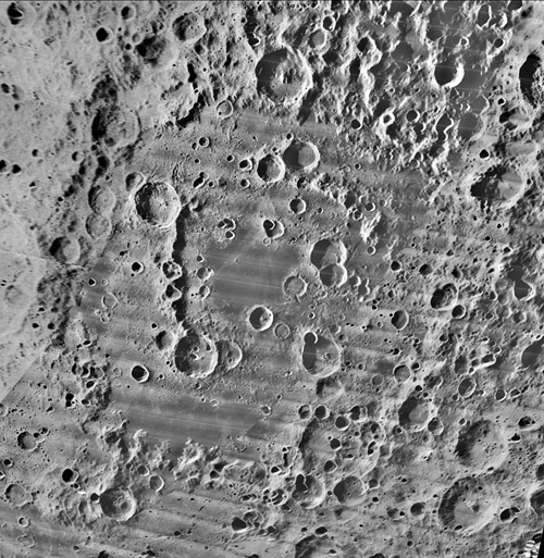
Image mosaic from USGS Map-A-Planet
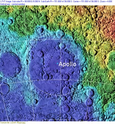
LIDAR Altimeter
Clementine LIDAR Altimeter texture from PDS Map-a-Planet remapped to north-up aerial view by LTVT. The dot is the center position and the white circle the main ring position from Chuck Wood's Impact Basin Database.
Images
LPOD Photo Gallery Lunar Orbiter Images Apollo Images
Detection of a Concentric Crater at the northern part of Apollo
Several photographs of the moon's far side, made by ZOND 8, show the northern part of the Apollo basin. For example: Frame 41, which shows Apollo's north-northwestern part near the frame's upper-right corner (above the black disc with white numbers in it). Also above this black disc (about "halfway" between the black disc and the frame's upper margin) is a Concentric Crater noticeable. The exact location of this concentric crater is 31° South/ 154° West (west of the pair of craters Scobee and Smith).
This concentric crater is also noticeable near the lower part of the left margin of Lunar Orbiter 5's frame 30-h2.
Research ZOND 8 and Lunar Orbiter 5 photographs: Danny Caes
This concentric crater is in the list published by Wood in 1978.
Maps
(LAC zone 121A3) USGS Digital Atlas PDF LRO LOLA Topo Map (See 4.23.2010)
Basin Classification
(description of terms and most numeric basin data from Wood, C.A. (2004) Impact Basin Database)
| Certainty of Existence |
USGS Age |
Wilhelms Age Group |
Ring Diameters |
Mare Thickness |
Mascon |
| Definite |
pre-Nectarian |
9 |
240, 480, 720 km |
1 km |
No, -39 mG gravity anomaly |
Description
Additional Information
- A small swirl of 275 km^2 is associated with Apollo (Hughes and others, 2006)
- Two small pyroclastic deposits (area = 69 and 2 km^2) in unnamed craters, NE Apollo. Gaddis, L. (1999) Lunar Pyroclastic Volcanism Project.
- Mare area of 18,300 km^2 according to measurements by Jim Whitford-Stark.
- Discovered by Stewart-Alexander & Howard (1970)
- Crater counts yield mare ages of 2.49 and 3.51 b.y. (N side), and 2.44 b.y. (S side), evidence of multiple periods of volcanism. Haruyama, J. and others, 2008.
- Concentric Crater (CC) at 31° South/ 154° West (at the north-northwestern part of Apollo)(west of craters Scobee and Smith).
- One of three basins with crustal thicknesses less than 5 km. The Crust of the Moon as Seen by Grail by Wieczorek et al (2013).
Nomenclature
- The IAU feature name honors the Apollo missions to the Moon. The name is a reference to the Greek God of light, Sun and other things.
- A small dark region at 145°20' West/ 40° South (at the southeastern part of the basin Apollo; in the triangle of craters Lovell, Borman, and Anders) is called Lacus Apollo 8 by Danny Caes.
- A rather large dark region at the southern part of the basin Apollo (in the triangle of craters Grissom, White, and Chaffee) is called Lacus Apollo 1 by Danny Caes.
LPOD Articles
Bibliography
- Morrison, DA & DBJ Bussey (1998). The Apollo and Korolev basins and the stratigraphy of the lunar crust. Lunar & Planet. Sci. 28, 1501.
- N. E. Petro; S. Tompkins; J. M. Sunshine; S. Besse; C. M. Pieters; J. W. Head; R. L. Klima; P. Isaacson; L. A. Taylor (2009). Distribution of Anorthositic and Noritic Material in the Apollo Basin AGU
