Difference between revisions of "Krasnov"
| Line 7: | Line 7: | ||
|} | |} | ||
<div id="toc"> | <div id="toc"> | ||
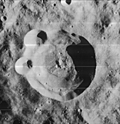
| − | + | [http://www.lpod.org/coppermine/displayimage.php?pid=1689&fullsize=1 [[Image:normal_Krasnov-LO-IV-4181-h1.jpg|external image normal_Krasnov-LO-IV-4181-h1.jpg]]]''[http://lpod.org/coppermine/displayimage.php?pos=-1689 LO-IV-4181-h1]''<br /> <br /> | |
| − | |||
==Images== | ==Images== | ||
[http://www.lpod.org/coppermine/thumbnails.php?album=search&type=full&search=Krasnov LPOD Photo Gallery] [http://www.lpi.usra.edu/resources/lunar_orbiter/bin/srch_nam.shtml?Krasnov%7C0 Lunar Orbiter Images]<br /> <br /> | [http://www.lpod.org/coppermine/thumbnails.php?album=search&type=full&search=Krasnov LPOD Photo Gallery] [http://www.lpi.usra.edu/resources/lunar_orbiter/bin/srch_nam.shtml?Krasnov%7C0 Lunar Orbiter Images]<br /> <br /> | ||
| Line 31: | Line 30: | ||
A Portfolio of Lunar Drawings (Harold Hill), page 150 (the Krasnov sector of the Mare Orientale region).<br /> <br /> | A Portfolio of Lunar Drawings (Harold Hill), page 150 (the Krasnov sector of the Mare Orientale region).<br /> <br /> | ||
---- | ---- | ||
| − | + | </div> | |
Revision as of 16:29, 15 April 2018
Contents
Krasnov
(formerly Lagrange F)
|
Lat: 29.9°S, Long: 79.6°W, Diam: 40 km, Depth: 4.56 km, Rükl: 50 |
Images
LPOD Photo Gallery Lunar Orbiter Images
Maps
(LAC zone 91C4) USGS Digital Atlas PDF
Description
Description: Wikipedia
Additional Information
Depth data from Kurt Fisher database
- Westfall, 2000: 4.56 km
Nomenclature
- Aleksander V. Krasnov (1866-1907), Russian astronomer.
- Name given by Arthur and Whitaker in Rectified Lunar Atlas (1963) and approved by IAU in 1964 (Whitaker, 1999, p234).
LPOD Articles
Bibliography
A Portfolio of Lunar Drawings (Harold Hill), page 150 (the Krasnov sector of the Mare Orientale region).
