Difference between revisions of "Van Vleck"
(Created page with "<div id="content_view" class="wiki" style="display: block"> =Van Vleck= ''(formerly '''[/Gilbert Gilbert] M''')''<br /> {| class="wiki_table" | Lat: 1.9°S, Long: 78.3°...") |
|||
| Line 1: | Line 1: | ||
<div id="content_view" class="wiki" style="display: block"> | <div id="content_view" class="wiki" style="display: block"> | ||
=Van Vleck= | =Van Vleck= | ||
| − | ''(formerly '''[ | + | ''(formerly '''[[Gilbert|Gilbert]] M''')''<br /> |
{| class="wiki_table" | {| class="wiki_table" | ||
| | | | ||
| − | Lat: 1.9°S, Long: 78.3°E, Diam: 34 km, Depth: 2.9 km, [ | + | Lat: 1.9°S, Long: 78.3°E, Diam: 34 km, Depth: 2.9 km, [[R%C3%BCkl%2049|Rükl: 49]]<br /> |
|} | |} | ||
<div id="toc"> | <div id="toc"> | ||
=Table of Contents= | =Table of Contents= | ||
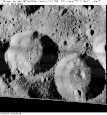
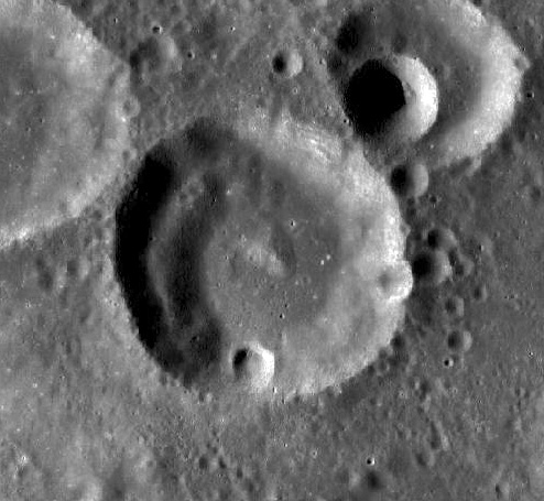
| − | <div style="margin-left: 1em">[#Van Vleck Van Vleck]</div><div style="margin-left: 2em">[#Van Vleck-Images Images]</div><div style="margin-left: 2em">[#Van Vleck-Maps Maps]</div><div style="margin-left: 2em">[#Van Vleck-Description Description]</div><div style="margin-left: 2em">[#Van Vleck-Description: Wikipedia Description: Wikipedia]</div><div style="margin-left: 2em">[#Van Vleck-Additional Information Additional Information]</div><div style="margin-left: 2em">[#Van Vleck-Nomenclature Nomenclature]</div><div style="margin-left: 2em">[#Van Vleck-LPOD Articles LPOD Articles]</div><div style="margin-left: 2em">[#Van Vleck-Bibliography Bibliography]</div></div>[http://www.lpod.org/coppermine/albums/userpics/Weierstrass_LO-I-025M_LTVT.JPG [[Image:normal_Weierstrass_LO-I-025M_LTVT.JPG|external image normal_Weierstrass_LO-I-025M_LTVT.JPG]]]<br /> ''[http://lpod.org/coppermine/displayimage.php?pos=-2961 LO-I-025M]'' '''Van Vleck''' is in the lower right. To its northwest is 33-km [ | + | <div style="margin-left: 1em">[#Van Vleck Van Vleck]</div><div style="margin-left: 2em">[#Van Vleck-Images Images]</div><div style="margin-left: 2em">[#Van Vleck-Maps Maps]</div><div style="margin-left: 2em">[#Van Vleck-Description Description]</div><div style="margin-left: 2em">[#Van Vleck-Description: Wikipedia Description: Wikipedia]</div><div style="margin-left: 2em">[#Van Vleck-Additional Information Additional Information]</div><div style="margin-left: 2em">[#Van Vleck-Nomenclature Nomenclature]</div><div style="margin-left: 2em">[#Van Vleck-LPOD Articles LPOD Articles]</div><div style="margin-left: 2em">[#Van Vleck-Bibliography Bibliography]</div></div>[http://www.lpod.org/coppermine/albums/userpics/Weierstrass_LO-I-025M_LTVT.JPG [[Image:normal_Weierstrass_LO-I-025M_LTVT.JPG|external image normal_Weierstrass_LO-I-025M_LTVT.JPG]]]<br /> ''[http://lpod.org/coppermine/displayimage.php?pos=-2961 LO-I-025M]'' '''Van Vleck''' is in the lower right. To its northwest is 33-km [[Weierstrass|Weierstrass]].<br /> [[Image:VanVleck-LRO.jpg|VanVleck-LRO.jpg]]<br /> LRO image.<br /> <br /> |
==Images== | ==Images== | ||
[http://www.lpod.org/coppermine/thumbnails.php?album=search&type=full&search=Van%20Vleck LPOD Photo Gallery] [http://www.lpi.usra.edu/resources/lunar_orbiter/bin/srch_nam.shtml?Van%20Vleck%7C0 Lunar Orbiter Images] [http://www.lpi.usra.edu/resources/apollo/search/feature/?feature=Gilbert%20M Apollo Images]<br /> <br /> | [http://www.lpod.org/coppermine/thumbnails.php?album=search&type=full&search=Van%20Vleck LPOD Photo Gallery] [http://www.lpi.usra.edu/resources/lunar_orbiter/bin/srch_nam.shtml?Van%20Vleck%7C0 Lunar Orbiter Images] [http://www.lpi.usra.edu/resources/apollo/search/feature/?feature=Gilbert%20M Apollo Images]<br /> <br /> | ||
==Maps== | ==Maps== | ||
| − | ''([ | + | ''([[LAC%20zone|LAC zone]] 81A2)'' [http://www.lpi.usra.edu/resources/mapcatalog/LTO/lto81a2_1/ LTO map]<br /> <br /> |
==Description== | ==Description== | ||
<br /> | <br /> | ||
| Line 18: | Line 18: | ||
[http://en.wikipedia.org/wiki/Van_Vleck_(crater) Van Vleck]<br /> <br /> | [http://en.wikipedia.org/wiki/Van_Vleck_(crater) Van Vleck]<br /> <br /> | ||
==Additional Information== | ==Additional Information== | ||
| − | Depth data from [ | + | Depth data from [[Kurt%20Fisher%20crater%20depths|Kurt Fisher database]]<br /> |
* Westfall, 2000: 3.03 km | * Westfall, 2000: 3.03 km | ||
LRO altimetry 2.6 km deep, 34 km in diameter, with 375 m high central peak. (CAW)<br /> <br /> | LRO altimetry 2.6 km deep, 34 km in diameter, with 375 m high central peak. (CAW)<br /> <br /> | ||
| Line 24: | Line 24: | ||
John Monroe; American astronomer, mathematician (1833-1912).<br /> | John Monroe; American astronomer, mathematician (1833-1912).<br /> | ||
| − | * This replacement name for a formerly [ | + | * This replacement name for a formerly [[lettered%20crater|lettered crater]] was provisionally introduced on [http://www.lpi.usra.edu/resources/mapcatalog/LTO/lto81a2_1/ LTO-81A2]. It was approved in 1976 ([[IAU%20Transactions%20XVIB|IAU Transactions XVIB]]). <span class="membersnap">- [http://www.wikispaces.com/user/view/JimMosher [[Image:JimMosher-lg.jpg|16px|JimMosher]]] [http://www.wikispaces.com/user/view/JimMosher JimMosher]</span> |
* Printed as '''Van Vle<u>k</u>''' on the revised and reprinted edition of the ''National Geographic Society'''s moonmap THE EARTH'S MOON (2014). | * Printed as '''Van Vle<u>k</u>''' on the revised and reprinted edition of the ''National Geographic Society'''s moonmap THE EARTH'S MOON (2014). | ||
<br /> | <br /> | ||
Revision as of 15:21, 15 April 2018
Contents
Van Vleck
(formerly Gilbert M)
|
Lat: 1.9°S, Long: 78.3°E, Diam: 34 km, Depth: 2.9 km, Rükl: 49 |
Table of Contents
[#Van Vleck Van Vleck]
[#Van Vleck-Images Images]
[#Van Vleck-Maps Maps]
[#Van Vleck-Description Description]
[#Van Vleck-Description: Wikipedia Description: Wikipedia]
[#Van Vleck-Additional Information Additional Information]
[#Van Vleck-Nomenclature Nomenclature]
[#Van Vleck-LPOD Articles LPOD Articles]
[#Van Vleck-Bibliography Bibliography]

LO-I-025M Van Vleck is in the lower right. To its northwest is 33-km Weierstrass.

LRO image.
Images
LPOD Photo Gallery Lunar Orbiter Images Apollo Images
Maps
Description
Description: Wikipedia
Additional Information
Depth data from Kurt Fisher database
- Westfall, 2000: 3.03 km
LRO altimetry 2.6 km deep, 34 km in diameter, with 375 m high central peak. (CAW)
Nomenclature
John Monroe; American astronomer, mathematician (1833-1912).
- This replacement name for a formerly lettered crater was provisionally introduced on LTO-81A2. It was approved in 1976 (IAU Transactions XVIB). - JimMosher JimMosher
- Printed as Van Vlek' on the revised and reprinted edition of the National Geographic Societys moonmap THE EARTH'S MOON (2014).
LPOD Articles
Bibliography
The Van Vleck Observatory (named after John M. Van Vleck) is mentioned on page 766 of Burnham's Celestial Handbook (Volume 2). See: Trigonometric Parallax for the star Chi Cygni. - DannyCaes DannyCaes May 4, 2015
This page has been edited 1 times. The last modification was made by - tychocrater tychocrater on Jun 13, 2009 3:24 pm - afx3u2