Lunar History - 1600s
Contents
[hide]- 1 Lunar Timeline: 1600's
- 1.1 1603: W Gilbert (1540-1603)
- 1.2 1609: T Harriot (1560-1621)
- 1.3 1610: Galileo Galilei (1564–1642)
- 1.4 1614: C Scheiner (1573-1650)
- 1.5 1636: C Mellan (1598-1688)
- 1.6 1645: MF Langrenus (1600–1675)
- 1.7 1645: AMS Rheita (1597-1660)
- 1.8 1646: F Fontana (1585-1646)
- 1.9 1647: J Hevelius (1611–1687)
- 1.10 1649: E Divini (1610-1685)
- 1.11 1651: GB Riccioli (1598-1671)
- 1.12 1662: G Montanari (1633-1687)
- 1.13 1665: Robert Hooke (1635-1703)
- 1.14 1680: GD Cassini (1625–1712)
Lunar Timeline: 1600's
1603: W Gilbert (1540-1603)
 Only known pre-telescopic drawing of the Moon which shows anything other than vague shadings. Gilbert's drawing is about the minimum a careful observer would notice! The locations and sizes of the maria are poor, and no craters - not even Tycho - are shown. Mare Crisium is named Brittannia. This drawing is famous for being the only pre-telescopic drawing, but it is not a careful redition of what is visible. Doubt me? If so go out and make your own naked eye sketch - it will be better.
1609: T Harriot (1560-1621)
First telescopic (6 power) map of the Moon.
1610: Galileo Galilei (1564–1642)
 Sidereus Nuncius (The Starry Messenger) - The first published drawings of the Moon as seen through a telescope. Galileo's drawings of first and last quarter. The main maria are easy to identify, but the large crater on the terminator of both drawings is larger than any in that area of the Moon and its identification is uncertain. The drawings are dramatic and relatively poor, but the description of mountains (and measures of their heights) and craters revealed that the Moon was not a perfect sphere as naively believed. Galileo initiated the scientific study of the Moon.
1614: C Scheiner (1573-1650)
Disquisitiones Mathematicae de controversiis et novitatibus astronomicis. Contains a drawing of first quarter Moon showing seas but virtually no craters.
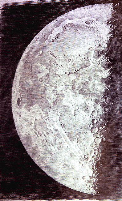
1636: C Mellan (1598-1688)
Very good engraving of second quarter Moon, with hundreds of identifiable features- the first good image of the Moon, drawn by an artist (one of a set of three engravings).
1645: MF Langrenus (1600–1675)
Selenographia, sive Lumina austriaca-philippica, Paris. - First nomenclature for craters and seas, but the only name that survives is his own for a crater near the Moon's eastern limb. Here is the map.
1645: AMS Rheita (1597-1660)
By misfortune his stylized and less informative map was published the same year as Langrenus's map. He emphasized mountains surrounding seas and Tycho's rays.
1646: F Fontana (1585-1646)
 A poor, measly-looking map with stylized representations of small equal sized craters.
1647: J Hevelius (1611–1687)
Selenographia, Gdansk - The first reasonably accurate chart and description of the Moon, but with a nomenclature scheme that has been forgotten. Wilkins and Moore (1955) report that the copperplate used to print his map was made into a teapot! How fleeting is fame.
1649: E Divini (1610-1685)
In many respects nothing more than a poor copy of the chart of Hevelius.
1651: GB Riccioli (1598-1671)
Almagestum Novum, Bologna - Based on his friend Grimaldi’s observations, Riccioli’s map established the present system of lunar names.
1662: G Montanari (1633-1687)
First map to pay attention to the many craters in the southern highlands.
1665: Robert Hooke (1635-1703)
Probably the earliest scientist to experimentally model the formation of lunar craters. In his 1665 book, Micrographia, the Englishman Hooke described experiments in which he dropped bullets into wet clay. He noted that the muddy splash crater so produced looked like features on the Moon, but he doubted that lunar craters formed in this manner because, “…it would be difficult to imagine whence those bodies [the projectiles] should come; and next, how the substance of the Moon should be so soft.” Hooke also made “volcanic” craters by cooling boiled plaster of paris which preserved the bubbles. Ref: Bevan M. French (1977) The Moon Book. Penguin, p 57.